
The allure of forgotten civilizations has long captivated the human imagination, acting as a persistent whisper at the edges of our collective memory. These are not merely stories of ancient peoples, but echoes of societies that once pulsed with life, innovation, and complexity, only to vanish, leaving behind tantalizing clues to their existence. Exploring these lost worlds is akin to piecing together a vast, fragmented mosaic, each shard offering a glimpse into a culture that shaped the landscape and influenced the course of human development, even in its absence. The discipline of archaeology, in its relentless pursuit of the past, acts as our guide, unearthing the silent sentinels that these civilizations left behind – cities swallowed by sand, underwater ruins, and subterranean complexes – challenging our understanding of history and our place within its grand tapestry.
The desert, often perceived as a barren expanse, can act as a powerful preserver, its sands a vast, silent tomb that has, in some instances, protected the remnants of once-thriving urban centers from the ravages of time and human intervention. These were not humble villages, but sophisticated metropolises, testaments to human ingenuity and adaptation in environments that would seem inhospitable to modern sensibilities. The discovery of these phantom cities is a triumph of persistent exploration and keen observation, revealing how ancient peoples carved out existence and built enduring legacies in the embrace of vast, unforgiving landscapes.
Ubar: The Atlantis of the Sands
The legend of Ubar, or Iram of the Pillars, has circulated for centuries, a mythical city described in ancient texts as a place of immense wealth and architectural splendor, ultimately punished for its hubris by divine wrath. For generations, it remained a tantalizing enigma, a ghost story whispered by Bedouin tribes and referenced in the Quran. Its existence was often dismissed as pure folklore, a poetic embellishment rather than historical reality.
The Search and the Discovery
The modern search for Ubar was fueled by a combination of folklore, historical texts, and advancements in satellite imagery. Explorers and archaeologists, guided by ancient maps and oral traditions, embarked on arduous expeditions into the Empty Quarter of Oman, one of the most inhospitable desert regions on Earth. The breakthrough came not through traditional digs, but through the application of orbital technology.
Satellite Archaeology: A New Lens
The use of Landsat satellite imagery proved instrumental. By analyzing the spectral signatures of the desert floor, researchers identified anomalies that suggested the presence of buried structures and ancient caravan routes. These faint suggestions in the vastness of the sand became breadcrumbs leading to the lost city.
The Identified Site
Subsequent ground surveys, guided by the satellite data, confirmed the presence of significant archaeological remains. The identified site aligned remarkably with the descriptions of Ubar found in ancient lore. Excavations uncovered evidence of a once-substantial city, complete with fortifications, towers, and evidence of a sophisticated water management system, crucial for survival in such an arid climate. The discovery suggested that Ubar was not a singular, monolithic city as some legends depicted, but rather a series of fortified settlements that controlled vital trade routes.
The Reality of Ubar: Trade Hub and Water Management
The archaeological evidence paints a picture of Ubar as a crucial lynchpin on ancient trade routes that spanned the Arabian Peninsula. It was a place where caravans laden with frankincense, spices, and other precious commodities converged, making it a hub of economic activity and cultural exchange. The wealth generated from this trade likely contributed to its legendary status.
Water: The Lifeblood of the Desert City
The most remarkable aspect of Ubar’s success was its ingenious water management system. In a region where water is scarce, the inhabitants developed sophisticated techniques to collect, store, and distribute this precious resource. This may have involved the construction of underground cisterns, channels, and possibly even wells that tapped into subterranean aquifers. The collapse or depletion of these water sources could have been a significant factor in the city’s abandonment, rather than a singular cataclysmic event.
The Decline and Abandonment
The decline of Ubar was likely a gradual process, influenced by shifting trade routes, environmental changes, and perhaps even localized seismic activity. The legend of its destruction might be a dramatized account of this slow fading from prominence. The sands eventually reclaimed what the desert offered, leaving an archaeological ghost for seekers to find.
The Navigators of the Atlantic: The Mystery of the Bimini Road
Beneath the azure waters of the Bahamas lies a structure that has sparked debate and ignited imaginations for decades: the Bimini Road. This submerged formation, a series of remarkably parallel and perpendicular limestone blocks, has been interpreted by some as evidence of an ancient, lost civilization that predates known human history in the region.
The Discovery and Initial Theories
The Bimini Road was first observed in the early 1960s by sightseers and divers. Its geometric regularity and unnatural appearance immediately set it apart from the surrounding seabed. Early theories, often sensationalized, proposed that the formation was the work of a highly advanced, unknown civilization, possibly Atlantis itself.
Geological vs. Archaeological Interpretations
The primary debate surrounding the Bimini Road centers on its origin: natural geological processes or deliberate construction by intelligent beings. Geologists often point to natural phenomena like wave erosion and the exfoliation of limestone as plausible explanations for the formation of such rectilinear patterns.
Wave Erosion and Limestone Exfoliation
The process of wave erosion in a carbonate-rich environment can, over long periods, break down rock formations into distinctly shaped blocks. Limestone, in particular, is susceptible to exfoliation, a process where layers of rock peel away, sometimes creating remarkably straight edges and right angles. Furthermore, the submerged nature of the site suggests it may have been above sea level in the distant past, a period when geological processes could have further shaped it.
Evidence for Artificial Construction
Despite geological explanations, some proponents of an artificial origin remain. They cite the precise alignment and interlocking nature of some of the blocks, suggesting a level of precision that might be difficult to achieve through purely natural means. The sheer scale of the purported construction also raises questions.
Geometric Precision and Arrangement
The remarkable parallelism and perpendicularity of the stones, forming what appears to be a paved roadway or wall, are central to the argument for artificial construction. Some researchers have measured angles and alignments that seem statistically unlikely to occur naturally. The sheer volume of material, if indeed quarried and positioned, would represent a significant undertaking.
The Argument from Intent
The core of the “artificial” argument lies in the perceived intent behind the formation. If it were natural, why would it exhibit such ordered, almost architectural characteristics? This leads to discussions about the capabilities of pre-historic peoples or even non-human intelligence.
The Scientific Consensus and Ongoing Debate
Currently, the scientific community leans heavily towards the geological explanation for the Bimini Road. The evidence for extensive underwater constructions by known ancient cultures in the Caribbean during the proposed timeframe is also sparse. However, the enduring mystery and the visually striking nature of the formation mean that the debate continues to capture the public imagination.
The Lack of Corroborating Evidence
A significant challenge for those who advocate for an artificial origin is the lack of corroborating evidence. No tools, artifacts, or any other signs of human habitation unequivocally linked to the Bimini Road have been discovered in the vicinity. This absence of material culture makes it difficult to definitively attribute the formation to a known or even an unknown human civilization.
The Future of Research
While the prevailing scientific view favors a natural explanation, further interdisciplinary research, potentially involving geologists, archaeologists, and oceanographers, could provide more conclusive answers. Techniques like underwater lidar mapping and more precise dating of the surrounding geological layers might help to resolve the lingering questions.
The exploration of forbidden history often leads to intriguing discussions about lost civilizations and their mysteries. A related article that delves into this captivating subject can be found at this link. It examines the evidence and theories surrounding ancient societies that have vanished from the historical record, inviting readers to ponder the implications of their existence and the secrets they may still hold.
The Sunken Cities of the Mediterranean
The Mediterranean Sea, a cradle of ancient civilizations, holds within its depths not only wrecks of merchant and naval vessels but also the submerged remnants of once-proud cities. These underwater metropolises offer a unique window into the past, providing insights into urban planning, architecture, and the dramatic environmental shifts that have reshaped coastlines over millennia.
Pavlopetri: A City Frozen in Time
Off the coast of southern Laconia in Greece lies Pavlopetri, an ancient city that was submerged by seismic activity approximately 3,000 years ago. Remarkably preserved beneath the waves, it provides an unparalleled glimpse into Bronze Age urban life.
The Discovery and Significance
Pavlopetri was discovered in 1967 by Dr. Robert L. Christiansen of the University of Pennsylvania. The city’s astonishing preservation, thanks to the low-oxygen, sediment-rich environment of its burial, sets it apart from most other submerged archaeological sites.
Bronze Age Urban Planning
The layout of Pavlopetri reveals a sophisticated understanding of urban planning. Streets, courtyards, and building foundations are clearly discernible, indicating a well-organized settlement with distinct residential, industrial, and potentially public areas. The scale of the city suggests a significant population.
Streets, Houses, and Public Spaces
Excavations have uncovered the remains of numerous buildings, many with intact floors and even walls. The distinct arrangement of these structures suggests a deliberate design, rather than haphazard growth. Evidence of workshops and pottery kilns also points to commercial and industrial activity within the city.
The Cataclysm and its Aftermath
The precise cause of Pavlopetri’s submersion is believed to be a combination of seismic activity and gradual sea-level rise. The tectonic setting of the region makes it prone to earthquakes, which could have caused significant land subsidence.
Seismic Activity and Land Subsidence
The Aegean region is characterized by complex tectonic plate interactions, leading to frequent seismic events. A significant earthquake could have caused the landmass upon which Pavlopetri stood to drop dramatically, plunging it beneath the sea.
Gradual Sea-Level Rise
Compounding the effect of seismic events, gradual sea-level rise, driven by climatic changes over millennia, would have further contributed to the submersion of coastal settlements. This gradual inundation would have ultimately rendered the city uninhabitable and led to its complete submergence.
Preservation and Future Research
The submerged environment of Pavlopetri has, paradoxically, acted as a powerful preservative. The lack of exposure to air and sunlight has limited the decay of organic materials and the erosion of structures.
The Advantages of an Underwater Environment
The consistent temperature and lack of oxygen in the seabed create conditions that significantly slow down the decomposition process. This allows for the preservation of details and materials that would likely have long since vanished on land.
Challenges of Underwater Excavation
Despite the preservation benefits, underwater archaeology presents its own unique challenges. The cost, logistical complexity, and the need for specialized equipment and trained personnel make extensive excavations difficult and expensive. However, advancements in underwater robotics and remote sensing technologies are beginning to mitigate some of these difficulties.
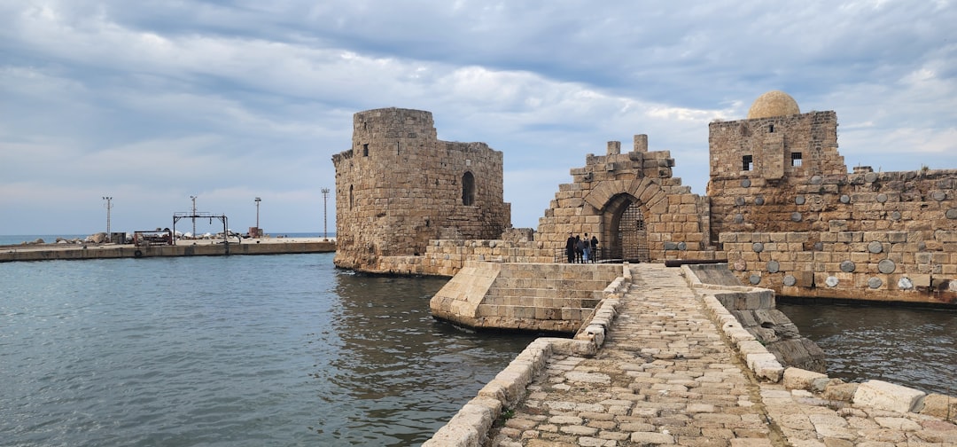
Thonis-Heracleion: The Gateway to Egypt
For centuries, the legendary city of Thonis-Heracleion was a mere footnote in ancient texts, a fabled port that served as the gateway to Egypt for merchants and travelers from the Greek world. Its existence was doubted by many, relegated to the realm of myth. However, the last two decades have witnessed the astonishing rediscovery of this lost metropolis, submerged in the waters of Aboukir Bay near Alexandria.
The Rediscovery and its Significance
The rediscovery of Thonis-Heracleion is one of the most significant archaeological finds of recent times. For over a thousand years, it lay hidden beneath the sea, a silent testament to a glorious past that had been largely forgotten.
Dr. Franck Goddio’s Explorations
The pivotal discoveries were made by the French underwater archaeologist Dr. Franck Goddio and his team, who, through meticulous sonar surveys and dives, began to unearth the sprawling remains of the city. Their work has painted a vivid picture of a once-thriving port.
Sonar Technology and Underwater Surveys
Advanced sonar technology played a crucial role, allowing researchers to map the seabed and identify anomalies that suggested submerged structures. These surveys guided the subsequent dives, pinpointing the most promising areas for excavation.
The City’s Role as a Major Port
Thonis-Heracleion was a cosmopolitan hub, a vital nexus for trade and cultural exchange between ancient Egypt and the wider Mediterranean world. Its strategic location at the mouth of the Nile River made it a crucial point of entry for goods and people.
The Trade Routes and Economic Power
The city controlled access to the fertile Nile delta, facilitating the export of Egyptian grain, papyrus, and luxury goods. In return, it received wine, silver, metals, and other commodities from Greece, Phoenicia, and beyond. This trade fueled its economic prosperity and cosmopolitan character.
The Bilingual Decrees and Greek Influence
Evidence of Thonis-Heracleion’s importance lies in the discovery of stelae inscribed with bilingual decrees, written in both Ancient Egyptian and Ancient Greek. These decrees highlight the city’s role as a place where Greek merchants and sailors were granted special privileges and religious protections, underscoring its dual Egyptian and Hellenistic identity.
Religious Importance and Temples
Beyond its commercial significance, Thonis-Heracleion was a major religious center, housing a magnificent temple dedicated to the god Amun. This temple was a destination for pilgrims and a site of important religious festivals.
The Temple of Amun-Gereb
The remains of a colossal temple complex, identified as the sanctuary of Amun-Gereb, have been uncovered. Statues of pharaohs and deities, along with colossal heads, speak to the grandeur of this sacred site, which likely played a significant role in Egyptian religious life.
The Great Stele and Deities
Among the most remarkable finds is a colossal stele that details the unification of Egypt under the pharaoh Ptolemy II. The temple area also yielded numerous statues of Egyptian deities, suggesting a vibrant religious life that blended Egyptian traditions with influences from the wider Mediterranean.
The Catastrophe and Submergence
Like Pavlopetri, Thonis-Heracleion succumbed to natural forces. A series of catastrophic events, likely a combination of earthquakes and subsequent tsunamis, led to its gradual inundation and eventual submersion.
Earthquakes and Tsunamis
Geological evidence suggests that the region experienced significant seismic activity, causing the land upon which the city stood to subside. This subsidence, coupled with powerful tsunamis, would have swept through the city, devastating its structures and eventually submerging it beneath the waves.
The Gradual Inundation
While catastrophic events likely accelerated the process, the gradual rise in sea levels over centuries would have also contributed to the city’s disappearance. The delta region, being low-lying, was particularly susceptible to these changes.
Lost Civilizations Beyond Human History
The concept of lost civilizations extends beyond those whose existence is evidenced by tangible archaeological remains. It also encompasses entities that challenge conventional timelines of human history or suggest intelligences that operated outside our current understanding. These are the whispers of the truly ancient, the enigmatic sites and artifacts that, if interpreted as artificial, hint at a past far deeper and more complex than we currently comprehend.
The Göbekli Tepe Enigma
Göbekli Tepe, located in southeastern Turkey, stands as a profound recalibration of our understanding of early human societal organization and intellectual capacity. This vast complex of megalithic structures, dating back to the Pre-Pottery Neolithic period (circa 9600-8200 BCE), predates the invention of pottery, agriculture, and even settled villages in many parts of the world.
The Discovery and its Implications
The discovery of Göbekli Tepe by Klaus Schmidt and his team has fundamentally altered our perception of the Neolithic Revolution. It suggests that complex ritualistic and social practices may have preceded the development of settled agriculture, a paradigm shift in historical studies.
The Age of the Structures
The sheer antiquity of Göbekli Tepe is its most striking feature. Radiocarbon dating has placed its earliest phases over 11,000 years ago, pushing back the timeline for monumental architecture and organized religious or social gathering sites by thousands of years.
Rethinking the Neolithic Revolution
Traditionally, it was believed that agriculture led to settled communities, which then allowed for the development of complex social structures and monumental architecture. Göbekli Tepe challenges this by suggesting that complex social organization and large-scale construction projects may have been a precursor to agriculture, driven by shared ritualistic or spiritual needs.
The Monumental Architecture and Symbolism
The site is characterized by its massive T-shaped limestone pillars, many adorned with intricate carvings of animals and abstract symbols. These pillars are arranged in circular enclosures, suggesting a communal purpose.
The T-Shaped Pillars and their Meaning
The T-shaped pillars, some weighing many tons, are believed to represent anthropomorphic beings or abstract symbols of cosmic importance. Their deliberate placement and colossal scale point to a highly organized society capable of significant labor mobilization.
Animal Carvings and Abstract Glyphs
The relief carvings on the pillars depict a diverse array of animals, including lions, boars, foxes, snakes, and birds. These are often rendered with striking realism. Alongside these animal motifs are abstract symbols whose meanings remain enigmatic, fueling speculation about an early form of symbolic language or mythology.
The Purpose of Göbekli Tepe
The exact purpose of Göbekli Tepe remains a subject of ongoing debate and research. However, prevailing theories suggest it was a ritualistic or ceremonial center, a place for communal gatherings, astronomical observation, or even a pilgrimage site.
Ritualistic and Ceremonial Site
The lack of evidence for domestic habitation within the immediate vicinity of the main structures points towards a non-residential function. The carvings and symbolic representations suggest a focus on spiritual or cosmological beliefs.
Astronomical Alignments and Calendrical Functions
Some researchers have proposed that the site incorporates astronomical alignments, potentially serving as an ancient observatory or a device for tracking celestial events and seasons. Such capabilities would have been vital for early hunter-gatherer societies.
The Abandonment and Burial
After centuries of use, Göbekli Tepe was deliberately backfilled and buried. The reasons for this are unknown, but it is speculated that it may have been a ritualistic act of decommissioning or a response to environmental changes that made the site unsafe or obsolete. This act of burial, however, played a crucial role in its remarkable preservation.
The Deliberate Backfilling
The act of burying the complex was not a result of natural decay or collapse. Layers of earth and debris were systematically piled onto the structures, effectively protecting them from erosion and deterioration for millennia.
The Mystery of its Decline
The reasons behind this deliberate act of burial remain one of Göbekli Tepe’s most significant mysteries. It hints at a conscious decision by its creators to “close” the site, a practice that has parallels in later ancient cultures.
The Enigmatic Structures of the Andes: Beyond Inca Lore
The Andes Mountains, a colossal spine of South America, are replete with archaeological wonders that extend far beyond the renowned empire of the Inca. Numerous ancient sites, characterized by their cyclopean stonework and sophisticated engineering, suggest the presence of pre-Inca civilizations with advanced knowledge and capabilities that continue to puzzle researchers.
Sacsayhuamán: The Fortress of Giants
Perched above Cusco, the former capital of the Inca Empire, the fortress of Sacsayhuamán is a marvel of ancient engineering. Its colossal stone walls, constructed from massive, precisely cut polygonal blocks, have led to persistent speculation about the methods used in their construction and the identity of their original builders.
The Scale and Precision of the Masonry
The most striking feature of Sacsayhuamán is the sheer size and weight of its stones. Some of these blocks weigh over 100 tons, and their fitting is so precise that a thin blade cannot be inserted between them.
Polygonal Masonry: A Sign of Advanced Skill
The characteristic polygonal masonry of Sacsayhuamán, where irregularly shaped stones are interlocked like a jigsaw puzzle, is a testament to the advanced masonry skills of its creators. This technique, without the use of mortar, creates incredibly stable and earthquake-resistant structures.
The “Impossible” Construction Debate
The debate surrounding Sacsayhuamán often centers on how such massive stones were quarried, transported, and fitted with such remarkable precision using the tools and technology believed to be available to the Inca.
Proposed Builders: Inca or Precursors?
While traditionally attributed to the Inca, the scale and sophistication of Sacsayhuamán have led some researchers to propose that it was built by an even earlier, more advanced civilization, with the Inca later repurposing and expanding upon existing structures.
The Inca’s Known Capabilities
The Inca were undoubtedly skilled engineers and builders, capable of impressive feats of construction. They developed sophisticated architectural techniques and organized vast labor forces.
Evidence of Earlier Construction
However, some archaeologists and independent researchers point to stylistic differences in certain sections of the walls, as well as the sheer impossibility of moving and shaping some of the largest blocks with known Inca technology, as evidence of a pre-Inca origin. The possibility exists that the Inca inherited and elaborated upon an even older, more monumental tradition.
Theories of Construction: The Conventional and the Controversial
Various theories have been put forth to explain the construction of Sacsayhuamán, ranging from conventional archaeological explanations to more speculative hypotheses.
Quarrying, Transportation, and Shaping Methods
Conventional theories involve the use of ramps, levers, rollers, and large labor forces to move and position the massive stones. The precise shaping is thought to have been achieved through abrasion with harder stones and sand.
Controversial Hypotheses: Sonic Technology and Alien Intervention
More controversial theories propose the use of sonic technology to vibrate and shape the stones, or even the intervention of extraterrestrial beings. These hypotheses often stem from the perceived technological gap between the construction and the presumed capabilities of the era.
The Purpose of the Fortress
The primary function of Sacsayhuamán is widely believed to have been defensive. Its strategic location and formidable walls would have provided a strong vantage point and a secure stronghold.
Defensive Capabilities and Strategic Importance
The towering walls and the zigzagging layout of the fortifications would have presented a formidable obstacle to attackers, offering both defensive advantage and clear lines of sight for defenders.
Ritualistic and Ceremonial Uses
Beyond its military purpose, it is also theorized that Sacsayhuamán may have served religious or ceremonial functions, with its vast plazas and open spaces potentially used for important gatherings or rituals.
Puma Punku: The Gateway of the Puma
Puma Punku, part of the Tiwanaku archaeological site in Bolivia, is renowned for its strangely precise, H-shaped stone blocks and its seemingly machined surfaces. This site has become a touchstone for theories about advanced lost civilizations due to the uncanny geometric perfection of its stonework.
The Unconventional Stonework of Puma Punku
The defining characteristic of Puma Punku is its stonework. The site features an abundance of precisely cut, rectangular blocks, some with intricate interlocking joints and smoothly polished surfaces, that appear almost as if they were cut with modern machinery.
The H-Blocks and Precision Cutting
The most famous elements are the “H-blocks,” large, symmetrical stones with precisely cut notches and perfectly parallel edges. The intricacy of these cuts and the flatness of some surfaces defy easy explanation using conventional ancient tools.
The Absence of Tool Marks and Seams
The remarkable absence of visible tool marks on many of the blocks, coupled with the near-perfect fit of interlocking sections, has fueled speculation that conventional methods of quarrying, shaping, and fitting stones were not the primary means of construction.
Theories of Construction: The Conventional and the Speculative
Similar to Sacsayhuamán, the construction of Puma Punku lies at the heart of an ongoing debate.
Traditional Archaeological Explanations
Traditional explanations suggest that the Tiwanaku people, known for their advanced engineering and agricultural techniques, employed a combination of abrasion, possibly using copper tools and abrasive sands, and immense human labor to achieve the results.
The Challenges of Conventional Theories
However, the sheer consistency and precision of the cuts, particularly on the H-blocks, present a significant challenge for conventional explanations. The time and effort required to achieve such results using only abrasion and primitive tools are difficult to quantify.
The Purpose of Puma Punku
The precise function of Puma Punku remains a mystery. It is believed to have been part of a larger ceremonial complex, possibly serving as a ceremonial gateway or a temple dedicated to the sun or other celestial bodies.
Ceremonial Gateway or Temple Function
The elevated platform and the arrangement of the blocks suggest a ritualistic or symbolic purpose, rather than a purely utilitarian one. Its placement within the larger Tiwanaku site points to its importance in the religious or political life of the civilization.
Possible Astronomical Significance
The alignment of certain features at Puma Punku with celestial events has led to suggestions of astronomical or calendrical significance, although definitive evidence is scarce.
The Tiwanaku Civilization: A Precursor to the Inca
Puma Punku is intrinsically linked to the Tiwanaku civilization, a powerful culture that flourished in the Andean highlands from around 100 to 1000 CE. The Tiwanaku people were known for their advanced agricultural systems, complex urban planning, and impressive stonework. The decline of the Tiwanaku civilization remains a subject of study, with theories pointing to environmental factors, internal conflict, or the rise of neighboring powers.
The Legacy of the Tiwanaku Culture
The influence of Tiwanaku extended far beyond its immediate geographical reach, impacting the development of subsequent Andean cultures, including the Inca. Their architectural innovations and agricultural techniques were foundational in the region.
The Collapse of Tiwanaku
The reasons for the decline and eventual collapse of the Tiwanaku civilization are complex and debated. Evidence suggests a combination of factors, including prolonged drought, ecological degradation, and internal social and political pressures, may have contributed to their downfall.
The study of lost civilizations is not simply an academic exercise; it is an ongoing human endeavor to understand our origins, our potential, and the vast, uncharted territories of our past. These forgotten metropolises and enigmatic structures serve as potent reminders that history is not a static monolith, but a dynamic, ever-unfolding narrative, rich with secrets waiting to be unearthed. Each discovery, each deciphered clue, adds another brushstroke to the grand, incomplete portrait of human civilization, reminding us of the boundless ingenuity and the deep mysteries that lie at the very foundations of our existence.
STOP: Why They Erased 50 Impossible Inventions From Your Textbooks
FAQs
What is meant by “forbidden history” in the context of lost civilizations?
“Forbidden history” refers to historical narratives or evidence about ancient civilizations that are often overlooked, suppressed, or disputed by mainstream academia. It involves exploring alternative theories and findings that challenge conventional historical timelines and interpretations.
Which civilizations are commonly discussed in the study of lost civilizations?
Commonly discussed lost civilizations include Atlantis, Lemuria, the Indus Valley Civilization, the Olmec civilization, and the Anasazi. These societies are studied for their advanced technologies, mysterious disappearances, or significant cultural contributions that have been lost or obscured over time.
What types of evidence are used to study lost civilizations?
Researchers use archaeological artifacts, ancient texts, architectural ruins, geological data, and sometimes oral traditions to study lost civilizations. Advances in technology, such as satellite imagery and carbon dating, also help uncover and analyze evidence related to these ancient societies.
Why are some aspects of lost civilizations considered “forbidden” or controversial?
Certain aspects are considered “forbidden” because they challenge established historical and scientific views, potentially contradicting accepted timelines or cultural narratives. This can lead to skepticism or rejection by mainstream scholars, making such topics controversial within academic and public discourse.
How do lost civilizations contribute to our understanding of human history?
Studying lost civilizations provides insights into early human innovation, cultural development, and societal organization. It helps historians and archaeologists understand migration patterns, technological advancements, and the rise and fall of complex societies, enriching our overall knowledge of human history.