
Exploring the subterranean architecture of our planet reveals a complex network of geological features, among which lineaments hold significant importance. These linear features, observable from various scales of geological mapping and remote sensing, are often indicative of underlying structural discontinuities within the Earth’s crust. Understanding the formation and behavior of these lineaments is crucial for a wide range of geological investigations, from resource exploration to seismic hazard assessment and, increasingly, for the study of geological hydrogen migration pathways.
This article delves into the intricate relationship between geological lineaments and the movement of geological hydrogen. It will explore how these linear features can act as conduits, barriers, or modifiers of hydrogen flow within the subsurface, influencing its distribution and accumulation.
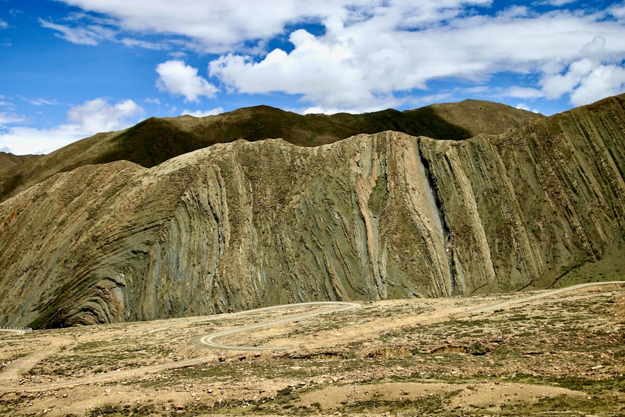
Geological lineaments are linear or curvilinear features that are interpreted to represent underlying geological structures. They are not necessarily surface topographic features but are often inferred from patterns observed in imagery such as aerial photographs, satellite imagery, or digital elevation models. Their identification relies on the visual interpretation of subtle changes in tone, texture, vegetation patterns, drainage networks, or geomorphic expression.
Types of Geological Lineaments
Lineaments can manifest in various forms, reflecting the diverse geological processes that create them.
Tectonic Lineaments
These are often associated with faults, fault zones, or major fracture systems. Their orientation and extent are typically controlled by regional stress fields and lithological variations. Tectonic lineaments can represent zones of weakness within the crust, where rocks have been deformed and fractured.
Lithological Contacts
Sharp transitions in rock types, particularly where there is a significant difference in resistance to erosion or in the spectral properties of the rocks, can create lineaments. These might represent stratigraphically controlled features or intrusive boundaries.
Geomorphic Lineaments
These are lineaments directly expressed in the landscape, such as straight river segments, aligned ridges, or scarps. While geomorphology is a surface phenomenon, it often reflects underlying geological structures that have influenced erosion and depositional processes over time.
Drainage Lineaments
The alignment of stream segments or the deflection of drainage networks can indicate the presence of underlying linear structures that influence groundwater flow and erosional patterns.
Methods for Lineament Identification
The identification and mapping of geological lineaments have evolved significantly with advancements in technology.
Traditional Photogeology
Early methods relied on stereoscopic interpretation of aerial photographs. Geologists would meticulously examine pairs of overlapping photographs to identify linear features that stood out from the surrounding terrain.
Remote Sensing and GIS
Modern approaches leverage satellite imagery from various sensors (e.g., optical, radar) and Geographic Information Systems (GIS). Advanced image processing techniques, such as edge enhancement, directional filtering, and principal component analysis, are employed to accentuate subtle linear features. GIS platforms then allow for the integration of different datasets, the precise delineation of lineaments, and their spatial analysis.
Geophysical Data Integration
While lineaments are often identified from imagery, their subsurface expression can be confirmed and characterized using geophysical methods. Gravity, magnetic, and seismic surveys can reveal anomalies and structures that correlate with interpreted lineaments, providing insights into their depth and nature.
Geological lineaments play a crucial role in understanding hydrogen migration pathways, as they often dictate the movement of fluids within the Earth’s crust. A related article that explores the implications of geological features on resource distribution and environmental impact can be found at this link. By examining the relationship between geological structures and hydrogen migration, researchers can better assess potential energy resources and their sustainable management.
Lineaments as Potential Hydrogen Migration Pathways
The Earth’s crust is not a uniform, impermeable barrier. It is a complex, fractured medium where fluids, including gases like hydrogen, can migrate through interconnected pore spaces and fracture networks. Geological lineaments, by their very nature as zones of structural weakness or heterogeneity, are prime candidates for facilitating this migration.
Fractures and Faults as Conduits
The most common interpretation of tectonic lineaments is their association with faults and fracture systems. These features create zones of enhanced permeability, allowing fluids to move more freely than through the intact rock matrix.
Fault Zones and Hydrogen Flow
Fault zones are typically characterized by brecciation, gouge formation, and the development of secondary fractures. These processes can significantly increase the permeability and porosity of the fault core and the surrounding fractured rock mass. If hydrogen is present at depth, these fault zones can act as preferential pathways for its upward or lateral migration. The extent and connectivity of these fractured zones within a fault system will dictate the efficiency of hydrogen transport.
Joint Networks and Microfractures
Even in the absence of major faulting, regional stress can induce extensive joint networks and microfractures within rock masses. Where these joints are favorably oriented and interconnected, they can also contribute to subsurface fluid flow. Lineaments that reflect regional joint sets or significant tensile stress regimes could therefore represent important hydrogen migration pathways.
Permeability Heterogeneities Associated with Lineaments
Beyond direct fracturing, lineaments can also indicate zones where there are changes in rock properties that affect permeability.
Lithological Boundaries and Permeability Contrast
As mentioned, some lineaments may simply represent the boundary between distinct rock units. If these units have different intrinsic permeabilities, the boundary itself can become a zone of preferential flow. For example, a permeable sandstone adjacent to an impermeable shale formation, delineated by a lineament, could guide fluid movement along the contact.
Alteration Zones
Geological processes associated with lineaments, such as hydrothermal activity or fluid circulation along faults, can lead to alteration of the host rocks. These alteration zones might exhibit different porosity and permeability characteristics compared to the un-altered country rock. They can thus influence the direction and rate of hydrogen migration.
The Role of Lineaments in Hydrogen Trapping and Accumulation
While lineaments can facilitate hydrogen migration, they can also play a role in its trapping and accumulation, forming potential geological hydrogen reservoirs.
Barriers to Hydrogen Migration
Conversely to acting as conduits, lineaments can also act as barriers to hydrogen migration. This occurs when the geological features associated with the lineament represent zones of significantly reduced permeability.
Impermeable Lithologies Along Lineaments
A lineament might mark the boundary with an impermeable lithological unit, such as a thick claystone or evaporite formation. If hydrogen migrating upwards encounters such a barrier, its movement could be impeded, leading to accumulation beneath the impermeable layer.
Mineral Precipitation and Sealing
Hydrothermal fluids circulating along fault zones can precipitate minerals that effectively seal fractures and reduce permeability. If such sealing has occurred along a lineament, it can create a structural trap for migrating hydrogen.
Structural Traps Formed by Lineaments
The geometry of lineaments and their associated geological structures can create favorable conditions for the formation of structural traps.
Anticlinal Structures and Fault Traps
Where lineaments are associated with folded structures or complex fault geometries, they can create traps. For instance, if a fault juxtaposes a permeable reservoir rock against an impermeable caprock, and this fault is oriented along a lineament, it can form a trap. Similarly, anticlinal folds, which can be influenced by underlying basement structures often expressed as lineaments, are classic traps for hydrocarbons and potentially for geological hydrogen.
Stratigraphic Traps Modified by Lineaments
Lineaments can also influence stratigraphic traps. For example, a pinch-out of a permeable formation within an impermeable sequence, where this pinch-out is guided or truncated by a lineament, could create a localized trapping scenario.
Case Studies and Observational Evidence

While research into geological hydrogen is a relatively nascent field, initial observations and studies are beginning to link lineaments to hydrogen occurrences.
Correlation with Well Data
In areas where geological hydrogen has been detected in wells, geologists often observe correlations between hydrogen occurrences and known lineaments or inferred subsurface fracture zones derived from seismic data.
Natural Hydrogen Discoveries and Structural Control
Several natural hydrogen discoveries, particularly those in ancient shield terrains, are being investigated for their structural controls. Many of these occurrences are located in proximity to major fault systems or zones of intense fracturing, which are often expressed as prominent lineaments in remote sensing data.
Isotopic Signatures and Migration Pathways
The isotopic composition of detected geological hydrogen can provide clues about its origin and migration pathways. If this migration is controlled by fracture networks, then lineaments associated with these fractures would be expected to show higher concentrations or distinct isotopic signatures.
Geophysical Anomalies Associated with Lineaments
Geophysical investigations in areas with potential geological hydrogen systems are revealing further connections with lineaments.
Magnetic and Gravity Anomalies
Lineaments often correspond to linear geophysical anomalies, such as magnetic or gravity lineaments. These anomalies can indicate variations in lithology or structural discontinuities at depth. If these discontinuities are associated with hydrogen generation or migration, these geophysical signatures become important exploration indicators.
Seismic Interpretation of Fractured Zones
Advanced seismic imaging techniques can reveal the presence of fractured zones and fault lines within the subsurface. When these seismic interpretations align with identified lineaments, it strengthens the hypothesis that these lineaments represent active migration pathways for geological fluids, including hydrogen.
Geological lineaments play a crucial role in understanding hydrogen migration pathways, as they often indicate the presence of subsurface fractures and faults that can facilitate the movement of gases. A fascinating exploration of how geological features can reveal hidden resources can be found in a related article that discusses various shocking discoveries made through mapping techniques. You can read more about these incredible findings and their implications for resource management by visiting this link: shocking discoveries. Understanding these connections is essential for both geologists and environmental scientists as they seek to harness hydrogen as a clean energy source.
Future Directions in Lineament Analysis for Hydrogen Exploration
| Geological Lineaments and Hydrogen Migration Pathways | Metrics |
|---|---|
| Length of Lineaments | Measured in kilometers |
| Orientation of Lineaments | Measured in degrees |
| Hydrogen Migration Rate | Measured in cubic meters per second |
| Depth of Hydrogen Migration Pathways | Measured in meters |
The growing interest in geological hydrogen necessitates a more focused and integrated approach to lineament analysis.
High-Resolution Remote Sensing and Advanced Image Processing
The utilization of higher-resolution satellite imagery and the application of more sophisticated image processing algorithms will be crucial for identifying subtle lineaments that might otherwise be overlooked. This includes techniques that can delineate microfracture networks and subtle geomorphic expressions of subsurface structures.
Integration of Multidisciplinary Datasets
The most effective approach will involve the comprehensive integration of various datasets. This includes not only remote sensing data but also a wide range of geophysical data (seismic, gravity, magnetic), borehole data (including geochemical analyses), and structural geological mapping. GIS platforms will be essential for managing and analyzing this complex data landscape.
Advanced Geomechanical Modeling
Developing geomechanical models that incorporate the influence of lineaments on regional stress fields and fluid flow will be critical. These models can simulate hydrogen generation, migration, and accumulation under various geological scenarios, helping to predict areas with higher potential. Understanding how stress affects fracture aperture and connectivity along lineaments will be a key aspect of these models.
Characterization of Lineament Persistence and Evolution
It is important to understand the persistence and evolution of lineaments over geological time. Are they active zones of deformation today, or are they relict features that are now being reactivated? The geological history of a lineament will significantly influence its permeability and its role in modern hydrogen migration. Studies investigating the seismic history of fault zones, for example, could provide insights into their past and present fluid conductivity.
In conclusion, geological lineaments are more than just linear features on a map. They represent fundamental elements of Earth’s subsurface architecture, dictating the movement and distribution of geological fluids. As our understanding of geological hydrogen generation and migration deepens, the analysis of geological lineaments will undoubtedly become an increasingly vital tool in the exploration and characterization of these potentially significant energy resources. Their role as conduits, barriers, and indicators of structural traps underscores their importance in unraveling the complex subterranean pathways of geological hydrogen.
FAQs
What are geological lineaments?
Geological lineaments are linear features on the Earth’s surface that are caused by various geological processes such as faulting, folding, or fracturing. These features can range in size from small fractures to large fault zones and can have a significant impact on the movement of fluids within the Earth’s crust.
How do geological lineaments influence hydrogen migration pathways?
Geological lineaments can act as preferential pathways for the migration of hydrogen and other fluids within the Earth’s crust. These linear features can create zones of increased permeability and connectivity, allowing hydrogen to migrate more easily through the subsurface. Understanding the distribution and characteristics of geological lineaments is important for assessing the potential for hydrogen migration and for identifying suitable locations for hydrogen storage and extraction.
What are the implications of hydrogen migration pathways for energy exploration and production?
Understanding the pathways of hydrogen migration is important for the exploration and production of hydrogen as an energy resource. Identifying geological lineaments and their influence on hydrogen migration can help in locating potential reservoirs and in designing efficient extraction and storage systems. Additionally, knowledge of hydrogen migration pathways can aid in assessing the potential for hydrogen leakage and in mitigating any associated environmental and safety risks.
How are geological lineaments identified and mapped?
Geological lineaments can be identified and mapped using various remote sensing techniques, such as satellite imagery, aerial photography, and LiDAR (Light Detection and Ranging) technology. Ground-based surveys, geological mapping, and geophysical methods, such as seismic surveys and gravity and magnetic measurements, can also be used to identify and characterize geological lineaments. These techniques help in understanding the spatial distribution and characteristics of lineaments and their potential influence on hydrogen migration pathways.
What are the environmental implications of hydrogen migration through geological lineaments?
The migration of hydrogen through geological lineaments can have environmental implications, particularly in relation to the potential for hydrogen leakage and its impact on groundwater and surface water quality. Understanding the pathways of hydrogen migration is important for assessing and mitigating any potential environmental risks associated with hydrogen exploration, production, and storage. Additionally, knowledge of hydrogen migration pathways can aid in the development of strategies for safe and sustainable hydrogen utilization.