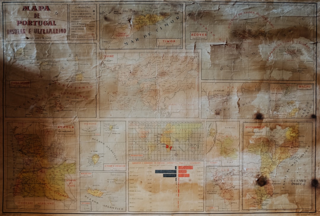
The Piri Reis Map, created in 1513, stands as a remarkable artifact in the history of cartography. This ancient map, attributed to the Ottoman admiral and cartographer Piri Reis, is renowned for its intricate details and the boldness of its claims regarding the geography of the world during the early 16th century. It is particularly famous for its depiction of parts of Europe, Africa, and the Americas, showcasing a level of geographical knowledge that was both advanced and controversial for its time.
The map not only serves as a testament to the navigational skills of the era but also raises questions about the sources of information available to cartographers in the Age of Exploration. The significance of the Piri Reis Map extends beyond mere geography; it encapsulates a moment in history when cultures were beginning to interact on a global scale. The map is a fusion of various sources, including ancient texts and firsthand accounts from explorers, which reflects the complex tapestry of knowledge that characterized the period.
As scholars and enthusiasts continue to study this remarkable document, it becomes increasingly clear that the Piri Reis Map is not just a navigational tool but a window into the past, revealing insights into the worldviews and aspirations of those who created it.
Key Takeaways
- The Piri Reis Map is a famous world map created by Ottoman-Turkish admiral and cartographer Piri Reis in 1513.
- The map is known for its accuracy and detailed depiction of coastlines, but also for its controversial inclusion of Antarctica.
- The controversy surrounding the map stems from the question of how Piri Reis could have known about the accurate coastline of Antarctica in the early 16th century.
- Modern analysis of the map’s accuracy suggests that it may have been based on older source material, possibly dating back to ancient civilizations.
- The Piri Reis Map has had a significant influence on cartography and continues to be the subject of modern interpretations and discoveries, debunking myths and misconceptions about its origins and purpose.
Historical Background of the Piri Reis Map
The creation of the Piri Reis Map occurred during a time of significant maritime exploration and expansion. The early 16th century was marked by European powers venturing into uncharted territories, driven by a desire for trade, conquest, and knowledge. Piri Reis himself was born in 1465 in what is now modern-day Turkey and served in the Ottoman navy.
His experiences at sea and his interactions with various cultures provided him with a unique perspective that he would later translate into his cartographic work. The map was drawn during a period when European nations were competing for dominance over newly discovered lands. The Spanish and Portuguese were particularly influential, having established vast empires in the Americas and beyond.
Piri Reis’s work reflects not only his own explorations but also the broader context of global exploration, where knowledge was often shared and adapted among different cultures. The historical backdrop against which the Piri Reis Map was created is essential for understanding its significance and the motivations behind its production.
The Controversy Surrounding the Piri Reis Map
The Piri Reis Map has been at the center of numerous controversies since its discovery. One of the most debated aspects is its depiction of South America and parts of Antarctica, which some claim suggests that Piri Reis had access to knowledge that was far ahead of his time. This has led to various theories, including speculations about lost civilizations or advanced ancient technologies that could have contributed to such detailed cartographic representations.
Critics argue that while the map is impressive, it should not be overstated. They contend that Piri Reis utilized existing maps and knowledge from earlier explorers, which may explain some of the map’s accuracy. The controversy surrounding the map often reflects broader themes in historical interpretation, where evidence can be viewed through different lenses depending on one’s perspective.
As scholars continue to analyze the map, they grapple with these conflicting interpretations, making it a focal point for discussions about historical accuracy and the evolution of cartography.
Analysis of the Piri Reis Map’s Accuracy
| Aspect | Details |
|---|---|
| Map Date | 1513 |
| Accuracy | Debate among scholars |
| Landmasses | Some accurately depicted, others distorted |
| Longitude and Latitude | Not accurately represented |
| Geographical Features | Some accurate, others speculative |
When examining the accuracy of the Piri Reis Map, it becomes evident that it is a complex blend of precise observations and artistic interpretation. The map features remarkably accurate depictions of coastlines and geographical features based on firsthand accounts from explorers who had ventured into these regions. For instance, the representation of the Brazilian coastline is notably detailed, suggesting that Piri Reis had access to reliable information from sailors who had navigated these waters.
However, there are also discrepancies that raise questions about its overall reliability. Some areas are depicted with exaggerated proportions or inaccuracies that reflect a lack of understanding or misinterpretation of certain geographical features. The map’s portrayal of Antarctica, for example, has sparked debates about whether Piri Reis had knowledge of this landmass before it was officially discovered in modern times.
This blend of accuracy and inaccuracy illustrates the challenges faced by cartographers in an era when exploration was still in its infancy.
The Source Material Used to Create the Piri Reis Map
Piri Reis’s methodology in creating his map involved synthesizing information from various sources, both ancient and contemporary. He explicitly noted that he drew upon earlier maps, including those from Greek and Roman geographers, as well as accounts from explorers who had traveled to new lands. This eclectic approach allowed him to create a map that was both innovative and reflective of existing knowledge.
One notable source cited by Piri Reis is Christopher Columbus’s voyages to the New World. The influence of Columbus’s discoveries is evident in how certain regions are depicted on the map. Additionally, Piri Reis incorporated information from Arab navigators and other European explorers, showcasing a collaborative spirit in cartography that transcended cultural boundaries.
This amalgamation of sources highlights not only Piri Reis’s skill as a cartographer but also the interconnectedness of knowledge during this transformative period in history.
The Geographic Significance of the Piri Reis Map
The geographic significance of the Piri Reis Map lies in its ability to bridge different worlds through its representation of landmasses and maritime routes. By depicting regions such as Europe, Africa, and parts of South America with relative accuracy, it served as a vital tool for navigation during an era when sea travel was fraught with uncertainty. The map provided sailors with essential information about coastlines, currents, and potential hazards, thereby enhancing their ability to traverse vast oceans.
Moreover, the map’s portrayal of newly discovered territories reflects a growing awareness among European powers about their place in a rapidly changing world. It symbolizes not only territorial claims but also cultural exchanges between different civilizations. The geographic significance extends beyond mere navigation; it encapsulates an era marked by exploration, conquest, and an evolving understanding of global geography.
The Cultural and Historical Context of the Piri Reis Map
To fully appreciate the Piri Reis Map, one must consider its cultural and historical context. The early 16th century was characterized by a burgeoning interest in exploration fueled by advancements in navigation technology and shipbuilding. This period saw European powers seeking new trade routes and territories, leading to encounters with diverse cultures across Africa and the Americas.
Piri Reis’s background as an Ottoman admiral adds another layer to this context. The Ottoman Empire was a significant player in global trade during this time, serving as a bridge between East and West. The map reflects not only European exploration but also the interconnectedness of various cultures and their contributions to knowledge.
It serves as a reminder that cartography is not merely a scientific endeavor but also a cultural artifact that embodies the values, aspirations, and interactions of different societies.
The Influence of the Piri Reis Map on Cartography
The influence of the Piri Reis Map on cartography cannot be overstated. It represents a pivotal moment in the evolution of map-making techniques and practices during the Age of Exploration. By integrating diverse sources and showcasing new geographical discoveries, it set a precedent for future cartographers who sought to create more accurate representations of the world.
Furthermore, the map’s artistic elements reflect a shift towards more visually engaging cartography. The use of vibrant colors and intricate designs not only served practical purposes but also appealed to aesthetic sensibilities. This emphasis on artistry would influence subsequent maps, as cartographers began to recognize the importance of visual representation in conveying geographical information effectively.
Modern Interpretations and Discoveries Related to the Piri Reis Map
In recent years, modern interpretations of the Piri Reis Map have led to exciting discoveries and renewed interest in its significance. Advances in technology have allowed researchers to analyze the map using digital tools, revealing hidden details and patterns that were previously overlooked.
Additionally, ongoing research has prompted scholars to revisit long-held assumptions about ancient navigation methods. Some theories suggest that ancient mariners possessed sophisticated techniques for mapping coastlines based on celestial navigation or oral traditions passed down through generations. These insights challenge conventional narratives about exploration and highlight the potential for further discoveries related to historical cartography.
Debunking Myths and Misconceptions about the Piri Reis Map
Despite its fame, numerous myths and misconceptions surround the Piri Reis Map that warrant clarification. One prevalent myth suggests that it contains evidence of advanced ancient civilizations with superior knowledge of geography long before modern exploration began. While it is true that the map showcases impressive detail for its time, attributing this accuracy solely to lost civilizations oversimplifies its creation process.
While some enthusiasts have speculated about secret meanings or prophecies contained within its lines and symbols, these interpretations often lack substantial evidence. By debunking these myths, scholars aim to foster a more nuanced understanding of the Piri Reis Map as a product of its time rather than an artifact shrouded in mystery.
The Legacy of the Piri Reis Map
The legacy of the Piri Reis Map endures as a symbol of human curiosity and exploration during a transformative period in history. Its intricate details and innovative approach to cartography continue to inspire scholars and enthusiasts alike. As researchers delve deeper into its origins and implications, they uncover layers of meaning that reflect not only geographical knowledge but also cultural exchanges between civilizations.
Ultimately, the Piri Reis Map serves as a reminder that maps are more than mere representations of land; they encapsulate stories, aspirations, and connections between people across time and space. Its enduring significance lies not only in its historical context but also in its ability to provoke questions about our understanding of geography and exploration today. As new discoveries emerge and interpretations evolve, the legacy of the Piri Reis Map will undoubtedly continue to shape discussions about cartography for generations to come.
The Piri Reis map, a fascinating artifact from the early 16th century, has intrigued historians and cartographers alike due to its detailed depiction of the world as known at that time. For a deeper understanding of the synthesis and significance of this remarkable map, you can explore a related article on the subject at