The vast, icy expanse of Greenland, a land often perceived as a monolithic frozen desert, holds secrets far more profound than surface observations might suggest. Beneath its ancient glaciers and permafrost lies a world of geological wonder, a testament to the powerful forces that shaped our planet. Exploring this hidden realm is a journey into Earth’s deep past and a crucial endeavor for understanding its future. It is a realm where bedrock meets ice, where geothermal heat battles glacial cold, and where scientific inquiry pushes the boundaries of human knowledge.
Greenland’s bedrock forms the unseen foundation upon which its iconic ice sheet rests. This ancient geological substrate is a complex tapestry, woven from some of the oldest rocks on Earth. For millennia, these rocks have been subjected to immense pressures, tectonic shifts, and the relentless sculpting power of glaciers. Understanding their composition and history is paramount to deciphering Greenland’s past and predicting its future behavior, particularly in the context of a warming climate.
The Archean and Proterozoic Roots
The majority of Greenland’s bedrock dates back to the Archean and Proterozoic eons, periods stretching from nearly 4 billion to 541 million years ago. These are the planet’s primordial stages, where the Earth’s crust was forming and early life was emerging. The Isua Greenstone Belt in southwestern Greenland, for instance, contains some of the oldest sedimentary rocks known, providing tantalizing clues about early Earth environments and the potential for ancient microbial life. These rocks have been intensely metamorphosed, meaning their original mineralogy and structure have been significantly altered by heat and pressure over eons. Studying them requires specialized techniques to unravel their deep history.
Unearthing Ancient Life and Early Biosignatures
Within these ancient rock formations, scientists search for biosignatures – evidence of past life. Stromatolites, layered structures formed by the activity of ancient microorganisms, have been identified in some of Greenland’s oldest rocks. While their interpretation can be complex, their presence in such ancient settings suggests that life may have been present on Earth much earlier than previously thought. The meticulous analysis of mineral composition, isotopic ratios, and microstructures within these rocks allows geologists to differentiate between biological and non-biological processes, a critical step in the hunt for extraterrestrial life.
Tectonic Plates and Continental Drift
Greenland’s geological narrative is also intrinsically linked to the grand story of plate tectonics. For millions of years, the landmass has been a part of larger continents, experiencing periods of rifting, collision, and separation. Evidence of these ancient tectonic events can be found in the patterns of fault lines, mountain ranges (now eroded and buried), and the types of rock formations present. Greenland’s position has shifted dramatically throughout geological time, influencing its climate and the development of its biological history. Understanding these continental movements helps to reconstruct past global geographies and predict future geological changes.
The Labrador Sea Rift System
A significant feature impacting Greenland’s geology is the Labrador Sea rift system. This zone of active spreading between Greenland and Canada was once a major site of continental breakup, leading to the formation of the Labrador Sea. The resulting crustal thinning and volcanic activity left a distinct geological signature on Greenland’s western coastline. Studying the remnants of this rift system provides insights into the mechanics of continental breakup and the formation of new ocean basins, processes that continue to shape our planet today.
Volcanic Activity and Intrusions
While Greenland is not currently known for active volcanism in the way of Iceland or Hawaii, its geological past is peppered with evidence of significant volcanic events. Ancient lava flows, volcanic ash deposits, and intrusive igneous bodies are found within its bedrock. These events, often linked to periods of rifting and increased heat from the Earth’s mantle, played a crucial role in shaping the landscape and influencing the mineralogy of the region. The presence of certain mineral deposits can often be traced back to these ancient volcanic episodes.
The Exploitation of Mineral Wealth
The geological processes that shaped Greenland’s bedrock have also led to the accumulation of valuable mineral resources. While large-scale mining is limited, the potential for significant mineral deposits, including rare earth elements, iron, zinc, and even diamonds, is recognized. Scientific exploration of the bedrock’s composition is key to identifying areas with high mineral potential, though ethical and environmental considerations are paramount in any discussion of exploitation. The hidden wealth within Greenland’s core represents a complex interplay between geological processes and the potential for human resource utilization.
The exploration of the hidden world beneath Greenland has unveiled fascinating insights into climate change and its impact on global sea levels. For further reading on related environmental issues, you can check out the article on disappearing countries and the global crisis they face, which highlights the urgent need for action in response to rising sea levels. To learn more, visit this article.
The Subglacial Water Realm: Rivers, Lakes, and Ocean Inlets
Beneath the vast ice sheet lies a dynamic and largely unexplored aquatic world. Meltwater, generated by the geothermal heat from below and friction from ice movement, carves intricate networks of rivers and carves out vast subglacial lakes. These liquid arteries and reservoirs are not only vital for the hydrological cycle of the ice sheet but also hold clues about its stability and potential contribution to sea-level rise. The interface between ice and water is a critical zone of interaction, influencing the dynamics of glacial flow and the overall health of the ice sheet.
Subglacial Lakes: Hidden Aquatic Ecosystems?
The discovery of subglacial lakes, some the size of major terrestrial lakes, has been one of the most significant findings in recent glaciological research. Lake Vostok in Antarctica is a famous example, but Greenland also harbors its own hidden bodies of water. These lakes are formed in depressions in the bedrock where the ice sheet’s weight is less, or where geothermal heat melts the ice from below. Their isolation for millennia raises exciting questions about the possibility of unique, extremophile ecosystems adapted to life in perpetual darkness, high pressure, and freezing temperatures.
Sampling the Depths: Challenges and Discoveries
Accessing these subglacial lakes is an immense logistical and technological challenge. Scientists have developed specialized drilling techniques that use hot water or sterile drill bits to penetrate the thick ice without contaminating the pristine water below. The retrieved water samples can then be analyzed for their chemistry, for the presence of microorganisms, and for any preserved organic material. These expeditions are at the forefront of scientific exploration, pushing the boundaries of what is possible in extreme environments.
Subglacial Rivers and Their Glacial Flow Influence
Subglacial rivers are the conveyor belts of meltwater, transporting it from where it forms to where it exits the ice sheet. These powerful waterways are not static; their paths can shift, and their flow rates can fluctuate dramatically. The speed and volume of these rivers play a crucial role in lubricating the base of the ice sheet, influencing how quickly the ice flows towards the ocean. Understanding these subglacial hydrological systems is therefore essential for accurately modeling ice sheet behavior and predicting sea-level rise.
Mapping the Unseen Waterways
Techniques like ice-penetrating radar, seismic surveys, and the analysis of GPS data from the ice surface are used to map these hidden river systems. By observing how the ice sheet deforms and moves, scientists can infer the presence and pathways of these subglacial rivers. This knowledge is vital for understanding the complex mechanics of glacial drainage and how meltwater impacts the stability of the ice.
Ice-Ocean Interactions: Fjords and Submarine Melt
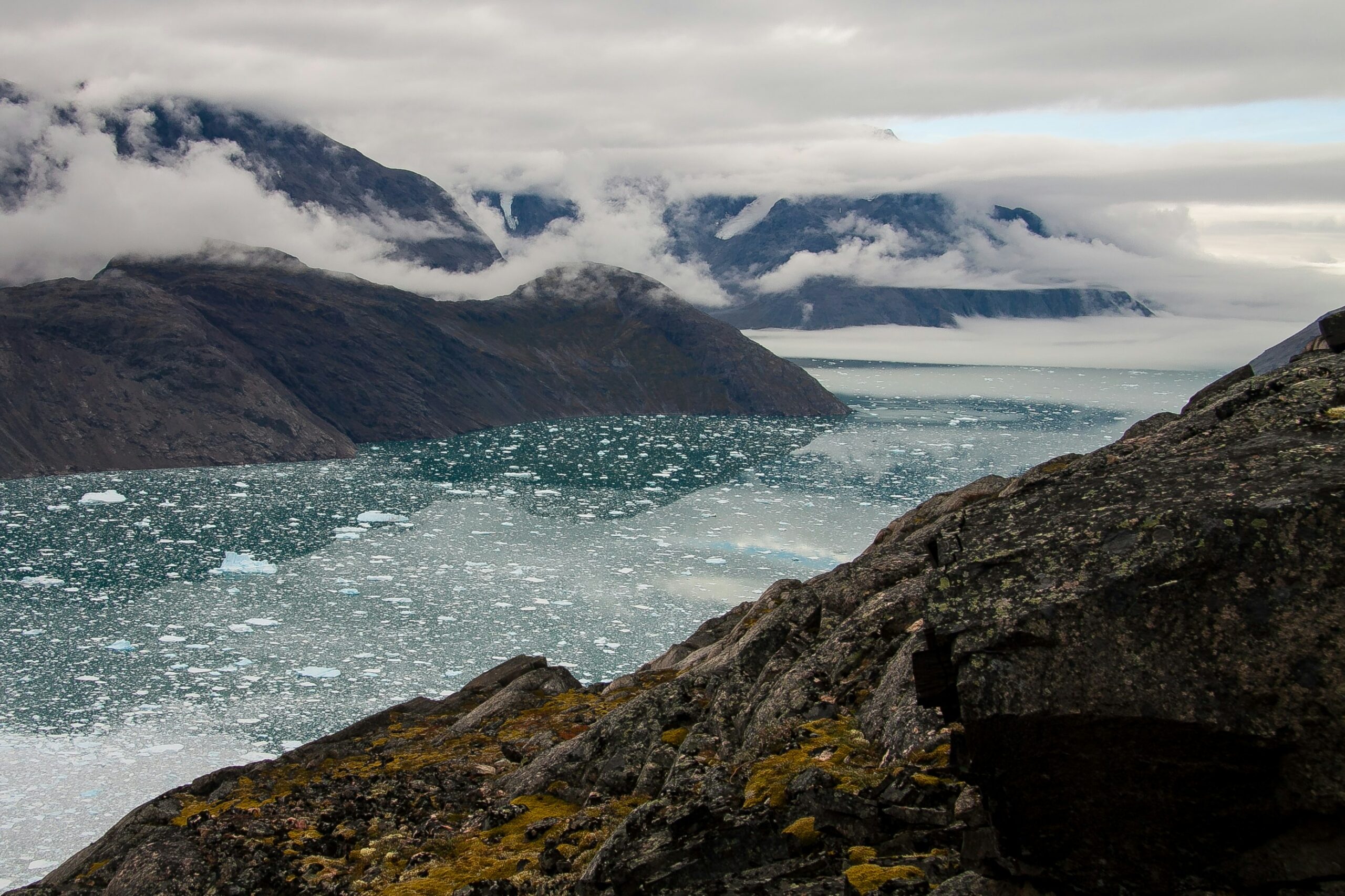
Greenland’s fjords, carved by glaciers over millennia, are dynamic conduits where glacial ice meets the salty ocean. Here, a critical process occurs: submarine melt. Warmer ocean waters circulating beneath the ice shelves and ice margins can melt the ice from below, contributing significantly to ice loss. Understanding the complex exchange of heat and freshwater at the ice-ocean boundary is crucial for predicting Greenland’s contribution to future sea-level rise.
The Impact of Ocean Warming on Ice Shelves
As global ocean temperatures rise, the impact on Greenland’s ice shelves and outlet glaciers becomes increasingly acute. Warmer waters accelerate submarine melt, leading to thinning and destabilization of these critical ice formations. This can, in turn, speed up the flow of the inland ice towards the sea. Studying the intricate dynamics of these ice-ocean interactions requires sophisticated oceanographic and glaciological measurements, often conducted from research vessels or by deploying instruments directly into the frigid waters.
The Subglacial Topography: A Landscape Under Ice
The surface of Greenland is dominated by ice, but beneath it lies a varied and dramatic topography. The bedrock is not a uniformly flat plain; it features mountains, valleys, and depressions that have been sculpted by millions of years of glacial erosion. This subglacial landscape plays a profound role in directing the flow of ice and determining the eventual fate of the ice sheet. Mapping this hidden terrain is a testament to persistent scientific inquiry and advanced technology.
Mountains and Valleys: Guiding the Ice Flow
Inland, Greenland’s bedrock hides mountain ranges and deep valleys. These features act as natural guides, channeling the immense forces of the ice sheet. Glaciers tend to flow faster through valleys and can be slowed or diverted by mountain ranges. Understanding the precise shape of the subglacial topography is essential for creating accurate models of ice flow dynamics. A seemingly insignificant depression can become a conduit for ice, while a prominent ridge can act as a significant barrier.
Radar Imaging and its Revelations
Ice-penetrating radar is the primary tool for revealing Greenland’s subglacial topography. By sending radio waves through the ice and measuring the time it takes for them to return after reflecting off the bedrock, scientists can create detailed maps of the unseen landscape. These radar surveys have unveiled vast river valleys, ancient mountain ranges, and deep basins, completely reshaping our understanding of Greenland’s internal structure.
Ice Sheet Basins and Depressions
Certain areas of Greenland’s bedrock lie at elevations significantly below sea level. These deep basins can trap ice and influence its accumulation and flow patterns. Some of these basins have been submerged by the ocean in the past, and their geological history is intertwined with periods of deglaciation and sea-level change. Studying these features provides insights into past climatic conditions and the long-term stability of the ice sheet.
Historical Sea-Level Changes and Submerged Features
The presence of submerged bedrock features can indicate past periods when sea levels were higher and parts of Greenland were under the ocean. Analyzing the sediments and geological formations within these basins can reveal evidence of past marine life and provide clues about the extent of previous ice sheets. This historical perspective is invaluable for understanding how the ice sheet might respond to future sea-level rise.
Permafrost and its Hidden Secrets: A Changing Frontier

While the focus is often on the ice sheet, a significant portion of Greenland’s bedrock is also covered by permafrost – ground that has remained frozen for at least two consecutive years. This vast frozen layer holds immense quantities of ancient organic material, including plants, animals, and even microbes. As global temperatures rise, this permafrost is thawing, revealing its secrets and posing significant environmental challenges. Exploring this thawing frontier is a race against time.
Ancient Organic Matter: A Record of Past Ecosystems
Within the permafrost lie preserved remnants of past ecosystems. Plant roots, seeds, insect exoskeletons, and animal remains offer a snapshot of Greenland’s environment prior to its current glaciated state. Analyzing this preserved organic matter can provide detailed information about past climates, vegetation, and biodiversity, essentially acting as a frozen archive of ecological history.
Paleobotany and Paleozoology in the Thawing Ground
Scientists are diligently collecting and studying these ancient biological samples. Paleobotanists reconstruct past environments by analyzing plant remains, while paleozoologists study animal fossils. This work sheds light on how plant and animal communities have responded to climate change throughout Earth’s history, offering valuable context for understanding current ecological shifts.
Carbon and Methane Release: A Climate Feedback Loop
One of the most significant concerns associated with thawing permafrost is the release of stored carbon and methane. As the frozen ground thaws, organic matter decomposes, releasing greenhouse gases into the atmosphere. Methane, in particular, is a potent greenhouse gas. This release creates a positive feedback loop, where warming leads to thawing, which leads to more greenhouse gas emissions, further accelerating warming. Understanding the scale and rate of this release is crucial for climate modeling.
Quantifying Greenhouse Gas Emissions
Researchers employ various methods to quantify the release of carbon dioxide and methane from thawing permafrost. This involves monitoring gas fluxes from the land surface, analyzing gas compositions in core samples, and simulating decomposition rates under different temperature scenarios. The collected data is vital for informing global climate projections and mitigation strategies.
The Potential for Ancient Microbes and Viruses
The thawing of permafrost also raises concerns about the potential release of ancient, dormant microbes and viruses. While the risk of widespread pandemics from these thawed organisms is considered low, the possibility exists. Scientists are actively studying these microbes to understand their viability and potential impact, while also developing strategies for safe sampling and containment. This area of research walks a delicate line between scientific curiosity and public health preparedness.
Recent discoveries about the hidden world beneath Greenland have sparked interest in the geological and environmental implications of such vast ice-covered regions. This fascinating topic is further explored in an article that discusses the militarization of celestial bodies and the strategic advantages that come with understanding our planet’s hidden features. For a deeper insight into how these developments may influence global dynamics, you can read more in this article about the militarization of the moon.
The Future of Greenland’s Hidden World: Climate Change and Scientific Discovery
| Metrics | Data |
|---|---|
| Ice Thickness | Up to 3 kilometers |
| Subglacial Lakes | More than 50 |
| Ice Temperature | As low as -20 degrees Celsius |
| Subglacial Streams | Flowing beneath the ice |
The exploration of Greenland’s hidden world is not merely an academic pursuit; it is inextricably linked to the profound changes occurring due to climate change. The melting of the ice sheet, the thawing of permafrost, and the warming of ocean waters are all interconnected phenomena that demand urgent scientific attention and continued exploration of the subglacial realm.
Ice Sheet Dynamics and Sea-Level Rise Projections
The future of Greenland’s ice sheet is a critical component of global sea-level rise projections. Understanding how the ice sheet is responding to warming temperatures – its rate of melting, its ice flow dynamics, and the influence of subglacial water systems – is paramount. Scientists continuously monitor these changes using a combination of satellite observations, ground-based surveys, and sophisticated modeling techniques. The hidden world beneath the ice holds vital clues to these future predictions.
Advanced Modeling and Data Integration
The integration of data from various sources, including radar surveys, seismic data, GPS measurements, and oceanographic data, is crucial for building accurate predictive models of ice sheet behavior. These models are constantly being refined as new discoveries are made about the complexities of the subglacial environment. Understanding how the bedrock topography, subglacial water systems, and ocean temperatures interact is key to improving these projections.
Geothermal Energy and Resource Potential
While the direct exploitation of geothermal energy in Greenland is currently limited, the presence of a geologically active region beneath the ice suggests potential for future development. Understanding the heat flow from the Earth’s interior is part of the broader exploration of Greenland’s hidden world. Furthermore, the identification of mineral resources, as discussed earlier, is also a significant aspect of the future potential that lies beneath the ice.
Sustainable Exploration and Resource Management
Any future resource development in Greenland must be approached with extreme caution and a commitment to sustainability. The sensitive Arctic environment and the unique geological features require careful planning and rigorous environmental impact assessments. Scientific exploration provides the foundational knowledge to inform responsible decision-making regarding the exploitation of both energy and mineral resources.
International Collaboration and Technological Innovation
Exploring the hidden world beneath Greenland is a global scientific endeavor that relies heavily on international collaboration and continuous technological innovation. Researchers from around the world share data, expertise, and resources to tackle the immense challenges of studying this remote and extreme environment. Advancements in satellite technology, drilling techniques, sensor development, and data processing are constantly pushing the boundaries of what is possible. The ongoing quest to understand Greenland’s hidden depths is a testament to human curiosity and our drive to uncover the planet’s deepest secrets, with implications that extend far beyond its icy shores.

This Crater Was Supposed to Rewrite Human History… It Didn’t
FAQs
What is the hidden world beneath Greenland?
The hidden world beneath Greenland refers to a vast network of rivers and lakes that exist beneath the ice sheet covering the island. These water systems are formed by meltwater from the ice sheet and play a crucial role in shaping the landscape and influencing ice flow.
How were these hidden water systems discovered?
Scientists have used satellite and aerial data, as well as ground-based radar and seismic measurements, to map the subglacial water systems beneath Greenland. This research has provided valuable insights into the dynamics of the ice sheet and its potential impact on sea level rise.
What is the significance of the hidden world beneath Greenland?
The hidden water systems beneath Greenland have significant implications for understanding the behavior of the ice sheet and its contribution to sea level rise. They also play a role in lubricating the base of the ice sheet, which can affect the speed at which the ice flows towards the ocean.
How does the hidden world beneath Greenland impact the environment?
The presence of subglacial water systems beneath Greenland can influence the stability of the ice sheet and contribute to the acceleration of ice flow towards the ocean. This can ultimately lead to increased sea level rise and have broader implications for global climate and coastal communities.
What are the ongoing research efforts related to the hidden world beneath Greenland?
Scientists continue to study the hidden water systems beneath Greenland to better understand their dynamics and potential impact on the environment. Ongoing research efforts include using advanced technologies to map and monitor subglacial water systems, as well as modeling their interactions with the ice sheet.