Ancient maps serve as a fascinating window into the past, revealing the geographical understanding and cultural perspectives of early civilizations. These artifacts, often crafted with meticulous care, reflect not only the physical landscapes of their time but also the beliefs, values, and priorities of the societies that created them. From the clay tablets of Mesopotamia to the intricate scrolls of ancient Greece, maps have played a crucial role in navigation, trade, and the dissemination of knowledge.
They are more than mere representations of land; they encapsulate the essence of human curiosity and the desire to comprehend the world. The study of ancient maps offers insights into how different cultures perceived their environment and organized their knowledge. Each map tells a story, revealing the interplay between geography and human experience.
As scholars delve into these historical documents, they uncover layers of meaning that extend beyond cartography, touching on themes of exploration, conquest, and cultural exchange. The significance of ancient maps lies not only in their artistic merit but also in their ability to connect contemporary audiences with the thoughts and aspirations of those who lived millennia ago.
Key Takeaways
- Ancient maps demonstrate surprisingly precise geographic knowledge and navigational accuracy.
- Early civilizations used advanced astronomy and mathematics to enhance map accuracy.
- The techniques and origins of ancient mapmaking remain partly mysterious and debated.
- Ancient maps have significantly influenced the development of modern cartography.
- Preserving and studying these maps is crucial for understanding cultural and historical contexts.
The Puzzling Precision of Ancient Cartography
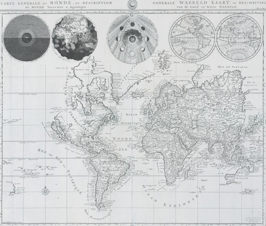
The precision exhibited in ancient cartography is both remarkable and puzzling. Despite the rudimentary tools available to early mapmakers, many ancient maps display an astonishing level of accuracy that continues to baffle historians and geographers alike. For instance, the Ptolemaic maps from the second century AD demonstrate a sophisticated understanding of latitude and longitude, showcasing a level of detail that suggests a deep engagement with the natural world.
This precision raises questions about how ancient civilizations gathered and processed geographical information without the advanced technology available today. Moreover, the methods employed by these early cartographers often involved a combination of observation, oral tradition, and empirical data collection. They relied on travelers’ accounts, astronomical observations, and even mythological narratives to create their maps.
This blend of science and storytelling reflects a unique approach to understanding geography that transcends mere representation. The resulting maps not only served practical purposes but also conveyed cultural narratives, illustrating how ancient peoples navigated both their physical and metaphysical worlds.
The Astonishing Geographic Knowledge of Early Civilizations
Early civilizations possessed an astonishing breadth of geographic knowledge that belied their technological limitations. The Egyptians, for example, demonstrated an impressive understanding of their surroundings, as evidenced by their detailed maps of the Nile River and surrounding regions. These maps were not only practical for navigation but also held religious significance, reflecting the Egyptians’ reverence for the life-giving waters of the Nile.
Similarly, the Greeks contributed significantly to geographic knowledge through figures like Eratosthenes, who calculated the Earth’s circumference with remarkable accuracy. The geographic knowledge of these civilizations was often intertwined with their cultural identities. The Chinese, for instance, developed intricate maps that reflected their worldview, emphasizing harmony with nature and the importance of balance in their environment.
This cultural lens shaped their cartographic practices, leading to maps that were as much about philosophy as they were about geography. Such insights reveal that ancient mapmaking was not merely a technical endeavor; it was deeply rooted in the cultural fabric of each society.
The Mysterious Techniques Used to Create Ancient Maps
The techniques employed in ancient mapmaking remain shrouded in mystery, as many methods have been lost to time. However, scholars have pieced together various approaches that early cartographers may have used to create their works. One common technique involved triangulation, where mapmakers would use known points in the landscape to determine distances and angles.
This method allowed for a more accurate representation of terrain and distances than might be expected from such early periods. Additionally, ancient mapmakers often relied on celestial navigation to inform their work. By observing the stars and celestial bodies, they could establish directions and distances with surprising accuracy.
This reliance on astronomy highlights the interconnectedness of various fields of study in ancient times; geography, mathematics, and astronomy were not seen as separate disciplines but rather as complementary aspects of understanding the world. The synthesis of these techniques resulted in maps that were not only functional but also reflective of a sophisticated intellectual tradition.
The Unbelievable Accuracy of Ancient Navigational Charts
| Map Name | Era | Region Covered | Estimated Accuracy (%) | Notable Inaccuracies | Reason for Inaccuracy |
|---|---|---|---|---|---|
| Ptolemy’s World Map | 2nd Century AD | Europe, North Africa, Asia | 60 | Distorted Asia and Africa coastlines | Limited exploration and measurement tools |
| Tabula Peutingeriana | 4th Century AD | Roman Empire road network | 50 | Non-proportional distances, schematic layout | Focus on routes over geographic accuracy |
| Hereford Mappa Mundi | 13th Century | World (Medieval European view) | 30 | Religious and mythical elements dominate | Lack of scientific cartography, symbolic representation |
| Mercator’s World Map | 1569 | Global | 75 | Distorted polar regions | Projection method prioritizes navigation over area accuracy |
| Fra Mauro Map | 1450 | Europe, Asia, Africa | 65 | Inaccurate depiction of southern hemisphere | Limited knowledge of southern continents |
Navigational charts from ancient civilizations exhibit an unbelievable level of accuracy that challenges modern assumptions about early seafaring capabilities. The Polynesians, for instance, are renowned for their exceptional navigational skills across vast oceanic expanses using star patterns, ocean swells, and bird migrations as guides. Their intricate stick charts represented these navigational principles and demonstrated a profound understanding of their maritime environment.
Similarly, the Vikings utilized advanced navigational techniques that allowed them to traverse treacherous waters with remarkable precision. Their use of landmarks, sun compasses, and even the position of the sun during different times of the year enabled them to navigate effectively across the North Atlantic.
The Enigmatic Origins of Ancient Mapmaking
The origins of ancient mapmaking remain enigmatic, with various theories attempting to explain how this practice began. Some scholars suggest that early humans created rudimentary maps as a means of recording hunting grounds or migratory routes. These early representations may have been simple sketches etched into stone or drawn in sand, serving as practical tools for survival in a challenging environment.
As societies evolved and became more complex, so too did their mapping practices. The emergence of writing systems allowed for more sophisticated representations of geography, leading to the creation of detailed maps on clay tablets or parchment. This transition marked a significant shift in how humans interacted with their environment; maps became not only tools for navigation but also symbols of power and knowledge within emerging civilizations.
The Role of Astronomy and Mathematics in Ancient Map Accuracy
Astronomy and mathematics played pivotal roles in enhancing the accuracy of ancient maps. Early cartographers often relied on celestial bodies to establish coordinates and directions, using stars as fixed points for navigation. This reliance on astronomy was particularly evident in cultures such as the Babylonians and Greeks, who meticulously observed celestial movements to inform their geographic understanding.
Mathematics also contributed significantly to map accuracy through techniques such as geometry and trigonometry. Ancient mathematicians developed methods for calculating distances and angles that were essential for creating accurate representations of landforms and territories. The integration of these disciplines into cartography underscores the intellectual rigor present in ancient societies; they approached mapmaking as a scientific endeavor grounded in observation and calculation.
The Legacy of Ancient Maps on Modern Cartography
The legacy of ancient maps continues to influence modern cartography in profound ways. Many contemporary mapping techniques can trace their roots back to practices established by early civilizations. For instance, the use of grid systems in modern maps can be linked to Ptolemaic innovations in coordinate systems that sought to standardize geographic representation.
Furthermore, ancient maps have inspired modern artists and designers who draw upon historical styles and techniques to create visually compelling representations of space. The aesthetic qualities found in ancient cartography—such as intricate illustrations and decorative elements—remain relevant today as cartographers strive to balance functionality with artistic expression. This enduring legacy highlights how ancient practices continue to shape contemporary understandings of geography.
The Debate Surrounding the Accuracy of Ancient Maps
Despite their remarkable achievements, debates surrounding the accuracy of ancient maps persist among scholars. Critics argue that many ancient representations were influenced by mythological beliefs or political agendas rather than empirical observation. For example, some maps depicted fantastical creatures or exaggerated landforms that reflected cultural narratives rather than geographical realities.
Conversely, proponents assert that while some inaccuracies exist, many ancient maps demonstrate a surprising level of precision that challenges modern perceptions of early cartographic capabilities. They argue that these maps should be viewed within their historical context; what may appear inaccurate by today’s standards could have been considered highly accurate at the time they were created. This ongoing debate underscores the complexity of interpreting ancient maps and highlights the need for continued research into their historical significance.
The Cultural and Historical Significance of Ancient Maps
Ancient maps hold immense cultural and historical significance beyond their practical applications. They serve as artifacts that encapsulate the values, beliefs, and aspirations of societies long gone. For instance, maps created during the Age of Exploration reflect not only geographical knowledge but also imperial ambitions and cultural encounters between different civilizations.
Moreover, ancient maps often reveal insights into trade routes, migration patterns, and territorial disputes that shaped historical events. They provide a visual narrative that complements written records, offering a more nuanced understanding of how people interacted with their environment over time. As such, these maps are invaluable resources for historians seeking to reconstruct past societies and comprehend their complexities.
The Future of Studying and Preserving Ancient Maps
The future of studying and preserving ancient maps is bright yet fraught with challenges. As technology advances, new methods for digitizing and analyzing these artifacts are emerging, allowing scholars to explore previously inaccessible details within ancient cartography. Digital mapping tools enable researchers to overlay historical maps onto contemporary landscapes, facilitating comparative studies that enhance our understanding of geographic change over time.
However, preserving physical artifacts remains a critical concern as many ancient maps are vulnerable to deterioration due to environmental factors or improper handling. Institutions dedicated to archiving these treasures must prioritize conservation efforts while also making them accessible to researchers and the public alike. By fostering interdisciplinary collaboration among historians, cartographers, and conservationists, future generations can continue to unravel the mysteries embedded within ancient maps while ensuring their preservation for years to come.
In conclusion, ancient maps are not merely relics from a bygone era; they are vital links connecting humanity’s past with its present and future.
The accuracy of ancient maps has long been a topic of fascination and debate among historians and cartographers. While many ancient civilizations created intricate maps, the limitations of their knowledge and technology often resulted in inaccuracies. For a deeper exploration of this subject, you can read more in the article available at Real Lore and Order, which discusses the challenges and methodologies behind ancient cartography.
WATCH THIS! 🗺️ The Map That Proves Humans Explored Earth 5,000 Years Too Early
FAQs
What is meant by the accuracy of ancient maps?
The accuracy of ancient maps refers to how closely these maps represent the true geographical features, distances, and spatial relationships of the areas they depict, based on modern measurements and knowledge.
Why is it considered impossible for ancient maps to be fully accurate?
Ancient maps are considered impossible to be fully accurate because early cartographers lacked advanced tools like GPS, satellite imagery, and precise surveying instruments. Their knowledge was often based on exploration, hearsay, and limited measurement techniques, leading to distortions and inaccuracies.
What methods did ancient mapmakers use to create their maps?
Ancient mapmakers used methods such as direct observation, compass directions, estimated distances, astronomical observations, and reports from travelers and traders. They often combined these with artistic interpretation and symbolic representation.
Are there any ancient maps that are surprisingly accurate?
Yes, some ancient maps, such as the Ptolemaic maps or the Peutinger Table, show remarkable accuracy for their time, especially in depicting coastlines and major landmarks. However, even these maps contain distortions and errors by modern standards.
How did the limitations of ancient technology affect map accuracy?
Limitations such as the absence of precise measuring tools, lack of standardized units, and difficulties in determining longitude and latitude led to errors in scale, orientation, and placement of features on ancient maps.
Can ancient maps still be useful today despite their inaccuracies?
Yes, ancient maps are valuable for understanding historical perspectives, trade routes, cultural exchanges, and the development of geographic knowledge. They provide insights into how ancient civilizations viewed their world.
What role did myths and legends play in ancient mapmaking?
Myths and legends often influenced ancient maps by including imaginary places, creatures, or exaggerated features, reflecting the cultural beliefs and limited knowledge of the time rather than factual geography.
How has modern technology improved map accuracy compared to ancient times?
Modern technology such as satellite imagery, GPS, aerial photography, and computer modeling allows for precise measurement and representation of the Earth’s surface, resulting in highly accurate and detailed maps.
Is it possible to correct or update ancient maps with modern data?
While ancient maps themselves cannot be changed, researchers can overlay modern geographic data onto them to analyze discrepancies, understand historical contexts, and create updated versions that combine historical and current information.
Why do some people believe ancient maps are more accurate than modern science suggests?
Some believe ancient maps are more accurate due to interpretations of certain map features that seem to depict unknown or advanced knowledge. However, these claims are often speculative and not supported by mainstream scientific evidence.