
The history of ancient cartography is a fascinating journey that traces the evolution of map-making from rudimentary sketches to sophisticated representations of the world. The earliest known maps date back to the Babylonian civilization around 600 BCE, where clay tablets depicted the surrounding regions and celestial bodies. These early maps were not merely practical tools; they were also imbued with cultural significance, reflecting the beliefs and values of the societies that created them.
As civilizations advanced, so too did their cartographic techniques, leading to more accurate and detailed representations of geography. In ancient Greece, cartography underwent a significant transformation, largely due to the contributions of scholars like Anaximander and Ptolemy. Anaximander is often credited with creating one of the first world maps, which depicted a flat Earth surrounded by water.
Ptolemy’s work, “Geographia,” compiled knowledge from various sources and introduced a coordinate system that laid the groundwork for modern mapping. This period marked a shift from mythological representations of the world to more empirical approaches, as cartographers began to rely on observation and measurement to create their maps.
Key Takeaways
- Ancient cartography dates back to as early as the 6th century BCE, with maps being created by civilizations such as the Greeks, Romans, and Chinese.
- Cartography played a crucial role in ancient civilizations, aiding in navigation, trade, and the establishment of empires.
- Ancient maps hold many mysteries, including inaccuracies, mythical creatures, and unexplored territories, providing insight into the beliefs and knowledge of the time.
- Forbidden knowledge in ancient cartography includes maps with hidden symbols, secret routes, and knowledge deemed dangerous by ruling powers.
- The suppression of ancient cartographic knowledge occurred through the destruction of maps, censorship, and the withholding of information by those in power.
The Role of Cartography in Ancient Civilizations
Cartography played a crucial role in the development and expansion of ancient civilizations. Maps served not only as navigational aids but also as tools for political power and territorial claims. In ancient Egypt, for instance, maps were used to delineate land ownership and manage resources along the Nile River.
Their maps reflected not only geographical features but also the socio-political landscape, illustrating the interconnectedness of geography and governance. Similarly, in ancient Rome, cartography was integral to the empire’s expansion and administration.
Roman maps, such as the Tabula Rogeriana created by the geographer Muhammad al-Idrisi in the 12th century, provided detailed information about roads, cities, and trade routes. These maps facilitated military campaigns and economic activities, allowing for efficient movement of troops and goods across vast distances. The Romans understood that accurate maps were essential for maintaining control over their territories, highlighting the strategic importance of cartography in ancient governance.
The Mysteries of Ancient Maps
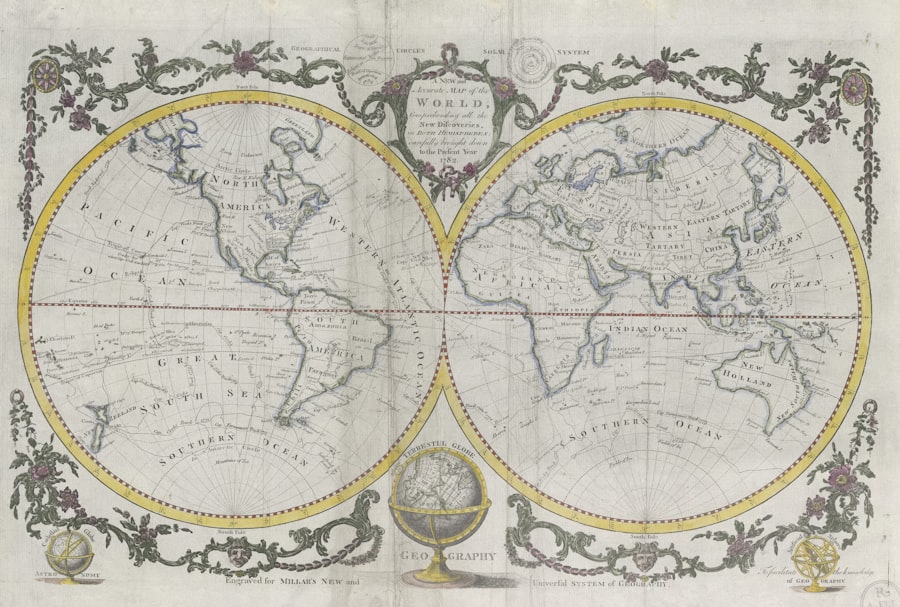
Ancient maps are often shrouded in mystery, with many containing symbols and markings that remain enigmatic to modern scholars. For instance, the Mappa Mundi, a medieval European map, depicts not only geographical features but also mythological creatures and religious symbols. Such elements raise questions about the intentions behind these maps and the knowledge systems of their creators.
The presence of fantastical elements suggests that ancient cartographers blended empirical observation with cultural narratives, creating maps that served both practical and symbolic purposes. Another intriguing aspect of ancient maps is their representation of unknown territories. Many ancient civilizations created maps that included regions beyond their known world, often filled with imaginative depictions of monsters or uncharted lands.
This practice reflects humanity’s innate curiosity and desire to explore the unknown. The existence of these mysterious regions on ancient maps invites speculation about what lay beyond the horizon and how these representations influenced exploration and trade.
Forbidden Knowledge in Ancient Cartography
| Map | Forbidden Knowledge | Ancient Source |
|---|---|---|
| Piri Reis Map | Depiction of Antarctica before discovery | Drawn in 1513 by Piri Reis |
| Orontius Finaeus Map | Shows Antarctica without ice | Created in 1531 by Orontius Finaeus |
| Babylonian Map of the World | Depicts mythical creatures and gods | Created in the 6th century BCE |
The concept of forbidden knowledge in ancient cartography is a compelling theme that intertwines with the history of exploration and discovery. Certain maps contained information that was considered too sensitive or dangerous for public dissemination. For example, during the Age of Exploration, European powers often kept detailed maps of newly discovered territories secret to maintain their competitive advantage over rivals.
This practice highlights how cartography was not merely a scientific endeavor but also a tool for power dynamics and geopolitical strategy. Moreover, some ancient texts hinted at lost civilizations or advanced knowledge that was deliberately obscured or forgotten over time. The existence of maps that depicted places like Atlantis or other mythical lands raises questions about what ancient cultures may have known about geography and civilization that has since been lost.
The allure of forbidden knowledge continues to captivate historians and adventurers alike, as they seek to uncover hidden truths about our past.
The Suppression of Ancient Cartographic Knowledge
Throughout history, there have been instances where ancient cartographic knowledge was suppressed or lost due to political or religious motivations. The fall of empires often led to the destruction of libraries and archives containing valuable maps and geographical information. For example, the burning of the Library of Alexandria in 48 BCE resulted in the loss of countless works, including those related to cartography.
This event marked a significant setback in the preservation of ancient knowledge and illustrates how political turmoil can disrupt the continuity of scientific progress. In addition to physical destruction, ideological suppression also played a role in the loss of cartographic knowledge. During certain periods, religious authorities deemed specific geographical ideas heretical or contrary to established beliefs.
This led to censorship and the alteration of maps to align with prevailing doctrines. Such actions not only stifled intellectual inquiry but also shaped how future generations understood their world, demonstrating the profound impact of power on knowledge dissemination.
Decoding Ancient Maps: Uncovering Hidden Secrets
Decoding ancient maps is an intricate process that requires a multidisciplinary approach involving historians, archaeologists, and cartographers. Scholars meticulously analyze symbols, scales, and orientations to glean insights into the cultural context in which these maps were created. For instance, examining the orientation of a map can reveal how its creators perceived their world—whether they prioritized cardinal directions or local landmarks.
Moreover, advancements in technology have enabled researchers to uncover hidden layers within ancient maps. Techniques such as multispectral imaging allow for the visualization of faded inscriptions or markings that may have been overlooked by the naked eye. These discoveries can lead to new interpretations and a deeper understanding of historical events or geographical knowledge that was once thought lost.
The process of decoding ancient maps is akin to piecing together a puzzle, where each fragment contributes to a larger narrative about humanity’s relationship with geography.
The Influence of Ancient Cartography on Modern Mapping Techniques
The legacy of ancient cartography continues to influence modern mapping techniques in profound ways. Many principles established by early cartographers remain relevant today, such as scale representation and coordinate systems. The work of figures like Ptolemy laid the groundwork for contemporary geographic information systems (GIS), which rely on similar concepts for spatial analysis and mapping.
Furthermore, modern cartographers often draw inspiration from ancient styles and methods when creating thematic or artistic maps. The aesthetic qualities found in historical maps—such as intricate illustrations and decorative elements—are sometimes incorporated into contemporary designs to evoke a sense of nostalgia or cultural heritage. This blending of old and new reflects an ongoing dialogue between past practices and present innovations in cartography.
The Cultural and Spiritual Significance of Ancient Maps
Ancient maps held deep cultural and spiritual significance for many civilizations. They were not merely tools for navigation; they often embodied cosmological beliefs and societal values. For instance, in many indigenous cultures, maps served as sacred representations of their relationship with the land, integrating spiritual narratives with geographical features.
These maps conveyed stories about creation, ancestry, and identity, reinforcing communal ties to specific locations. In addition to their cultural importance, ancient maps also played a role in shaping worldviews. The way a civilization represented its environment could reflect its understanding of order, chaos, and the divine.
For example, medieval European maps often placed Jerusalem at the center, symbolizing its spiritual significance in Christianity. Such representations reveal how geography was intertwined with belief systems, illustrating how maps functioned as both practical tools and expressions of cultural identity.
The Power and Politics of Ancient Cartography
The interplay between power and politics in ancient cartography is evident throughout history. Maps were often used as instruments of control, enabling rulers to assert dominance over territories and populations. By depicting borders and resources, cartographers provided visual evidence that legitimized claims to land ownership or sovereignty.
This practice was particularly pronounced during periods of colonization when European powers sought to map newly acquired territories as a means of asserting authority. Moreover, the manipulation of cartographic information could serve propaganda purposes. Rulers would commission maps that exaggerated their territories or downplayed rival claims to bolster their legitimacy.
This strategic use of cartography highlights its role as a tool for shaping public perception and influencing political narratives. As such, ancient maps were not just reflections of reality; they were active participants in the construction of power dynamics.
The Quest for Lost and Forbidden Maps
The quest for lost and forbidden maps has captivated explorers, historians, and treasure hunters alike throughout history. Tales of hidden treasures or secret knowledge often accompany legends surrounding these elusive artifacts.
This fascination has spurred numerous expeditions aimed at uncovering these hidden treasures. From searching for lost cities like El Dorado to seeking out mythical places described in ancient texts, adventurers have pursued these elusive goals with fervor. The allure of forbidden maps lies not only in their potential discoveries but also in their ability to connect individuals with a sense of adventure and exploration that transcends time.
Preserving and Protecting Ancient Cartographic Knowledge
Preserving ancient cartographic knowledge is essential for understanding humanity’s historical relationship with geography. Institutions such as libraries, museums, and universities play a vital role in safeguarding these artifacts for future generations. Digitization efforts have become increasingly important in this regard, allowing fragile documents to be preserved while making them accessible to a broader audience.
Moreover, raising awareness about the significance of ancient maps can foster appreciation for their cultural heritage. Educational programs aimed at teaching students about historical cartography can inspire curiosity about geography’s evolution over time. By promoting research initiatives focused on uncovering lost knowledge or deciphering ancient symbols, society can ensure that these invaluable resources continue to inform our understanding of history and culture.
In conclusion, ancient cartography is a rich field that encompasses history, culture, politics, and exploration. From its origins in early civilizations to its lasting impact on modern mapping techniques, the study of ancient maps reveals much about humanity’s quest for knowledge and understanding of the world around us. As scholars continue to decode these artifacts and preserve their legacy, they contribute to an ongoing dialogue about our relationship with geography—a conversation that has persisted through millennia and will undoubtedly continue into the future.
In exploring the intriguing realm of forbidden knowledge and ancient cartography, one might find it fascinating to delve into the broader context of how ancient civilizations perceived and documented the world around them. A related article that complements this topic can be found on Real Lore and Order’s website. This article provides insights into the mysterious and often misunderstood aspects of ancient maps and the knowledge they encapsulate. For those interested in further exploring these captivating themes, you can read more about it by visiting this article on Real Lore and Order.
WATCH THIS 🧊The US Military Confirmed It: What’s REALLY Under the Antarctic Ice?
FAQs
What is ancient cartography?
Ancient cartography refers to the practice of creating maps and charts in ancient times, typically before the 15th century. These maps were often created using limited geographical knowledge and technology, and they provide valuable insights into the understanding of the world at that time.
What are some examples of ancient cartography?
Some examples of ancient cartography include the maps created by ancient civilizations such as the Greeks, Romans, and Chinese. These maps often depicted the known world at the time, including geographical features, trade routes, and important landmarks.
What is forbidden knowledge in ancient cartography?
Forbidden knowledge in ancient cartography refers to the idea that certain maps or geographical information were kept secret or restricted from public access. This could be due to political, religious, or strategic reasons, and the existence of such forbidden knowledge has been the subject of much speculation and conspiracy theories.
Why is ancient cartography important?
Ancient cartography is important because it provides valuable insights into the geographical knowledge, beliefs, and cultural practices of ancient civilizations. These maps also serve as important historical and archaeological artifacts, helping us to understand how people in the past perceived and navigated the world around them.
What are some challenges in studying ancient cartography?
Some challenges in studying ancient cartography include the preservation of ancient maps, deciphering ancient languages and symbols used on the maps, and understanding the limitations of geographical knowledge and technology at the time. Additionally, the existence of forbidden knowledge adds another layer of complexity to the study of ancient cartography.