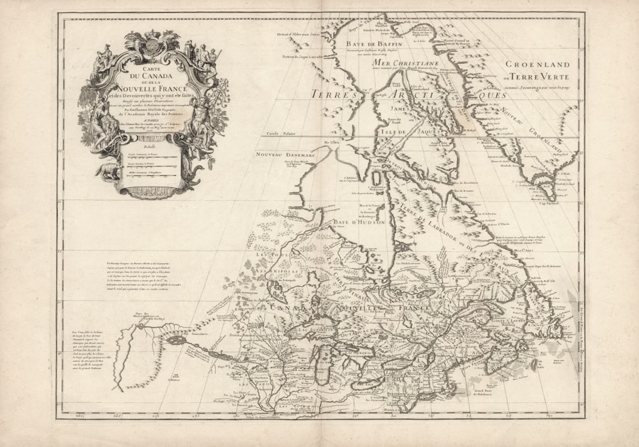
The Piri Reis Map, a remarkable artifact from the early 16th century, has captivated historians, cartographers, and enthusiasts alike. Created by the Ottoman admiral and cartographer Piri Reis in 1513, this map is notable not only for its artistic quality but also for its intriguing depictions of the world as it was known during that era. The map is particularly famous for its representation of the coastlines of South America and parts of Africa, as well as its controversial portrayal of Antarctica, which has sparked debates about the extent of geographical knowledge in the pre-modern world.
The Piri Reis Map serves as a window into the past, revealing insights into the navigational practices and cultural exchanges of the time. As one delves deeper into the Piri Reis Map, it becomes evident that it is more than just a navigational tool; it is a historical document that encapsulates the spirit of exploration during the Age of Discovery. The map’s intricate details and annotations provide a glimpse into the maritime routes and territorial claims of the early 16th century.
Furthermore, the map raises questions about the sources of information available to Piri Reis and the methods he employed in its creation. This article aims to explore the history, controversies, and significance of the Piri Reis Map, shedding light on its enduring legacy in the realms of cartography and exploration.
Key Takeaways
- The Piri Reis Map is a famous historical map that has sparked controversy and mystery due to its accuracy and the symbols and inscriptions it contains.
- The map’s origins and the truth behind its creation are still subjects of speculation and ongoing research, with various theories about its origins and significance.
- Despite the controversies, the Piri Reis Map has had a significant influence on cartography and exploration, shaping our understanding of historical geography.
- Modern-day relevance of the map lies in its ability to provide insights into the past and present, shedding light on historical events and geographical knowledge.
- Ongoing research and studies continue to unravel the mysteries of the Piri Reis Map, offering new perspectives on its accuracy and significance in understanding our world.
History and Background of the Piri Reis Map
The origins of the Piri Reis Map can be traced back to a time when European powers were fervently exploring new territories across the globe. Piri Reis, born in 1465 in what is now Turkey, was not only a skilled navigator but also a military leader who played a significant role in the Ottoman Empire’s naval endeavors. His map was created during a period marked by intense competition among European nations for dominance over trade routes and colonial territories.
The map itself is believed to have been drawn from various sources, including earlier maps and accounts from explorers who ventured into uncharted waters. The Piri Reis Map is particularly significant because it represents one of the earliest known depictions of the New World. It includes detailed illustrations of the coastlines of South America, particularly Brazil, as well as parts of North America.
The map also features annotations in Turkish, providing insights into the geographical knowledge of the time. Piri Reis’s work was not an isolated endeavor; it was part of a broader tradition of map-making that sought to document and understand the rapidly changing world. The map’s creation reflects a confluence of knowledge from different cultures, showcasing how information was shared and adapted across civilizations.
Controversies and Mysteries Surrounding the Piri Reis Map
The Piri Reis Map has long been shrouded in controversy and mystery, primarily due to its unexpected accuracy and the enigmatic symbols it contains.
Some researchers argue that this suggests advanced knowledge of the continent’s geography long before it was officially charted.
This claim has led to various theories about ancient civilizations possessing sophisticated navigational skills that have since been lost to history. Additionally, there are questions surrounding the sources that Piri Reis used to create his map. The map includes references to earlier cartographic works, some of which are believed to have been lost or destroyed over time.
This raises intriguing possibilities about how information was transmitted across cultures and how explorers like Piri Reis synthesized this knowledge into their own works. The controversies surrounding the map have fueled speculation about its origins and implications, making it a focal point for those interested in uncovering hidden truths about human exploration.
Decoding the Symbols and Inscriptions on the Piri Reis Map
| Decoding the Symbols and Inscriptions on the Piri Reis Map | |
|---|---|
| Map Creator | Piri Reis |
| Creation Date | 1513 |
| Map Type | World map |
| Features | Coastlines, islands, and geographical features |
| Controversy | Alleged depiction of Antarctica and advanced knowledge of geography |
The symbols and inscriptions on the Piri Reis Map are key to understanding its significance and purpose. The map features a variety of illustrations, including depictions of animals, ships, and even mythical creatures, which were common in cartography during that period. These symbols served not only as decorative elements but also as navigational aids that provided context for sailors venturing into unfamiliar waters.
The inscriptions, written in Ottoman Turkish, offer valuable insights into Piri Reis’s thought process and his understanding of geography. Decoding these symbols requires a careful examination of both their artistic representation and their practical implications for navigation. For instance, certain symbols may indicate specific landmarks or hazards that sailors needed to be aware of while traversing coastal waters.
Furthermore, some researchers have suggested that hidden meanings may lie within these symbols, hinting at deeper cultural or historical narratives that have yet to be fully understood. As scholars continue to analyze these elements, they contribute to a richer understanding of how maps functioned as tools for exploration and communication in the past.
Exploring the Accuracy of the Piri Reis Map
One of the most striking features of the Piri Reis Map is its remarkable accuracy for its time. When compared to modern maps, certain aspects of Piri Reis’s work align surprisingly well with contemporary geographical knowledge. For example, his depiction of South America’s coastline is notably precise, capturing key features such as rivers and bays that would later be confirmed by explorers in subsequent centuries.
This accuracy raises questions about how Piri Reis was able to achieve such detailed representations without access to modern navigational tools. The accuracy of the Piri Reis Map has led some scholars to propose that it was based on a compilation of various sources, including earlier maps created by explorers from different cultures. This notion suggests that there was a rich exchange of geographical knowledge occurring during this period, challenging traditional narratives about European superiority in exploration.
By examining the map’s accuracy, researchers can gain insights into the collaborative nature of cartography and how different civilizations contributed to a shared understanding of the world.
Theories and Speculations about the Origins of the Piri Reis Map
The origins of the Piri Reis Map have sparked numerous theories and speculations among historians and researchers. Some suggest that it was influenced by earlier maps created by explorers such as Christopher Columbus or Amerigo Vespucci, while others propose that it draws from ancient sources that have since been lost to history. The idea that Piri Reis may have had access to knowledge from civilizations such as the Phoenicians or even earlier cultures adds an intriguing layer to discussions about the map’s origins.
Another theory posits that the map reflects a synthesis of knowledge from various cultures encountered by Ottoman explorers during their maritime expeditions.
As researchers continue to investigate these theories, they contribute to a broader understanding of how maps serve as reflections of human experience and exploration throughout history.
Uncovering the Truth Behind the Piri Reis Map
Uncovering the truth behind the Piri Reis Map involves delving into both its historical context and its enduring mysteries. Scholars have employed various methodologies to analyze its content, including comparative studies with other historical maps and archaeological findings related to maritime exploration. By examining these connections, researchers aim to piece together a more comprehensive narrative about how Piri Reis created his map and what it reveals about his worldview.
Moreover, advancements in technology have allowed for new approaches to studying historical artifacts like the Piri Reis Map. Techniques such as digital imaging and geographic information systems (GIS) enable researchers to analyze its features with unprecedented precision. These modern tools provide fresh insights into how navigational practices evolved over time and how maps like those created by Piri Reis played a crucial role in shaping human understanding of geography.
The Piri Reis Map’s Influence on Cartography and Exploration
The influence of the Piri Reis Map on cartography and exploration cannot be overstated. As one of the earliest known maps depicting parts of the New World with such detail, it served as a reference point for subsequent explorers and cartographers seeking to navigate uncharted territories. Its unique blend of artistic representation and practical navigation made it an invaluable resource for those venturing into unfamiliar waters.
Furthermore, the Piri Reis Map exemplifies how maps functioned as cultural artifacts that reflected societal values and aspirations during a time of exploration. It highlights the importance placed on maritime navigation and territorial claims by various powers during the Age of Discovery. As such, it has left an indelible mark on both historical cartography and contemporary understandings of exploration.
Modern-Day Relevance and Significance of the Piri Reis Map
In today’s world, the relevance of the Piri Reis Map extends beyond its historical context; it continues to inspire curiosity about human exploration and our relationship with geography. The map serves as a reminder of humanity’s enduring quest for knowledge and understanding, prompting discussions about how we perceive our world today. Its intricate details invite modern audiences to reflect on how far navigational practices have come since its creation while also acknowledging the contributions made by diverse cultures throughout history.
Moreover, contemporary scholars often draw parallels between past explorations represented in maps like that of Piri Reis and current global challenges related to climate change, territorial disputes, and cultural preservation. By examining historical artifacts through a modern lens, researchers can foster greater awareness about our shared heritage and encourage dialogue about responsible stewardship of our planet.
Ongoing Research and Studies on the Piri Reis Map
Ongoing research into the Piri Reis Map continues to yield new insights into its significance within both historical and contemporary contexts. Scholars from various disciplines—ranging from history to geography—are actively engaged in studying its content, origins, and implications for understanding human exploration. Collaborative efforts among researchers worldwide have led to interdisciplinary approaches that enrich discussions surrounding this remarkable artifact.
Additionally, advancements in technology have opened new avenues for research on historical maps like that created by Piri Reis. Digital archives allow for greater accessibility to primary sources while enabling scholars to conduct comparative analyses with other cartographic works from different cultures. As research progresses, it promises to deepen our understanding not only of this specific map but also of broader themes related to navigation, cultural exchange, and human curiosity throughout history.
What the Piri Reis Map Reveals about the Past and Present
The Piri Reis Map stands as a testament to humanity’s enduring quest for knowledge about our world—a quest that transcends time and culture. Through its intricate details and historical significance, it reveals much about early navigational practices while also prompting questions about lost knowledge and cultural exchanges between civilizations. As scholars continue their investigations into this remarkable artifact, they uncover layers of meaning that resonate with contemporary discussions surrounding exploration, geography, and our place within an ever-evolving world.
Ultimately, what emerges from studying the Piri Reis Map is not just an appreciation for its artistic beauty or historical context but also an acknowledgment of our shared human experience—a journey marked by curiosity, discovery, and an unyielding desire to understand our surroundings better. In this way, the map serves as both a reflection on our past endeavors in exploration and an invitation for future generations to continue seeking knowledge about their world.
The Piri Reis map, a fascinating artifact from the early 16th century, continues to intrigue historians and cartographers with its detailed depiction of the known world at the time. For those interested in exploring more about ancient maps and their mysterious origins, a related article can be found on the Real Lore and Order website. This article delves into the broader context of historical cartography and the enigmatic stories behind some of the world’s most famous maps. To read more about these captivating tales, visit Real Lore and Order.
WATCH THIS 🧊The US Military Confirmed It: What’s REALLY Under the Antarctic Ice?
FAQs
What is the Piri Reis map?
The Piri Reis map is a world map created by Ottoman admiral and cartographer Piri Reis in 1513. It is notable for its depiction of the Americas and Antarctica, which were not officially discovered until several years later.
What makes the Piri Reis map controversial?
The controversial aspect of the Piri Reis map is its depiction of Antarctica, as it shows the continent’s coastline without ice. This has led to speculation and debate about how the map’s creator could have had knowledge of Antarctica’s geography before it was covered in ice.
What are some theories about the Piri Reis map’s accuracy?
Some theories suggest that the Piri Reis map’s accuracy is evidence of advanced ancient civilizations or extraterrestrial influence. However, mainstream scholars attribute the map’s accuracy to a combination of lucky guesswork, misinterpretation of existing geographical knowledge, and possibly some degree of distortion in the map’s depiction of Antarctica.
What do mainstream scholars say about the Piri Reis map?
Mainstream scholars generally view the Piri Reis map as an interesting historical artifact, but they do not consider it to be evidence of advanced ancient knowledge or extraterrestrial influence. They attribute its accuracy to a combination of factors, including the use of existing maps and navigational techniques of the time.
Is the Piri Reis map still studied today?
Yes, the Piri Reis map continues to be studied by historians, cartographers, and researchers interested in the history of cartography and the exploration of the Americas. It remains a subject of fascination and debate due to its unique depiction of Antarctica and the Americas.