Ptolemaic geography, rooted in the works of the ancient Greek scholar Claudius Ptolemy, represents a significant milestone in the evolution of cartographic science. Living in the second century CE, Ptolemy synthesized the geographical knowledge of his time, producing a comprehensive framework that would influence generations of scholars and mapmakers. His seminal work, “Geographia,” not only cataloged the known world but also introduced innovative concepts such as latitude and longitude, which provided a systematic approach to mapping the Earth.
This foundational text laid the groundwork for future explorations and cartographic endeavors, establishing a standard that would be referenced and revered throughout history. The significance of Ptolemaic geography extends beyond mere mapmaking; it encapsulates a worldview that sought to understand the relationship between humanity and the Earth. Ptolemy’s meticulous observations and calculations were groundbreaking, as they attempted to create an accurate representation of the known world.
His maps, while limited by the knowledge and technology of his time, offered a glimpse into the geographical understanding of ancient civilizations. As such, Ptolemaic geography serves as a crucial link between antiquity and the medieval period, influencing both Islamic and European cartography in profound ways.
Key Takeaways
- Ptolemy’s Geography laid the foundational framework for medieval cartography, influencing mapmaking across cultures.
- Islamic scholars played a crucial role in preserving and enhancing Ptolemaic geographic knowledge during the Middle Ages.
- European cartographers adapted Ptolemaic concepts, integrating them with new discoveries to improve map accuracy.
- Despite some inaccuracies, Ptolemaic Geography significantly impacted exploration by shaping medieval geographic understanding.
- The legacy of Ptolemy’s work persists in modern cartography, underscoring its enduring influence on geographic knowledge.
The Influence of Ptolemy’s Geography on Medieval Cartography
The impact of Ptolemy’s geography on medieval cartography cannot be overstated. During the Middle Ages, scholars in Europe and the Islamic world turned to Ptolemy’s works as authoritative sources of geographical knowledge.
Medieval cartographers adopted these principles, integrating them into their own maps while also adapting them to reflect contemporary understandings of geography. In Europe, the revival of interest in Ptolemy’s geography during the Renaissance marked a pivotal moment in cartographic history. The translation of “Geographia” into Latin made it accessible to a broader audience, igniting a renewed fascination with ancient knowledge.
This resurgence led to the production of numerous maps that emulated Ptolemaic principles, often blending them with medieval perspectives. As a result, Ptolemy’s influence can be seen in the way medieval maps depicted not only physical landscapes but also cultural and political boundaries, reflecting the complexities of the societies that created them.
The Transmission of Ptolemaic Maps to the Medieval World

The transmission of Ptolemaic maps to the medieval world was facilitated by various channels, including trade, scholarship, and conquest. As the Roman Empire expanded, so too did the dissemination of Ptolemy’s geographical ideas. After the fall of Rome, these concepts were preserved and transmitted through Byzantine scholars who continued to study and copy ancient texts.
The preservation of Ptolemy’s work in monasteries and libraries ensured that his geographical insights would not be lost to time. In addition to Byzantine scholars, Islamic scholars played a crucial role in transmitting Ptolemaic geography to the medieval world. During the Islamic Golden Age, which spanned from the 8th to the 14th centuries, scholars such as Al-Khwarizmi and Al-Idrisi built upon Ptolemy’s foundations, translating his works into Arabic and expanding upon them with their own observations.
This cross-cultural exchange enriched both Islamic and European cartography, as ideas flowed between civilizations. The maps produced during this period often incorporated Ptolemaic elements while also reflecting the unique geographical knowledge acquired through exploration and trade.
Ptolemaic Geography in Islamic Cartography
Islamic cartography during the medieval period was significantly influenced by Ptolemaic geography, which provided a framework for understanding the world that was both systematic and comprehensive. Scholars in the Islamic world embraced Ptolemy’s concepts of latitude and longitude, adapting them to their own geographical contexts. This adaptation was not merely a replication; rather, it involved a synthesis of Ptolemaic ideas with local knowledge and observations from explorers who traveled across vast regions.
One notable figure in Islamic cartography was Al-Idrisi, whose work “Tabula Rogeriana” synthesized Ptolemaic geography with contemporary knowledge from travelers and merchants. Al-Idrisi’s maps were characterized by their detail and accuracy, reflecting a deep understanding of both physical geography and cultural landscapes.
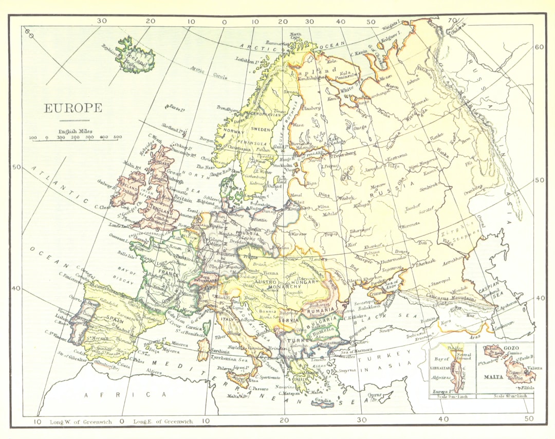
Ptolemaic Geography in European Cartography
| Metric | Description | Value/Example |
|---|---|---|
| Time Period | Era when Ptolemaic geography influenced medieval maps | 2nd century AD to 15th century |
| Primary Source | Key text used for geographic knowledge | Claudius Ptolemy’s “Geographia” |
| Map Projection | Projection method used in Ptolemaic maps | Conic and Stereographic projections |
| Number of Coordinates | Approximate number of place coordinates listed by Ptolemy | 8,000+ locations |
| Medieval Map Types | Common types of maps influenced by Ptolemaic geography | Tabulae, Mappa Mundi, Portolan charts |
| Accuracy | Relative accuracy of medieval Ptolemaic maps compared to modern maps | Approx. 70-80% accuracy in Mediterranean region |
| Geographic Scope | Regions covered in Ptolemaic medieval maps | Europe, North Africa, parts of Asia |
| Influence on Exploration | Impact on later explorers and mapmakers | Basis for Age of Discovery navigation |
In Europe, the influence of Ptolemaic geography became increasingly pronounced during the Renaissance, a period marked by a revival of classical learning and exploration. The reintroduction of Ptolemy’s works into European scholarship sparked a renewed interest in accurate mapping techniques. Cartographers began to adopt his methods for representing geographical features, leading to more precise depictions of landmasses and coastlines.
The emergence of printed maps in the 15th century further facilitated the spread of Ptolemaic ideas across Europe. With advancements in printing technology, maps could be produced more efficiently and disseminated widely. This accessibility allowed for greater collaboration among scholars and mapmakers, who could share insights and refine their techniques based on Ptolemaic principles.
As a result, European cartography evolved rapidly during this period, culminating in maps that not only reflected geographical accuracy but also embodied artistic expression.
The Accuracy and Inaccuracy of Ptolemaic Geography in Medieval Maps
While Ptolemaic geography laid a solid foundation for cartographic practices, it was not without its inaccuracies. The limitations of ancient knowledge and technology meant that many aspects of Ptolemy’s maps were flawed or outdated by medieval standards. For instance, his depiction of certain regions was often based on secondhand accounts or speculative information rather than direct observation.
Consequently, medieval maps that relied heavily on Ptolemy’s work sometimes perpetuated these inaccuracies. Despite these shortcomings, medieval cartographers often sought to reconcile Ptolemaic geography with their own observations and experiences. They would incorporate new information gleaned from explorers or traders into their maps while still adhering to Ptolemaic principles.
This blending of old and new knowledge resulted in maps that were both innovative and reflective of contemporary understanding. While some inaccuracies persisted, these efforts marked a significant step toward more accurate representations of the world.
The Impact of Ptolemaic Geography on Exploration and Discovery
Ptolemaic geography had a profound impact on exploration and discovery during the medieval period. The systematic approach to mapping introduced by Ptolemy inspired explorers to venture beyond known territories in search of new lands and resources. The desire to create more accurate maps fueled expeditions that expanded geographical knowledge significantly.
As explorers set out on their journeys armed with Ptolemaic principles, they encountered new cultures and landscapes that challenged existing notions of geography. The information gathered during these explorations often found its way back into cartographic practices, leading to an iterative process where maps were continuously updated based on firsthand accounts. This dynamic relationship between exploration and mapping not only enriched geographic knowledge but also fostered a spirit of curiosity that characterized the Age of Discovery.
Ptolemaic Geography and the Development of Geographic Knowledge in the Middle Ages
The development of geographic knowledge during the Middle Ages was intricately linked to Ptolemaic geography. As scholars engaged with Ptolemy’s works, they began to question existing assumptions about the world and sought to expand their understanding through observation and inquiry. This intellectual curiosity laid the groundwork for advancements in various fields, including astronomy, navigation, and cartography.
Medieval scholars built upon Ptolemy’s ideas by incorporating new discoveries from travelers and explorers into their geographic frameworks. This synthesis of ancient knowledge with contemporary observations led to a more nuanced understanding of geography that transcended mere mapmaking. Scholars began to explore concepts such as climate zones, trade routes, and cultural interactions, recognizing that geography was not just about physical landscapes but also about human experiences within those spaces.
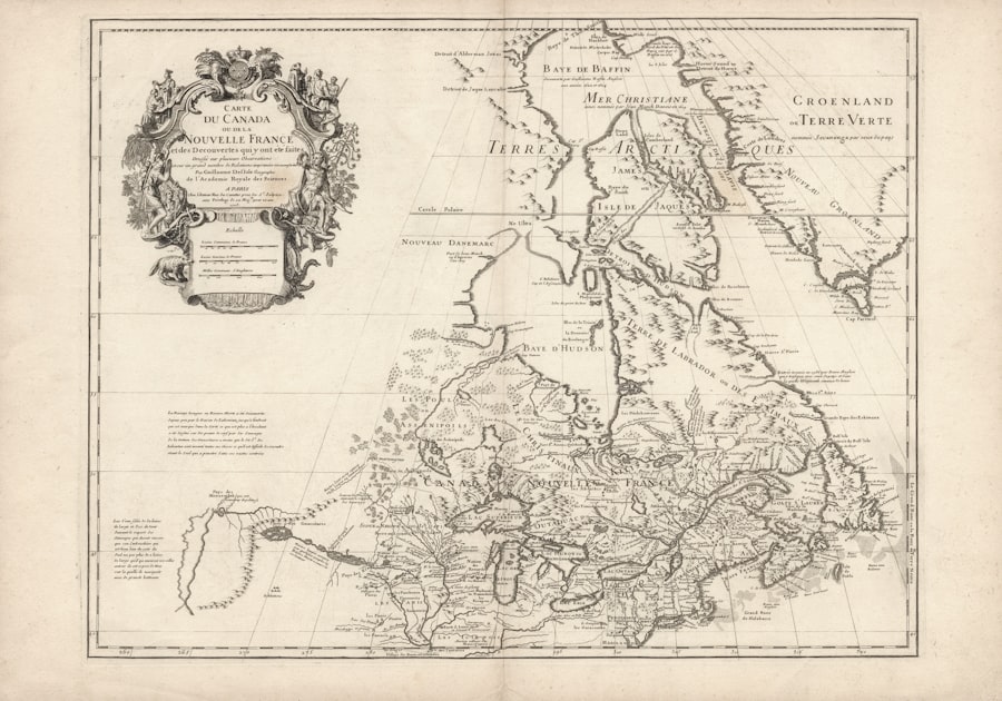
Ptolemaic Geography in Manuscript and Printed Maps
The legacy of Ptolemaic geography is evident in both manuscript and printed maps produced during the medieval period. Manuscript maps often reflected a blend of artistic expression and scientific inquiry, showcasing intricate designs that captured the imagination while adhering to Ptolemaic principles. These hand-drawn maps served as valuable tools for navigation and education, allowing scholars to convey complex geographical information in visually engaging ways.
With the advent of printing technology in the 15th century, maps became more widely accessible than ever before. Printed maps drew heavily from Ptolemaic geography while also incorporating contemporary knowledge gained through exploration. The ability to reproduce maps efficiently allowed for greater dissemination of geographic information across Europe, fostering collaboration among scholars and mapmakers who sought to refine their understanding of the world.
The Legacy of Ptolemaic Geography in Modern Cartography
The legacy of Ptolemaic geography continues to resonate in modern cartography. Many foundational concepts introduced by Ptolemy—such as latitude and longitude—remain integral to contemporary mapping practices. The systematic approach to representing geographical features laid out by Ptolemy has evolved but still serves as a cornerstone for modern geographic information systems (GIS) and digital mapping technologies.
Moreover, the spirit of inquiry that characterized Ptolemy’s work endures in today’s exploration of uncharted territories and advancements in geographic research. As modern cartographers strive for greater accuracy and representation in their maps, they often look back at historical figures like Ptolemy for inspiration. His contributions have shaped not only how maps are created but also how societies understand their place within the world.
The Enduring Influence of Ptolemaic Geography on Maps and Geographic Understanding
In conclusion, the enduring influence of Ptolemaic geography on maps and geographic understanding is undeniable. From its inception in antiquity through its transmission to medieval scholars across cultures, Ptolemy’s work has left an indelible mark on cartography that continues to shape our perception of space today. The synthesis of ancient knowledge with contemporary observations fostered an environment ripe for exploration and discovery during the Middle Ages.
As modern cartographers build upon this rich legacy, they acknowledge the foundational role played by figures like Claudius Ptolemy in shaping our understanding of geography. His innovative concepts have transcended time, guiding generations toward more accurate representations of our world while inspiring curiosity about what lies beyond known horizons. Ultimately, Ptolemaic geography serves as a testament to humanity’s quest for knowledge—a quest that remains as relevant today as it was over two millennia ago.
Ptolemaic geography had a significant influence on medieval maps, shaping the way the world was understood during that era. For a deeper exploration of how these ancient concepts were integrated into medieval cartography, you can read the article on Real Lore and Order, which discusses the evolution of map-making techniques and the impact of Ptolemy’s work on later geographers.
WATCH THIS! 🗺️ The Map That Proves Humans Explored Earth 5,000 Years Too Early
FAQs
What is Ptolemaic geography?
Ptolemaic geography refers to the geographical knowledge and mapping techniques based on the work of Claudius Ptolemy, a Greco-Roman mathematician, astronomer, and geographer from the 2nd century AD. His work, particularly the “Geographia,” compiled and systematized the geographical knowledge of the Roman Empire and introduced the use of latitude and longitude for mapping.
How did Ptolemaic geography influence medieval maps?
Ptolemaic geography significantly influenced medieval maps by providing a framework for representing the world using a coordinate system. Medieval cartographers used Ptolemy’s methods to create more accurate and systematic maps, often incorporating his concepts of latitude and longitude, which helped improve navigation and understanding of the world during the Middle Ages.
What are the key features of medieval maps based on Ptolemaic geography?
Medieval maps based on Ptolemaic geography typically feature a grid of latitude and longitude lines, attempts at proportional scaling, and a focus on the known world as described by Ptolemy. These maps often combined classical knowledge with contemporary medieval information, sometimes including mythical or religious elements alongside geographical data.
When were Ptolemy’s geographical works rediscovered in medieval Europe?
Ptolemy’s geographical works were rediscovered in medieval Europe primarily during the 13th century, especially after the translation of his “Geographia” from Greek and Arabic into Latin. This rediscovery played a crucial role in the development of cartography during the late Middle Ages and the Renaissance.
Did medieval maps based on Ptolemaic geography include the entire world?
No, medieval maps based on Ptolemaic geography did not include the entire world as we know it today. They were limited to the known world of the time, primarily Europe, parts of Asia, and North Africa. The Americas and other regions were unknown to Ptolemy and medieval cartographers.
How accurate were medieval maps influenced by Ptolemaic geography?
While medieval maps influenced by Ptolemaic geography were more systematic than earlier maps, their accuracy was limited by the knowledge and technology of the time. Distortions and inaccuracies were common due to incomplete information, but the use of latitude and longitude represented a significant advancement in cartographic science.
What role did Ptolemaic geography play in the Age of Exploration?
Ptolemaic geography provided a foundational framework for navigation and mapmaking during the Age of Exploration. Explorers and cartographers used Ptolemy’s coordinate system and geographical concepts to chart new territories and improve sea navigation, which contributed to the expansion of European exploration in the 15th and 16th centuries.