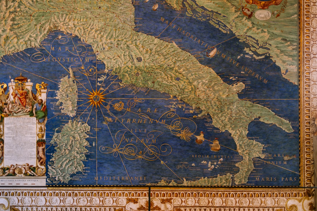
The Piri Reis Map, created in 1513, stands as one of the most intriguing artifacts of the Age of Exploration. This ancient map, drawn by the Ottoman admiral and cartographer Piri Reis, is notable not only for its artistic detail but also for its controversial depictions of the world as it was known during the early 16th century. The map is particularly famous for its representation of parts of South America and the western coast of Africa, but what truly captivates scholars and enthusiasts alike is its alleged depiction of Antarctica, a landmass that was not officially discovered until centuries later.
The map’s existence raises questions about the knowledge and navigational capabilities of ancient civilizations, suggesting that they may have possessed information that has since been lost to history. The discovery of the Piri Reis Map occurred in 1929 when it was found in the Topkapi Palace in Istanbul, Turkey. This revelation sparked a wave of interest and speculation regarding its origins and the accuracy of its content.
The map is drawn on a piece of worn parchment and features a blend of various sources, including ancient Greek and Roman maps, as well as information from explorers who had ventured into uncharted territories. The combination of these elements creates a tapestry of geographical knowledge that challenges conventional understandings of cartography during that era.
Key Takeaways
- The Piri Reis Map is a mysterious discovery that has puzzled scholars and scientists for centuries.
- The enigmatic origins of the map have sparked debates about its accuracy and the technology available at the time of its creation.
- Charles Hapgood, a controversial figure, proposed the theory of Earth Crust Displacement to explain the anomalies in the Piri Reis Map.
- Despite the theory’s popularity, modern technology has debunked the map’s supposed evidence of Earth Crust Displacement.
- The debate among scholars and scientists continues as they explore the cultural and historical significance of the Piri Reis Map and its influence on cartography.
The Enigmatic Origins of the Piri Reis Map
The origins of the Piri Reis Map are shrouded in mystery, with many questions surrounding how such an intricate representation of the world was created in the early 16th century. Piri Reis himself was a seasoned navigator and cartographer, having served in the Ottoman navy. His work reflects not only his personal experiences but also the collective knowledge of various cultures that had come into contact with one another through trade and exploration.
The map is believed to have been compiled from over twenty different sources, including maps from ancient civilizations such as the Greeks and Egyptians, as well as more contemporary European explorations. One particularly fascinating aspect of the Piri Reis Map is its use of projection techniques that were advanced for its time. The map employs a unique method of depicting landmasses that suggests a sophisticated understanding of geography and cartography.
This raises questions about how Piri Reis and his contemporaries acquired such knowledge. Some theorists propose that ancient civilizations may have possessed advanced navigational tools or even lost technologies that allowed them to chart the world with remarkable accuracy. The blending of various cultural influences in the map’s creation further complicates its origins, leading to speculation about the interconnectedness of ancient societies and their shared knowledge.
Charles Hapgood: The Controversial Figure Behind the Theory
Charles Hapgood emerged as a pivotal figure in discussions surrounding the Piri Reis Map, particularly through his controversial theories regarding ancient civilizations and their capabilities. An American historian and author, Hapgood gained notoriety for his book “Maps of the Ancient Sea Kings,” published in 1966, where he posited that the Piri Reis Map was evidence of advanced prehistoric civilizations that had existed long before recorded history. His theories suggested that these civilizations possessed knowledge of geography that was far beyond what was previously believed possible.
Hapgood’s ideas were met with skepticism by many in the academic community, yet they resonated with those intrigued by the possibility of lost civilizations. He argued that the map’s accuracy in depicting coastlines and landmasses could not be explained solely by the navigational skills of Piri Reis or his contemporaries. Instead, he proposed that this knowledge had been passed down from earlier cultures that had achieved a level of sophistication in navigation and cartography that had since been forgotten.
This assertion opened up a Pandora’s box of debates regarding human history, exploration, and the potential for ancient technologies that have yet to be fully understood.
The Theory of Earth Crust Displacement
| Metrics | Values |
|---|---|
| Displacement Rate | 2-20 meters per year |
| Duration of Displacement | Thousands of years |
| Impact on Climate | Shift in climate patterns |
| Geological Evidence | Striated rock formations |
One of Hapgood’s most controversial theories was his concept of Earth crust displacement, which he proposed as an explanation for significant shifts in climate and geography throughout history. According to Hapgood, the Earth’s crust could shift over geological time scales due to various factors, leading to dramatic changes in climate and land formations. He suggested that such displacements could account for the existence of ancient maps like that of Piri Reis, which depicted landmasses that were not accessible or known to contemporary explorers.
Hapgood’s theory posited that these crustal shifts could have caused entire civilizations to be lost to time, their knowledge and achievements buried beneath layers of earth or submerged beneath rising seas. This idea resonated with those who sought to explain why certain ancient cultures seemed to possess advanced knowledge without leaving behind substantial evidence of their existence. While his theory garnered attention, it also faced significant criticism from geologists and scientists who argued against the feasibility of such rapid crustal movements occurring within human history.
Debunking the Piri Reis Map and Earth Crust Displacement Theory
Despite its allure, both the Piri Reis Map and Hapgood’s Earth crust displacement theory have faced considerable scrutiny from scholars and scientists alike. Critics argue that while the map does contain remarkable details, it can be explained through more conventional means rather than suggesting lost civilizations or advanced technologies. Many believe that Piri Reis utilized existing maps and navigational knowledge available during his time, synthesizing this information into his own work without needing to invoke extraordinary explanations.
Furthermore, geological evidence does not support Hapgood’s theory of rapid crustal displacement. Geologists emphasize that while tectonic shifts do occur over millions of years, they do not happen at a pace that would account for sudden changes in geography as suggested by Hapgood. The scientific community largely views his theories as speculative at best, lacking empirical support necessary for acceptance within established geological frameworks.
This skepticism has led to ongoing debates about the validity of both Hapgood’s ideas and the implications they hold for understanding human history.
The Debate Among Scholars and Scientists
The discourse surrounding the Piri Reis Map and Hapgood’s theories has sparked a vibrant debate among scholars and scientists across various disciplines. While some historians embrace Hapgood’s ideas as a means to challenge conventional narratives about human exploration and knowledge, others remain firmly rooted in established historical frameworks. This division highlights a broader tension between traditional scholarship and more speculative approaches to understanding ancient civilizations.
Proponents of Hapgood’s theories often cite instances where ancient cultures demonstrated remarkable achievements in navigation and cartography, suggesting that these accomplishments warrant further investigation into lost knowledge or technologies. Conversely, skeptics argue that attributing advanced capabilities to ancient societies without substantial evidence undermines rigorous historical research. This ongoing debate reflects not only differing perspectives on the Piri Reis Map but also broader questions about how history is constructed and understood.
Modern Technology and the Piri Reis Map
In recent years, advancements in technology have provided new avenues for exploring the mysteries surrounding the Piri Reis Map. Geographic Information Systems (GIS) and satellite imaging have allowed researchers to analyze the map’s details with unprecedented precision. These tools enable scholars to compare the map’s depictions with modern geographical data, potentially shedding light on its accuracy and origins.
Moreover, modern archaeological techniques have uncovered new insights into ancient navigation practices, suggesting that early explorers may have employed sophisticated methods for charting their journeys. As technology continues to evolve, it offers fresh perspectives on historical artifacts like the Piri Reis Map, allowing researchers to reevaluate long-held assumptions about ancient knowledge and capabilities. This intersection of technology and history holds promise for uncovering further mysteries related to human exploration.
The Legacy of Charles Hapgood and the Piri Reis Map
Charles Hapgood’s legacy remains intertwined with discussions about the Piri Reis Map, as his theories continue to inspire both admiration and skepticism within academic circles. While many scholars dismiss his ideas as fringe theories lacking empirical support, others recognize his contributions to expanding discussions about ancient civilizations and their potential achievements. His work has encouraged subsequent generations to question established narratives about history and explore alternative explanations for humanity’s past.
The Piri Reis Map itself endures as a symbol of curiosity and intrigue, captivating those who seek to understand its origins and implications. It serves as a reminder that history is often more complex than it appears on the surface, inviting ongoing exploration into humanity’s collective journey through time. As new discoveries emerge and technology advances, both Hapgood’s legacy and the mysteries surrounding the Piri Reis Map will likely continue to inspire inquiry into ancient knowledge.
The Cultural and Historical Significance of the Piri Reis Map
The cultural significance of the Piri Reis Map extends beyond its geographical depictions; it embodies a confluence of knowledge from diverse civilizations throughout history. The map reflects not only Ottoman cartographic traditions but also incorporates insights from European explorers and ancient cultures such as those from Greece and Egypt. This blending highlights how interconnected human societies have always been, sharing knowledge across borders long before globalization became a modern phenomenon.
Historically, the map serves as a testament to humanity’s enduring quest for exploration and understanding of the world around them. It encapsulates an era when navigation was fraught with uncertainty yet driven by an insatiable curiosity about distant lands. The Piri Reis Map stands as a reminder that even in an age dominated by technological advancements, there remains much to learn from our ancestors’ attempts to chart their world—a pursuit that continues to resonate with contemporary explorers today.
The Piri Reis Map and Its Influence on Cartography
The influence of the Piri Reis Map on cartography cannot be overstated; it represents a significant milestone in the evolution of map-making practices. Its intricate design and attention to detail set a precedent for future cartographers seeking to depict geographical realities accurately while incorporating artistic elements. The map’s unique projection techniques also contributed to discussions about how best to represent three-dimensional landscapes on two-dimensional surfaces—a challenge that continues to engage cartographers today.
Moreover, the Piri Reis Map has inspired subsequent generations to explore alternative approaches to mapping based on historical sources rather than solely relying on contemporary data. Its existence encourages scholars to investigate how ancient cultures approached navigation and representation, fostering a deeper appreciation for diverse cartographic traditions worldwide. As modern technology continues to reshape cartography, the legacy of maps like that of Piri Reis serves as a foundation upon which new innovations can build.
The Continued Quest for Uncovering Ancient Mysteries
The allure of uncovering ancient mysteries remains strong in contemporary society, with artifacts like the Piri Reis Map serving as focal points for exploration and inquiry. As researchers delve into historical records, archaeological findings, and technological advancements, they continue to seek answers about humanity’s past—questions that often lead back to artifacts steeped in intrigue. The quest for understanding ancient civilizations is not merely an academic pursuit; it resonates with humanity’s innate desire to connect with its roots and comprehend its place within history.
As new discoveries emerge—whether through archaeological digs or advancements in technology—the mysteries surrounding artifacts like the Piri Reis Map will likely continue to captivate minds across generations. In this ongoing journey toward enlightenment lies an opportunity for deeper connections between past and present—a reminder that history is not just a record but an ever-evolving narrative waiting to be explored.
The Piri Reis map, a world map compiled in 1513 by the Ottoman admiral and cartographer Piri Reis, has long intrigued historians and cartography enthusiasts due to its detailed depiction of the Atlantic coastlines. Charles Hapgood, a notable figure in the study of ancient maps, proposed that the Piri Reis map might be evidence of advanced ancient civilizations with knowledge of the world far beyond what was previously believed. For those interested in exploring more about the mysteries surrounding ancient maps and their implications, a related article can be found on Real Lore and Order’s website. You can read more about these fascinating topics by visiting this article.
WATCH THIS 🧊The US Military Confirmed It: What’s REALLY Under the Antarctic Ice?
FAQs
What is the Piri Reis map?
The Piri Reis map is a world map created by Ottoman admiral and cartographer Piri Reis in 1513. It is notable for its depiction of the coastlines of Europe, Africa, and the Americas.
Who is Charles Hapgood?
Charles Hapgood was an American college professor and author known for his theories about ancient maps and the possibility of advanced ancient civilizations.
What is the connection between the Piri Reis map and Charles Hapgood?
Charles Hapgood popularized the Piri Reis map in his book “Maps of the Ancient Sea Kings” published in 1966. He suggested that the map’s accuracy in depicting the coastline of Antarctica indicated the existence of an advanced ancient civilization with advanced navigational capabilities.
What is the controversy surrounding the Piri Reis map and Charles Hapgood’s theories?
Hapgood’s theories about the Piri Reis map and advanced ancient civilizations have been met with skepticism and criticism from mainstream historians and archaeologists. The accuracy of the map’s depiction of Antarctica has been called into question, and there is no conclusive evidence to support the existence of the advanced ancient civilization proposed by Hapgood.