
The silent earthen monuments of Cahokia, located near modern-day Collinsville, Illinois, comprise the largest pre-Columbian settlement north of Mexico. For centuries, these mounds stood as enigmatic testament to a sophisticated civilization, their purpose and genesis largely unknown to European settlers until systematic archaeological investigation began. Uncovering the urban planning secrets of Cahokia offers a profound insight into the capabilities of indigenous societies in North America, challenging simplistic narratives of their organizational structures.
The Rise of a Mississippian Metropolis
Cahokia’s ascendancy began around 1050 CE, transitioning from scattered villages into a densely populated urban center in a relatively short period known as the Mississippian Emergent period. This rapid development, often termed the “Big Bang” of Cahokia, suggests a concerted effort and a sophisticated understanding of resource management and social organization. The city flourished for approximately 300 years, reaching its zenith in the 12th century with an estimated population of 10,000 to 20,000 within its core, and potentially tens of thousands more in surrounding settlements connected to its sphere of influence.
Environmental Context and Resource Utilization
Cahokia was strategically situated within the rich floodplains of the Mississippi River, a fertile crescent that provided abundant agricultural resources, particularly maize. The river itself served as a vital transportation artery, connecting Cahokia to a vast network of trade routes extending across much of what is now the southeastern and central United States. This geographical advantage was not merely coincidental but a foundational element in the city’s growth. The inhabitants harnessed the annual flooding to replenish soil nutrients, creating an agricultural engine that supported its burgeoning population.
Social and Political Organization
The sheer scale of Cahokia demanded a complex social and political hierarchy. Evidence suggests a stratified society, with a ruling elite likely residing in premium locations, such as the summit of Monks Mound. This elite likely directed the labor of thousands of individuals in monumental construction projects and orchestrated the city’s economic and social functions. The organization of such a large workforce for earth-moving endeavors speaks to a powerful centralized authority capable of motivating and managing a diverse populace.
Monumental Architecture and Urban Layout
The most striking feature of Cahokia is its collection of earthen mounds, numbering over 120 at its peak, although many have been destroyed by agricultural and urban expansion. These mounds were not natural formations but engineered structures, serving a variety of purposes from burial sites to platforms for elite residences and ceremonial buildings. Their careful placement and alignment reveal a deliberate and sophisticated urban plan.
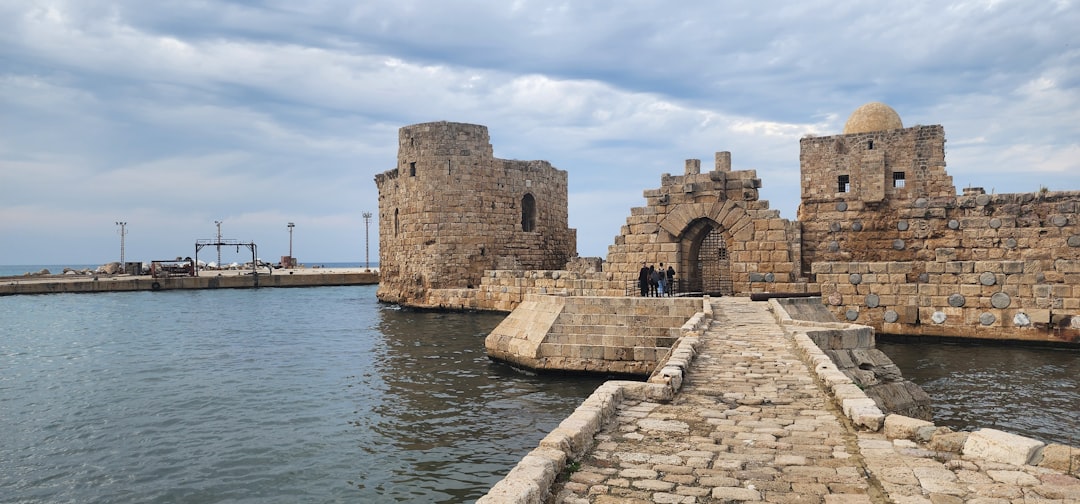
Monks Mound: The Heart of the City
Monks Mound, the largest prehistoric earthen structure in the Americas, stands as the central pillar of Cahokia’s urban design. Rising approximately 100 feet and covering nearly 14 acres at its base, it is a magnificent feat of engineering. Its construction, executed in multiple phases over centuries, involved moving an estimated 22 million cubic feet of earth by hand in baskets. The mound’s flat summit likely supported a massive building, possibly a temple or the residence of the paramount chief, offering a commanding view of the entire city. Its orientation and position suggest it was the spiritual and political nexus around which all other urban elements revolved.
Plaza Systems and Community Spaces
Surrounding Monks Mound were vast plazas, meticulously leveled and maintained, which served as public gathering spaces. The Grand Plaza, situated directly south of Monks Mound, covered an area of approximately 50 acres and was a focal point for communal activities, ceremonies, and possibly markets. The deliberate creation of such large, open spaces, free from residential encroachment, indicates an understanding of the need for public forums in a dense urban setting. These plazas were not merely empty spaces but vital arteries distributing the flow of people and energies throughout the city.
Residential Districts and Neighborhoods
Beyond the plazas, Cahokia extended into dense residential areas. Archaeological excavations have revealed evidence of thousands of pole-and-thatch houses, often arranged in rows or clusters. These residential zones were not chaotic sprawl but appear to have followed a discernible pattern, often oriented along cardinal directions. The presence of smaller mounds within these residential areas suggests a tiered hierarchy, with some neighborhoods possibly having their own local leadership or ceremonial centers. The careful arrangement of dwellings, even in dense concentrations, speaks to an underlying order and perhaps a system of land allocation.
Engineering Feats and Astronomical Alignments
The builders of Cahokia possessed remarkable engineering skills, extending beyond the sheer volume of earth moved. Their understanding of geometry, surveying, and possibly astronomy is evident in the precise alignments and construction techniques employed.
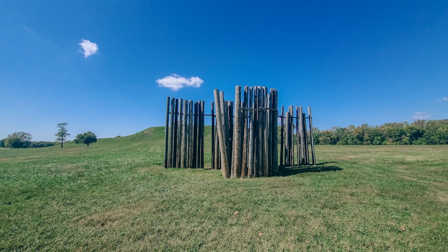
Woodhenges: Calendrical Observatories
Perhaps the most compelling evidence of sophisticated engineering and astronomical knowledge are the “Woodhenges” – large circular timber alignments. At least five such structures have been identified at Cahokia, each consisting of upright red cedar posts. The most extensively reconstructed, Woodhenge 72, comprised 48 posts arranged in a 410-foot diameter circle. These structures were meticulously aligned to mark significant celestial events, particularly the solstices and equinoxes. This suggests not only a deep understanding of astronomical cycles but also the ability to accurately survey and erect large-scale structures for precise calendrical purposes. The Woodhenges acted as ancient clocks and calendars, regulating agricultural cycles, ceremonial events, and perhaps even urban expansion.
Water Management and Drainage Systems
While not as extensively documented as their mound building, evidence suggests Cahokians also engaged in forms of water management. The city’s location on a flood plain presented both opportunities and challenges. While the floods deposited fertile silt, excessive inundation could be catastrophic. Archaeological findings indicate the presence of ditches and levees, alongside the natural bayous, that may have been used to manage water flow, drain areas, or even create fish ponds. This sophisticated interaction with their environment demonstrates a practical application of engineering principles to sustain their urban existence.
Causeway and Road Networks
Although many ancient roads vanish over time, archaeological investigations have uncovered evidence of elevated causeways and pathways connecting key areas of Cahokia. These pathways were not just convenient routes but integral components of the urban fabric, designed to facilitate movement, especially during periodic flooding. They also served to visually connect important civic and ceremonial centers, drawing the city together as a cohesive whole. The meticulous planning involved in creating an efficient network of transportation within such a large settlement highlights their forethought in urban design.
Decline and Legacy of a Lost City
Around 1200 CE, Cahokia began a period of decline, leading to its eventual abandonment by the mid-14th century. The reasons for this decline are complex and likely multifactorial, including environmental degradation, internal social unrest, disease, or external pressures. However, the urban planning principles and engineering prowess demonstrated by its builders left an indelible mark on the landscape and the archaeological record.
Environmental Factors and Resource Depletion
The sustained deforestation required for construction materials and fuel, coupled with intensive agriculture, likely placed immense strain on the local environment. Erosion and soil depletion could have reduced agricultural yields, challenging the city’s ability to feed its large population. While not the sole cause, environmental pressures undoubtedly played a role in the city’s decline. The metaphor of a complex ecosystem, delicately balanced, comes to mind – overexploitation, even with sophisticated planning, can lead to its eventual collapse.
Social and Political Instability
The immense social stratification necessary to build and maintain Cahokia may have also contained the seeds of its undoing. Internal conflicts, power struggles among the elite, or rebellions from the common populace could have destabilized the political structure. Changes in religious beliefs or the emergence of new cultural practices might also have contributed to a shift in population dynamics. The very features that allowed Cahokia to flourish might have also made it fragile to internal pressures.
Enduring Influence on Subsequent Cultures
Despite its abandonment, Cahokia’s influence resonated throughout the Mississippian world. Its architectural styles, ceramic traditions, and urban planning concepts were adopted and adapted by other Mississippian cultures across the southeastern United States. The city functioned as a crucible of innovation, disseminating its cultural and technological achievements far beyond its immediate boundaries. Thus, while the actual city became deserted, its legacy continued to shape the indigenous societies that followed. The ruins of Cahokia therefore serve not as a testament to failure, but as a monument to the extraordinary ingenuity and organizational capacity of its creators. Its unyielding silence now speaks volumes about the early urban aspirations of North America.
STOP: Why They Erased 50 Impossible Inventions From Your Textbooks
FAQs
What are the Cahokia Mounds?
The Cahokia Mounds are a prehistoric Native American city located near present-day Collinsville, Illinois. It was the largest urban center of the Mississippian culture, flourishing from approximately 1050 to 1350 CE.
Why is Cahokia significant in terms of urban planning?
Cahokia is significant because it demonstrates advanced urban planning techniques for its time, including a well-organized layout with large earthen mounds, plazas, residential areas, and a complex road system, reflecting sophisticated social and political organization.
What are some key features of Cahokia’s urban design?
Key features include the massive Monks Mound, a central plaza, a network of wooden palisades for protection, and an extensive system of elevated causeways and roads connecting different parts of the city and surrounding communities.
How did Cahokia’s planners manage resources and sustainability?
Cahokia’s planners utilized the surrounding environment efficiently by managing agricultural fields, water sources, and trade routes. They also implemented flood control measures and maintained the fertility of the land to support a large population.
What mysteries or secrets remain about Cahokia’s urban planning?
Despite extensive research, questions remain about the exact social hierarchy, the full extent of the city’s population, the reasons for its decline, and the specific methods used in constructing and maintaining the mounds and infrastructure.