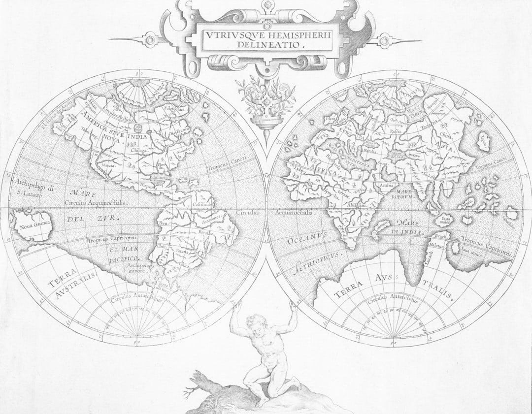
The Piri Reis Map, created in 1513 by the Ottoman admiral and cartographer Piri Reis, stands as a remarkable artifact of early cartography. This map is not merely a representation of geographical knowledge from the early 16th century; it is a window into the complexities of navigation, exploration, and the cultural exchanges of its time. The map is particularly notable for its depiction of parts of Europe, North Africa, and the coastlines of South America, showcasing a level of detail that was unprecedented for its era.
Crafted on a piece of worn parchment, the map is adorned with intricate illustrations and annotations that reflect the maritime knowledge and artistic sensibilities of the time. What makes the Piri Reis Map even more intriguing is its survival through centuries of history, including wars and natural disasters. It was rediscovered in 1929 in the Topkapi Palace in Istanbul, sparking interest among historians, geographers, and enthusiasts alike.
The map not only serves as a testament to Piri Reis’s skills as a cartographer but also raises questions about the sources of his information and the extent of knowledge about the world during the Age of Discovery. As scholars delve deeper into its origins and implications, the Piri Reis Map continues to captivate those who seek to understand the past.
Key Takeaways
- The Piri Reis Map is a famous world map created by Ottoman admiral Piri Reis in 1513.
- The mystery surrounding the map lies in its accurate depiction of Antarctica, a continent not officially discovered until 1820.
- Some believe the map points to a lost civilization with advanced knowledge of cartography and navigation.
- The controversy surrounding the map includes debates about its authenticity and the source of its information.
- Theories and speculations about the map range from extraterrestrial influence to ancient seafaring civilizations.
The Mystery of the Piri Reis Map
The allure of the Piri Reis Map lies in its enigmatic qualities. Despite being over 500 years old, it contains features that have puzzled historians and cartographers alike. One of the most striking aspects is its depiction of Antarctica, a continent that was not officially discovered until the early 19th century.
The map includes what appears to be a detailed representation of the continent’s coastline, leading some to speculate about ancient civilizations possessing advanced geographical knowledge long before modern exploration. Moreover, the map’s accuracy in portraying certain coastlines has led to debates about how Piri Reis acquired his information. Some believe he relied on earlier maps and navigational charts, possibly even those from lost civilizations or ancient mariners.
This raises questions about the transmission of knowledge across cultures and time periods. The mystery surrounding the Piri Reis Map is not just about its content; it also encompasses the broader implications of how humanity has understood and represented the world throughout history.
Uncovering the Lost Civilization

The Piri Reis Map has sparked theories regarding lost civilizations that may have existed long before recorded history. Some researchers propose that the map’s detailed depictions could be evidence of advanced societies that possessed sophisticated navigational skills and cartographic techniques. This notion challenges conventional historical narratives that often overlook the possibility of ancient cultures having extensive maritime knowledge.
The idea of lost civilizations is not new; it has been a recurring theme in various historical discourses. The Piri Reis Map adds a layer of intrigue to this narrative by suggesting that there may have been connections between different cultures that have since been forgotten. As scholars investigate ancient texts and archaeological findings, they seek to uncover links that could explain how such knowledge was disseminated across vast distances and through different epochs.
The Controversy Surrounding the Piri Reis Map
| Aspect | Details |
|---|---|
| Map Creator | Piri Reis, an Ottoman admiral and cartographer |
| Creation Date | Drawn in 1513 |
| Content | Shows part of the western coasts of Europe and North Africa, as well as the coast of Brazil |
| Accuracy | Debated due to the inclusion of Antarctica, which was not officially discovered until 1820 |
| Controversy | Some claim it as evidence of ancient advanced civilizations or extraterrestrial influence |
The Piri Reis Map has not been without its controversies. Scholars have debated its authenticity, accuracy, and implications for understanding historical geography. Some critics argue that the map’s depiction of certain regions is exaggerated or incorrect, while others maintain that it reflects a genuine attempt to document geographical knowledge based on available resources at the time.
This ongoing debate highlights the challenges historians face when interpreting artifacts from the past. Additionally, the map has become a focal point for conspiracy theories and speculative claims about ancient technologies and lost civilizations. While some enthusiasts embrace these theories as exciting possibilities, many historians caution against drawing conclusions without substantial evidence.
The controversy surrounding the Piri Reis Map underscores the delicate balance between scholarly inquiry and sensationalism in historical research.
Theories and Speculations
Numerous theories have emerged regarding the origins and implications of the Piri Reis Map. Some scholars suggest that it may have been influenced by earlier maps created by explorers such as Christopher Columbus or even ancient Greek geographers. Others propose that it could be linked to maritime traditions from cultures such as the Phoenicians or even civilizations from Asia or Africa.
These speculations reflect a broader interest in understanding how knowledge was shared across cultures in an era when global exploration was just beginning. Moreover, some theorists have posited that the map could be evidence of advanced ancient technologies that allowed for precise navigation and mapping long before modern instruments were developed. This idea challenges conventional views of technological progress and raises questions about what ancient societies might have known about their world.
As researchers continue to explore these theories, they contribute to an ongoing dialogue about humanity’s quest for knowledge and understanding.
Piri Reis Map and Ancient Knowledge
The Piri Reis Map serves as a fascinating case study in ancient knowledge systems. It embodies a synthesis of information gathered from various sources, including earlier maps, oral traditions, and firsthand accounts from explorers. This amalgamation reflects a rich tapestry of human experience and understanding of geography at a time when such knowledge was often fragmented and localized.
Furthermore, the map invites contemplation about how ancient civilizations perceived their world.
By examining the Piri Reis Map through this lens, scholars can gain insights into how people in the past navigated their environments both physically and metaphorically.
Historical Context and Significance
To fully appreciate the significance of the Piri Reis Map, one must consider its historical context. Created during a period marked by exploration and expansion, this map reflects the ambitions of empires seeking to assert their dominance over newly discovered territories. The Age of Discovery was characterized by a thirst for knowledge and an eagerness to chart unknown lands, making Piri Reis’s work emblematic of this transformative era.
Moreover, the map serves as a reminder of the interconnectedness of cultures during this time. As European powers ventured into new territories, they encountered diverse societies with their own rich histories and knowledge systems. The Piri Reis Map encapsulates this exchange by incorporating elements from various cultures, highlighting how exploration was not solely about conquest but also about learning from others.
Modern Technology and the Piri Reis Map
In recent years, advancements in technology have allowed researchers to analyze the Piri Reis Map with unprecedented precision. High-resolution imaging techniques and digital mapping tools have enabled scholars to study its details more closely than ever before. These modern methods have revealed new insights into the map’s construction, including its use of projection techniques that were ahead of their time.
Additionally, modern technology has facilitated comparisons between the Piri Reis Map and contemporary geographical data.
This intersection of ancient cartography with cutting-edge technology underscores the enduring relevance of historical artifacts in contemporary scholarship.
Debunking the Myths
Despite its allure, many myths surrounding the Piri Reis Map have been debunked through rigorous scholarly research. For instance, claims suggesting that it depicts advanced technologies or lost civilizations often lack substantial evidence and rely on speculative interpretations. Historians emphasize that while the map is remarkable for its time, it should be understood within the context of 16th-century cartography rather than as proof of extraordinary ancient knowledge.
Moreover, some sensationalist theories have been challenged by experts who argue that they oversimplify complex historical narratives. By critically examining these myths, scholars aim to foster a more nuanced understanding of the Piri Reis Map’s significance while dispelling misconceptions that can cloud public perception.
Exploring New Perspectives
As interest in the Piri Reis Map continues to grow, new perspectives are emerging within academic circles. Scholars are increasingly recognizing the importance of interdisciplinary approaches that draw from history, archaeology, anthropology, and geography to better understand this artifact’s implications. By collaborating across disciplines, researchers can uncover fresh insights into how ancient societies navigated their worlds and shared knowledge.
Furthermore, engaging with diverse cultural perspectives can enrich discussions surrounding the map’s significance. By considering how different societies viewed geography and exploration, scholars can challenge Eurocentric narratives that have historically dominated discussions about cartography and navigation.
The Legacy of the Piri Reis Map
The legacy of the Piri Reis Map extends far beyond its intricate details and historical significance; it serves as a symbol of humanity’s enduring quest for knowledge and understanding. As scholars continue to explore its mysteries and implications, they contribute to a broader dialogue about how cultures have interacted with their environments throughout history. Ultimately, the Piri Reis Map invites reflection on the complexities of human experience—how people have sought to chart their worlds while grappling with questions of identity, culture, and connection.
Its enduring allure lies not only in its artistry but also in its ability to inspire curiosity about our shared past and our place within it. As new discoveries emerge and perspectives evolve, the Piri Reis Map will undoubtedly remain a focal point for those seeking to unravel the intricate tapestry of human history.
The Piri Reis map, a world map compiled in 1513 by the Ottoman admiral and cartographer Piri Reis, has long intrigued historians and enthusiasts of ancient civilizations. Some theories suggest that the map provides evidence of a lost civilization with advanced geographical knowledge, possibly predating known historical records. This theory is often linked to the idea that ancient civilizations had contact with one another in ways that are not yet fully understood. For those interested in exploring similar theories and the mysteries surrounding ancient maps, an article on the topic can be found on Real Lore and Order’s website. You can read more about these fascinating discussions by visiting this article.
WATCH THIS 🧊The US Military Confirmed It: What’s REALLY Under the Antarctic Ice?
FAQs
What is the Piri Reis map?
The Piri Reis map is a world map created by Ottoman admiral and cartographer Piri Reis in 1513. It is notable for its depiction of the coastlines of Europe, Africa, and South America.
What is the lost civilization theory associated with the Piri Reis map?
The lost civilization theory suggests that the Piri Reis map contains evidence of an advanced ancient civilization that had knowledge of cartography and seafaring far beyond what was previously believed possible.
What evidence is used to support the lost civilization theory?
Supporters of the lost civilization theory point to the map’s accurate depiction of the coastline of Antarctica, which was not officially discovered until the 19th century. They argue that this accuracy suggests the map’s creators had access to advanced technology or knowledge.
What do mainstream historians and experts say about the lost civilization theory?
Mainstream historians and experts generally reject the lost civilization theory, citing the lack of concrete evidence and the presence of inaccuracies and distortions in the map’s depiction of various coastlines.
Is there any consensus on the origins of the Piri Reis map’s accuracy?
There is no consensus on the origins of the map’s accuracy, and the debate between proponents of the lost civilization theory and mainstream historians continues. Some suggest that the map’s accuracy may be attributed to a combination of luck, guesswork, and possibly some degree of exploration by early sailors.