Mapping Ancient Glacial Maximum Boundaries in Historical Geography
The Last Glacial Maximum: A Frozen Past
The Earth, in its long and dynamic history, has experienced periods of profound climatic shifts. Among the most dramatic of these were the glacial periods, or ice ages, characterized by vast continental ice sheets that sculpted landscapes and redefined coastlines. The Last Glacial Maximum (LGM), a period of peak glaciation that occurred approximately 26,500 to 19,000 years ago, represents a pivotal moment in Earth’s Quaternary past. It was a time when global temperatures plummeted, and ice sheets, some kilometers thick, extended from the polar regions far into the mid-latitudes. Understanding the extent and boundaries of these ancient ice masses is not merely an exercise in paleoclimatology; it is fundamental to the field of historical geography. By meticulously mapping the LGM ice boundaries, researchers gain crucial insights into past sea levels, migratory patterns of early humans and animals, the genesis of geological features that persist today, and the profound impact of ice on the development of civilizations.
The reconstruction of these colossal ice masses is a complex undertaking, relying on a diverse array of scientific evidence. Geomorphological features, such as moraines, erratics, and glacial striations, serve as tangible remnants of glacial advance and retreat. Sediment cores, extracted from both terrestrial and marine environments, provide archives of past climatic conditions, pollen records, and the mineralogical signatures of ice-transported debris. Isotopic analysis of ice cores and marine sediments offers invaluable data on past temperatures and atmospheric composition. Furthermore, advancements in remote sensing and Geographic Information Systems (GIS) have revolutionized the ability to process and analyze this vast dataset, allowing for the creation of increasingly detailed and accurate maps of the LGM. The historical geographer, armed with this multidisciplinary evidence, can then interpret these paleogeographic reconstructions to unravel the intricate connections between past environments and human history.
Unearthing the Evidence: Geological Footprints of Ice
The bedrock of mapping LGM boundaries lies in deciphering the direct physical evidence left by glaciers. These landforms, etched into the Earth’s crust, are the silent witnesses to the immense power of ice. Geologists and geographers have spent centuries meticulously studying these features, painstakingly piecing together the story of glacial movement and extent. The presence of distinctive landforms, often found in predictable patterns, allows for the inference of ice flow directions and the maximum reach of the ice sheets.
Moraines: The Piles of Glacial Debris
Perhaps the most iconic evidence of glacial activity is the moraine. These are ridges or mounds of unconsolidated debris, such as rock fragments, sand, and clay, that were transported and deposited by glaciers. Terminal moraines, formed at the furthest extent of a glacier’s advance, are particularly crucial for delineating ice sheet margins. By identifying and dating these terminal moraines, researchers can establish the outermost limit of glaciation. Recessional moraines, formed during periods of glacial retreat, can also provide valuable information about the fluctuating margins of ice sheets. The precise mapping of these moraine systems, often across vast and challenging terrains, requires detailed fieldwork, including topographic surveying and sedimentological analysis to confirm their glacial origin.
Glacial Striations and Erratics: Signs of Movement and Transport
Beyond larger landforms, subtler clues also point to glacial presence. Glacial striations, or scratch marks, are found on bedrock surfaces that were scoured by ice movement. These linear grooves indicate the direction of ice flow, providing vital directional data for reconstructing ice sheet dynamics. Glacial erratics, on the other hand, are large boulders or rocks that have been transported by glaciers from their original geological setting and deposited in an area with different bedrock. The identification of erratics and the tracing of their source regions can help delineate the pathways of ice movement and, by extension, the extent of the ice sheets. The geological composition of these erratics is a critical piece of evidence; a boulder found miles from its parent rock, definitively identified through geological analysis, serves as a potent marker of glacial transport.
Sediment Archives: Reading the Layers of Time
While geological landforms represent the tangible remnants of ice action on the surface, sedimentary deposits offer a different kind of archive, a layered record of environmental conditions over time. These archives, found both on land and beneath the oceans, contain a wealth of information that aids in reconstructing past climates and the extent of ice sheets. Analyzing the composition and characteristics of these sediments allows scientists to infer past temperatures, vegetation, and even the presence of ice-derived material.
Pollen and Paleobotany: Vegetational Clues to Climate
Within terrestrial sediment cores, pollen grains and other plant macrofossils provide a detailed record of past vegetation. During the LGM, extensive areas that are now temperate or even boreal forests were covered by tundra or steppe. The presence of pollen from cold-adapted plant species, such as grasses, sedges, and dwarf shrubs, in sediment layers dating to the LGM, indicates a colder climate and a restricted distribution of forests. Conversely, the absence of pollen from warmer-climate trees suggests a lack of extensive forest cover and the dominance of treeless landscapes, often indicative of proximity to or influence from ice sheets. The study of these pollen profiles, therefore, helps delineate the vegetational zones that existed at the time, indirectly reflecting the extent of glaciation.
Ice-Rafted Debris: Evidence from the Oceans
Marine sediment cores are invaluable for understanding LGM ice sheet extents, particularly for ice sheets that terminated in the ocean or released icebergs into marine environments. Icebergs, calved from glaciers, carry sediment and rock debris from the land and transport it across the ocean. When these icebergs melt, they drop this “ice-rafted debris” (IRD) into the ocean, where it settles to the seafloor and becomes incorporated into the sediment. The presence of IRD in marine sediment cores, especially when its provenance can be linked to specific terrestrial ice sources, is strong evidence for the proximity of an ice sheet or significant iceberg production. Analyzing the composition and distribution of IRD allows scientists to map the pathways of icebergs and infer the areas of ice sheet calving, thereby defining the LGM marine ice margins.
Isotopic Signatures: Thermometers of the Past
Beyond analyzing the physical composition of geological and sediment samples, isotopic analysis offers a powerful tool for reconstructing past environmental conditions, including temperature and the volume of global ice. The ratios of different isotopes of elements like oxygen and hydrogen within water molecules and geological materials are sensitive to temperature. These isotopic “fingerprints” can be found in various archives, providing quantitative estimates of past temperatures and ice volumes.
Oxygen Isotopes in Ice Cores and Marine Foraminifera
One of the most significant isotopic proxies for paleoclimate is the oxygen isotope ratio ($delta^{18}O$) found in ice cores and the shells of marine microorganisms called foraminifera. The $delta^{18}O$ of precipitation is directly related to temperature, with colder temperatures leading to lower $delta^{18}O$ values. In ice cores, this provides a direct record of past atmospheric temperatures over millennia. In marine sediments, the $delta^{18}O$ of foraminiferal shells reflects both the temperature of the ocean water in which they lived and the global volume of ice. During the LGM, the significant increase in global ice volume locked up lighter oxygen isotopes in ice sheets, leading to higher $delta^{18}O$ values in both ocean water and the shells of marine organisms. By analyzing $delta^{18}O$ records from multiple locations, scientists can reconstruct global temperature changes and estimate the total volume of ice on Earth, which is directly linked to the extent of glacial ice sheets.
Deuterium/Hydrogen Ratios in Ice Cores
Deuterium, a heavier isotope of hydrogen, also plays a crucial role in paleoclimate reconstruction, particularly from ice cores. The ratio of deuterium to hydrogen (D/H) in ice is also temperature-dependent, mirroring the trends observed with oxygen isotopes. The D/H ratio in ice cores provides a robust measure of past local temperatures at the time the snow fell, offering a complementary dataset to $delta^{18}O$ for understanding LGM thermal conditions and the influence of ice sheet proximity.
Ancient geography studies often delve into the complexities of glacial maximum boundaries, which provide crucial insights into past climate conditions and their impact on human settlement patterns. A related article that explores the implications of geographical changes in a broader context is available at this link: AIS Role in Autonomous Space Defense. This article discusses how understanding ancient geographical shifts can inform modern strategies in various fields, including space defense, highlighting the interconnectedness of geography and technology throughout history.
Reconstructing the Great Ice Walls: Mapping the LGM Boundaries

The synthesis of evidence from geomorphology, sedimentology, and isotopic analysis allows for the reconstruction of the LGM ice sheet boundaries. This process is iterative and involves integrating data from diverse sources to create coherent and scientifically robust paleogeographic maps. Historical geographers play a vital role in interpreting these maps and understanding their implications for past human and ecological landscapes.
Continental Ice Sheets: Titans of the Northern Hemisphere
The LGM was dominated by vast continental ice sheets, the most prominent being the Laurentide Ice Sheet in North America and the Fennoscandian Ice Sheet in Eurasia. These colossal ice masses profoundly shaped the landscapes and environments of these continents. Mapping their LGM boundaries is essential for understanding the paleogeography of these regions.
North America: The Laurentide Ice Sheet’s Reach
The Laurentide Ice Sheet covered much of Canada and the northern United States. Its southern margin is well-marked by extensive end moraines, such as the Missouri Coteau and the Valders moraines. Evidence of glacial scouring, striations, and erratics extends far south of these moraine systems, indicating the immense reach and erosional power of the ice. Mapping the LGM boundary of the Laurentide Ice Sheet involves tracing these moraine complexes, correlating them with other glacial features, and integrating paleoclimatic data to refine the ice extent. This reconstruction highlights how much of modern-day Canada and the northern US were once buried under kilometers of ice, influencing drainage patterns, soil formation, and the distribution of early human populations.
Eurasia: The Fennoscandian and British-Irish Ice Sheets
In Europe, the Fennoscandian Ice Sheet covered Scandinavia, parts of the Baltic region, and northern Germany. Its boundary is defined by similar geological evidence, including moraines and glacial landforms in Denmark, Poland, and the Baltic states. The British-Irish Ice Sheet, a separate but interconnected ice mass, covered Great Britain and Ireland. The mapping of these ice sheets’ LGM extents reveals how much of Northern Europe was glaciated, influencing the development of early human settlements and the migration routes of fauna. Evidence for the LGM boundary in these regions includes glacial deposits and landforms along the coasts of the North Sea and the Baltic Sea, as well as inland moraine systems.
In the study of ancient geography, understanding glacial maximum boundaries is crucial for reconstructing past climates and landscapes. A related article that delves into the implications of these geographical changes can be found at this link, which discusses how shifts in climate have historically influenced geopolitical dynamics. By examining the effects of glacial periods, researchers can gain insights into how ancient civilizations adapted to their environments, ultimately shaping the course of human history.
Mountain Glaciers and Ice Caps: Smaller, Yet Significant, Features
While the continental ice sheets were the dominant features, smaller but still significant ice masses existed in mountain ranges and at higher latitudes. These mountain glaciers and ice caps also played a role in shaping landscapes and influencing local and regional climates.
Alpine Glaciation: Sculpting the European Alps
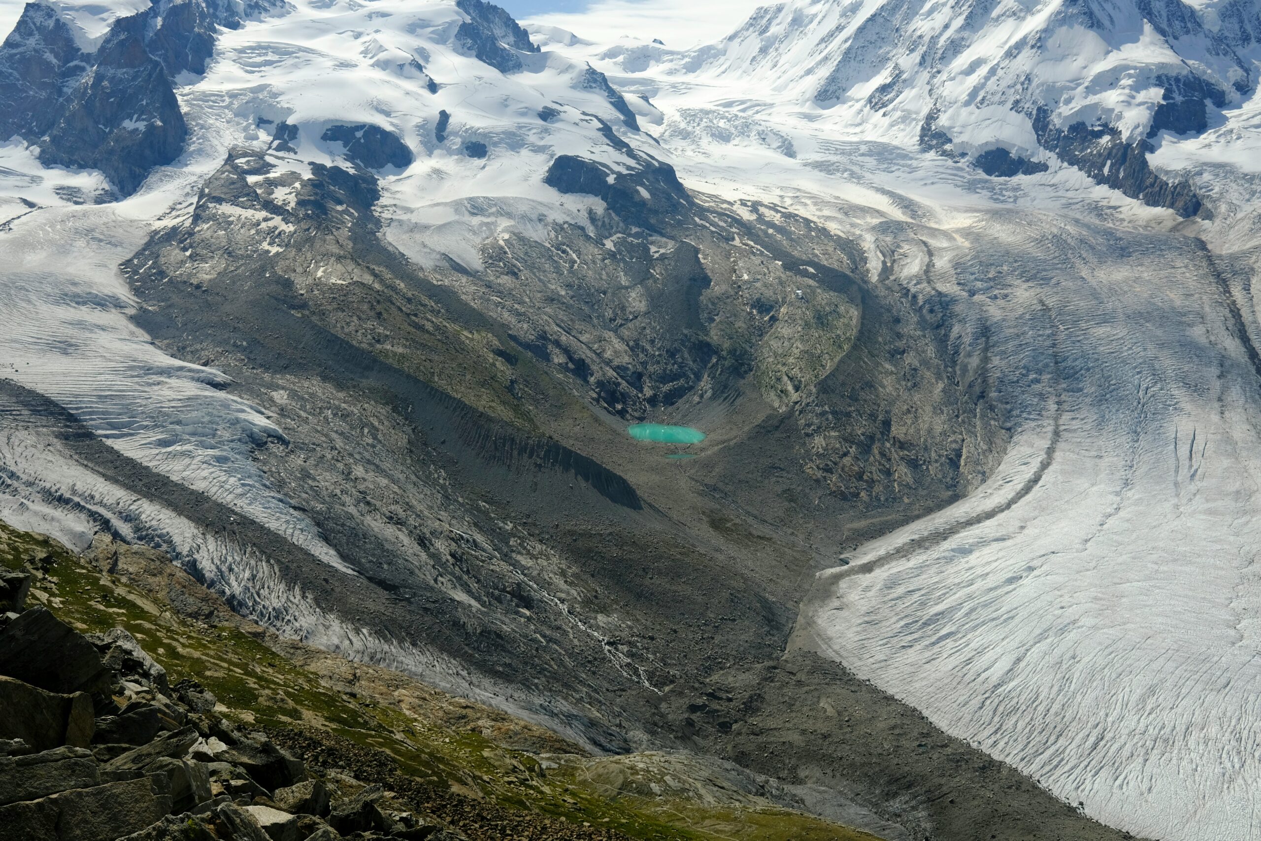
In the European Alps, extensive glaciation occurred during the LGM. Glacial valleys, U-shaped in cross-section, moraines, and erratics are ubiquitous evidence of this past ice cover. Mapping the LGM extent of these alpine glaciers helps understand how these mountain environments were transformed, impacting drainage systems, sediment transport, and the availability of ice-free refugia for flora and fauna. The limits of these ice masses can be inferred from the highest and most extensive moraine systems found in the alpine valleys.
High-Latitude Ice Caps: Greenland and Beyond
The Greenland Ice Sheet, although smaller than its LGM counterpart, was still a significant ice mass. Its extent during the LGM is well-documented through geological evidence on the surrounding landmasses and marine sediment cores containing ice-rafted debris. Other smaller ice caps likely existed in high-latitude mountainous regions in Siberia and Alaska, their extent inferred from glacial landforms and paleoclimatic reconstructions. The presence and extent of these high-latitude ice caps are crucial for understanding global sea level changes, as they contributed to ice volume and influenced regional atmospheric circulation.
Historical Geography: The Human Dimension of Glacial Landscapes
The mapping of LGM glacial boundaries is not solely an exercise in paleogeography; it is a fundamental tool for historical geographers seeking to understand the profound impact of these frozen landscapes on human history. The presence or absence of ice, the resulting sea-level changes, and the altered environments dictated the possibilities and limitations for early human migration, settlement, and resource utilization.
Migratory Pathways and Refuge Zones
The vast extent of the LGM ice sheets acted as significant barriers to human migration. In many regions, such as North America and Northern Europe, the ice sheets rendered large areas uninhabitable and impassable. Historical geographers study the reconstructed LGM boundaries to identify potential migratory routes, often following coastal areas or ice-free corridors that emerged during periods of glacial retreat. Conversely, ice-free areas, known as glacial refugia, became critical pockets where flora, fauna, and early human populations could survive during the harsh glacial conditions. The location and size of these refugia are directly informed by LGM ice extent maps.
Resource Availability and Environmental Pressures
The presence of extensive ice sheets dramatically altered resource availability. Large areas were covered by ice, rendering them unproductive for hunting and gathering. The expansion of tundra and steppe environments in ice-free regions created new ecological niches, influencing the types of game animals available and the plant resources that early humans could exploit. Historical geographers analyze LGM maps to understand how these environmental pressures shaped subsistence strategies, settlement patterns, and the development of cultural adaptations in different regions. For instance, areas adjacent to ice margins might have offered unique hunting opportunities for cold-adapted megafauna, influencing the migratory patterns of both humans and animals.
The Long Shadow of Glacial Legacy
Even after the ice retreated, its legacy continued to shape human history for millennia. The deposition of fertile glacial till, the creation of vast proglacial lake systems, and the altered drainage networks all influenced the course of human settlement and agricultural development. Understanding the LGM glacial boundaries provides a foundational context for comprehending the long-term geomorphic and environmental influences that underpinned the development of human societies in post-glacial landscapes.
Paleoclimate Modeling and the Future of LGM Reconstruction
The ongoing advancements in paleoclimate modeling, coupled with the ever-expanding datasets, are continuously refining our understanding of LGM ice sheet extents and dynamics. These models, grounded in the physical laws of climate and ice flow, can simulate glacial behavior under past climatic conditions, providing complementary insights to empirical data.
Simulating Ice Sheet Dynamics
Numerical ice sheet models can incorporate various parameters, such as temperature, precipitation, and bedrock properties, to simulate the growth, movement, and decay of ice sheets. By running these models with LGM climate forcing, researchers can generate simulated ice sheet configurations that can be compared with geological evidence. Discrepancies between model outputs and empirical reconstructions help to identify areas where our understanding is incomplete and guide future research. These simulations allow for a more dynamic understanding of how ice sheets responded to climatic shifts.
Integrating Diverse Data Streams
The future of LGM boundary reconstruction lies in the sophisticated integration of increasingly diverse data streams. This includes high-resolution satellite imagery for mapping glacial landforms, advanced computational techniques for analyzing sediment cores, and improved calibration of isotopic proxies. GIS platforms are crucial for integrating these disparate datasets into comprehensive paleogeographic reconstructions. The collaborative efforts of geologists, geographers, climatologists, and computational scientists are essential for pushing the boundaries of our knowledge.
Refining the Global Picture
By applying these advanced techniques, researchers are continually refining the global picture of LGM ice extent. This leads to more accurate estimates of global sea level during this period, a critical piece of information for understanding coastal geomorphology and the potential location of submerged archaeological sites. The ability to model past climate and ice sheet behavior also provides valuable insights into the sensitivity of Earth’s climate system to greenhouse gas concentrations, offering lessons for understanding future climate change. The ongoing pursuit of ever-more precise LGM ice boundary maps promises to unlock further secrets about our planet’s past and its potential future.

Beneath the Ice: Surviving the Ice Age 20,000 Years Ago
FAQs
What is the significance of studying ancient geography in relation to glacial maximum boundaries?
Studying ancient geography helps researchers understand how glaciers have expanded and retreated over time, providing valuable insights into past climate conditions and how they have influenced the Earth’s landscape.
How do scientists determine the boundaries of glacial maximums in ancient geography studies?
Scientists use a variety of methods, including analyzing sediment deposits, studying landforms shaped by glaciers, and examining ice core samples to determine the extent of glacial maximum boundaries in the past.
What can ancient geography studies tell us about the impact of glacial maximums on ancient civilizations?
Ancient geography studies can reveal how glacial maximums affected ancient civilizations by altering landscapes, influencing migration patterns, and potentially leading to the rise or fall of societies depending on their ability to adapt to changing environmental conditions.
How have advancements in technology improved our understanding of ancient geography and glacial maximum boundaries?
Advancements in technology, such as satellite imaging, LiDAR technology, and computer modeling, have allowed researchers to more accurately map ancient landscapes, track glacial movements, and reconstruct past climate conditions with greater precision than ever before.
What are some of the key findings that have emerged from ancient geography studies on glacial maximum boundaries?
Some key findings include evidence of ancient ice sheets covering vast areas, the impact of glacial meltwater on shaping landscapes, and the role of glacial maximums in influencing global climate patterns throughout history.