The colossal scale of humanity’s ancient endeavors, often appreciated through the lens of ground-level exploration, takes on an entirely new dimension when viewed from the silent, watchful gaze of space. Prehistoric monuments, the enduring testaments to our ancestors’ ingenuity, spiritual beliefs, and societal structures, reveal intricate patterns, vast alignments, and a profound connection to the landscape that are largely invisible to the naked eye. Aerial photography has long offered glimpses into this hidden geometry, but it is the perspective from orbit, a vantage point previously unimaginable for the builders of these megaliths, that truly unveils their cosmic connections and the astonishing organizational capabilities of early civilizations. These structures, sculpted from stone, earth, and sheer willpower, become intricate artworks etched onto the face of the planet, their full magnificence only becoming apparent when one can perceive the entire canvas.
From the sterile vacuum of space, the Earth appears as a vibrant, living entity, a celestial sphere in its own right, constantly in dialogue with the sun, moon, and stars. Prehistoric peoples, intimately attuned to these cosmic rhythms, meticulously incorporated astronomical observations into their monumental constructions. The vantage point of orbit allows us to see these alignments not as isolated features, but as integral parts of a larger, planet-wide system designed to track celestial movements, predict seasons, and perhaps even interpret the divine will. The sheer scale of these structures, when seen from above, underscores the immense effort and sophisticated understanding required to achieve such precision.
Stonehenge: A Cosmic Dial on the Salisbury Plain
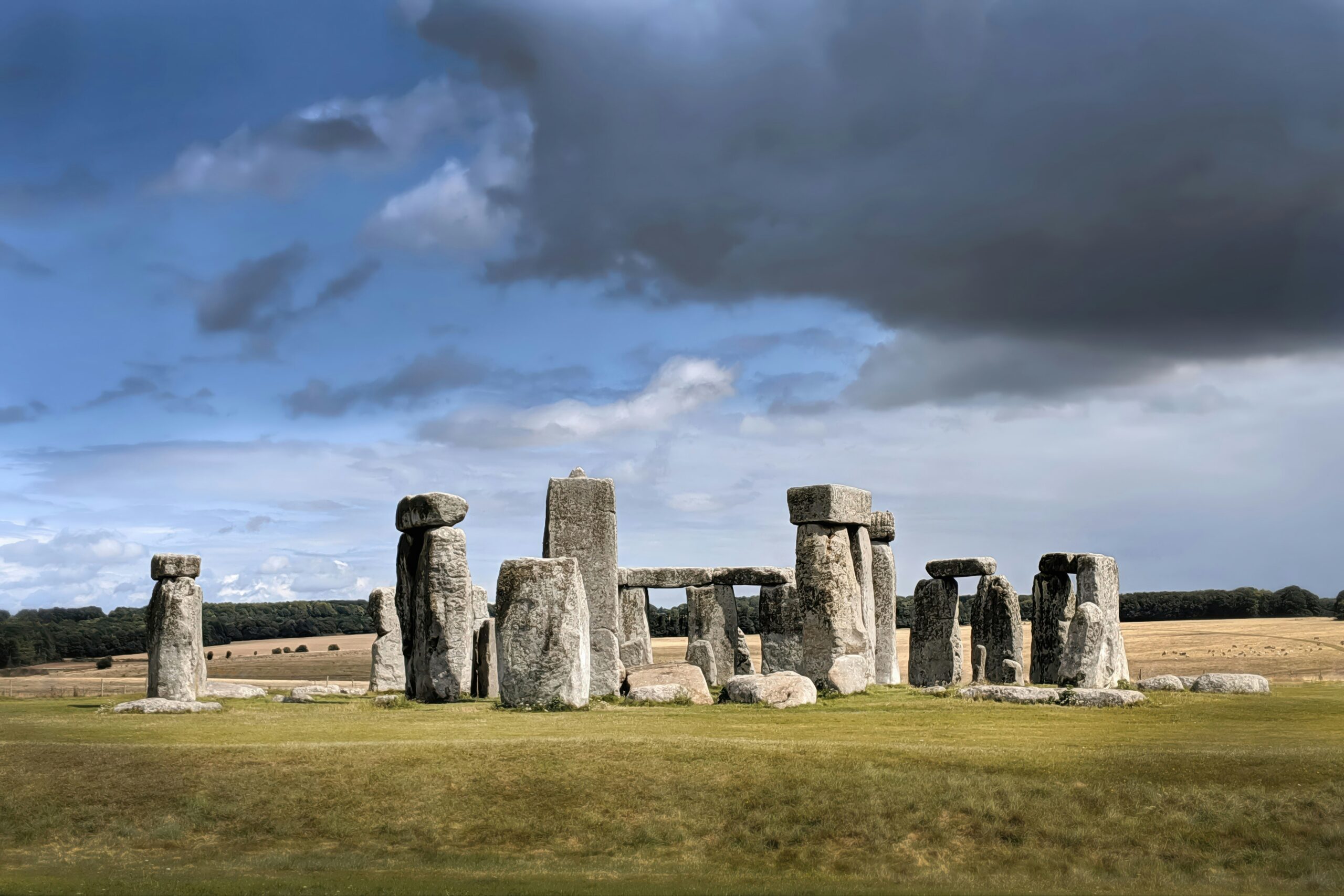
The iconic stones of Stonehenge, when observed from orbit, transform from a collection of enigmatic monoliths into a precisely calibrated instrument. The famous solar alignments, meticulously documented by ground-based archaeologists, are amplified by the overhead view. The solstice sunrise and sunset points, marked by specific sarsen stones and the ditch and bank, become clear indicators of a monumental calendar. But the view from space hints at more: the possibility of lunar alignments, tracking the moon’s cycles and possibly its more complex nodal points, adding another layer to Stonehenge’s function as a celestial observatory. The subtle variations in stone orientation, imperceptible at ground level, become apparent when the entire monument is laid out beneath a satellite’s lens, suggesting a deeper understanding of lunar phases and their influence on terrestrial events. The surrounding landscape, with its avenues and other earthworks, further emphasizes the integral role of Stonehenge within a wider ceremonial landscape, its cosmic purpose extending beyond the immediate stone circle. The precise positioning of the sarsen trilithons and bluestones, when viewed from an elevated perspective, suggests a deliberate integration of different astronomical phenomena, perhaps even encompassing eclipses or the positions of other celestial bodies. The sheer effort involved in transporting and erecting these massive stones, when juxtaposed with the precise astronomical functions they served, speaks volumes about the advanced knowledge and social organization of the Neolithic people who constructed this masterpiece. The earthworks surrounding Stonehenge, often overlooked in discussions focused solely on the stones, become significant features from space, outlining pathways and enclosures that further hint at the monument’s role in a broader ritualistic and astronomical context.
Nabta Playa: Desert Geometry and Solar Worship in the Sahara
In the vast expanse of the Egyptian Sahara, far from the familiar monuments of the Nile Valley, lies Nabta Playa, a testament to early desert dwellers’ astronomical prowess. From space, the site reveals a complex arrangement of stone circles and alignments that echo the sophistication of Stonehenge, albeit in a more arid and ephemeral setting. The “astronomical calendar” at Nabta Playa, marked by megaliths oriented towards specific stars and solstices, demonstrates a profound connection to the celestial sphere even in this harsh environment. The subtle curvature of some alignments, visible from orbit, suggests a nuanced understanding of astronomical cycles that goes beyond simple seasonal markers. The presence of what appear to be wells and water channels, integrated with the stone structures, further hints at the multi-functional nature of these prehistoric sites, where astronomical observation was likely intertwined with survival and resource management. The alignment of certain stones with the heliacal rising of Sirius, a star of immense importance in ancient Egyptian cosmology, suggests a long-standing tradition of celestial observation that predates the pharaohs. The sheer scale of the Nabta Playa complex, spread across a significant area of the desert, indicates a communal effort and a shared understanding of astronomical principles that transcended individual needs. The subtle patterns in the arrangement of stones, when viewed from above, reveal a deliberate and intricate design, suggesting that these were not random placements but rather carefully orchestrated elements of a larger astronomical system. The integration of natural features, such as rock outcrops and topographical changes, into the alignments further underscores the builders’ deep understanding of their environment and its connection to the cosmos.
Recent advancements in satellite imagery have allowed researchers to uncover prehistoric monuments that were previously hidden from view. These ancient structures, which include burial mounds and stone circles, provide valuable insights into the cultures that built them. For a deeper understanding of how ancient societies communicated and negotiated, you might find the article on the art of diplomatic language in ancient politics particularly interesting. You can read it here: The Art of Diplomatic Language in Ancient Politics.
The Grand Design: Earthworks, Enclosures, and Landscape Integration
The perspective from space reveals that many prehistoric monuments were not isolated structures but rather integral components of a larger, meticulously planned landscape. Enormous earthworks, intricate patterns of ditches and mounds, and carefully chosen geographical locations all speak to a holistic approach to monumentality that aimed to integrate human activity with the natural world and its cosmic rhythms. These earthworks, often dismissed as mere agricultural features or defensive structures from ground level, reveal themselves from orbit as deliberate designs, their scale and precision indicative of sophisticated societal organization and a profound understanding of their environment.
Avebury: A Megalithic Landscape Unveiled
While Stonehenge is known for its stone circle, Avebury, also in Wiltshire, England, presents a different kind of megalithic spectacle. From space, the sheer scale of Avebury’s henge monument – a massive ditch and bank encircling a vast area – becomes strikingly apparent. This colossal earthwork, combined with its inner stone circles, demonstrates a landscape-level approach to monumental construction. The alignment of the main avenue leading to the monument, visible as a subtle scar on the land from orbit, further emphasizes the integration of these structures with the surrounding geography. The dispersed nature of Avebury’s stones, some of which are still visible from space as isolated points, highlights its unique integration into the broader agricultural and settlement patterns of the time. The surrounding countryside, with its network of ancient trackways and burial mounds, paints a picture of a vibrant and active prehistoric landscape, with Avebury serving as a focal point for communal activity and ritual. The immense labor involved in constructing the ditch and bank, which would have required the movement of thousands of tons of earth, speaks to a highly organized society capable of mobilizing large labor forces for communal projects. The concentric arrangement of the ditches and banks, when seen from orbit, reveals a deliberate and symmetrical design, suggesting a sophisticated understanding of geometry and engineering. The careful selection of the henge’s location, on a prominent plateau with commanding views of the surrounding countryside, further underscores the monument’s importance as a focal point within the landscape. The subtle variations in the earthworks, such as the presence of causeways and internal divisions, suggest a complex and nuanced internal organization of the space, likely reflecting different ceremonial functions.
The Giant’s Causeway: A Volcanic Symphony in Stone
While geologically a natural phenomenon, the Giant’s Causeway in Northern Ireland, with its thousands of interlocking basalt columns, has been imbued with human myth and legend for millennia. From the perspective of space, the ordered hexagonal patterns of the columns, stretching across the coastline, take on an almost artificial regularity. While not built by human hands in the same way as Stonehenge, the very existence of such a striking natural formation likely influenced prehistoric beliefs and practices. The visible extent of the causeway along the coast, and its apparent connection to the surrounding cliffs and sea, suggests that its perception by early inhabitants was as a grand, imposing feature of the natural world, one that undoubtedly inspired awe and wonder. The way the columns emerge from the sea and recede into the land, a continuous natural structure, would have presented a powerful and enduring image to early peoples, likely shaping their mythology and understanding of the world. The ordered, geometric nature of the basalt columns, even from space, is remarkable and hints at the underlying geological forces that shaped them. This natural wonder, when viewed from above, appears as an extraordinary piece of natural architecture, a powerful reminder of the forces that shape our planet and the enduring human tendency to find meaning and order in the natural world.
Subterranean Secrets: Unearthing Hidden Earthworks
While many prehistoric monuments are characterized by their imposing above-ground structures, a significant number also involve extensive subterranean construction or leave subtle traces in the earth that are only fully appreciated from an aerial perspective. These hidden earthworks, often invisible to the casual observer on the ground, reveal the depth of planning and the diverse techniques employed by prehistoric builders. Satellite imagery and advanced remote sensing technologies allow us to peel back the layers of time and uncover these buried secrets, revealing the full scope of ancient human endeavors.
Skara Brae: Neolithic Village Layout Revealed
The well-preserved Neolithic settlement of Skara Brae in Orkney, Scotland, provides a unique glimpse into prehistoric domestic life. From space, the cluster of interconnected stone dwellings, their roofs long since gone, forms a distinct pattern within the landscape. The subtle depressions and mounds that mark the outlines of these ancient homes, along with the visible remains of their stone walls, are amplified by the elevated view. The layout of the village, with its central pathways and the arrangement of individual dwellings, becomes clear, showcasing a sense of community and shared living. The surrounding fields and potential defensive ditches, also visible from orbit, further contextualize Skara Brae as an organized and self-sufficient settlement. The careful arrangement of the houses, their proximity to each other and to the common areas, speaks to a structured social organization and a strong sense of community. The integration of the settlement with the surrounding agricultural landscape, with evidence of field systems and pathways, highlights the interconnectedness of prehistoric life. The visible remains of the “streets” and communal areas within the village, when seen from above, emphasize the communal nature of life at Skara Brae. The precise positioning of the dwellings, facing inwards towards a central point, suggests a deliberate design for both social interaction and potential defense.
Hillforts: Defensive Landscapes from a Bird’s-Eye View
Across Europe, numerous hillforts represent some of the most impressive feats of prehistoric earthwork construction. From the vantage point of space, the concentric rings of ditches and ramparts that define these defensive settlements become astonishingly clear. These formidable earthworks, designed to protect communities and their resources, reveal a sophisticated understanding of military engineering and landscape utilization. The sheer scale of many hillforts, such as Maiden Castle in Dorset, England, or the Hill of Tara in Ireland, is truly breathtaking when viewed from orbit. The careful selection of elevated positions, combined with the layered defenses, underscores the strategic thinking and organizational capabilities of these ancient societies. The relationship between the hillforts and the surrounding landscape, including pathways and potential agricultural lands, further illuminates their role as centers of power and community. The multiple lines of defense, often with intricate gateways and internal divisions, speak to a complex understanding of siege warfare and defensive strategy. The visible extent of the earthworks, sometimes covering several acres, highlights the immense labor and coordination required for their construction. The integration of natural topographical features, such as steep slopes and cliff edges, into the defensive plans demonstrates a keen awareness of the environment and its strategic potential. The subtle variations in the earthworks, such as the presence of internal structures and living areas, offer clues about the social organization and daily life within these fortified settlements.
The Sacred Geometry: Patterns and Motifs from Above
Beyond specific alignments and earthworks, the perspective from space often reveals a recurring appreciation for geometric patterns and symbolic motifs in prehistoric monumental architecture. These patterns, whether consciously intended or emergent from the construction process, hint at a deeper understanding of form, proportion, and perhaps even a spiritual connection to the universe. From orbit, these geometric arrangements are not confined to individual sites but can be seen as part of a broader visual language that spanned vast distances and cultures.
The Nazca Lines: Desert Etchings of Cosmic Significance
Perhaps the most famous examples of large-scale geometric art are the Nazca Lines in Peru. These immense geoglyphs, etched into the desert floor, depict animals, plants, and geometric shapes that are only truly appreciated from a significant elevation. From space, the intricate details and the sheer scale of these designs become undeniable. The precise straight lines, spirals, and trapezoids, stretching for miles, suggest a sophisticated understanding of surveying and a profound connection to the earth and sky. While their exact purpose remains debated, the aerial view offers undeniable evidence of their monumental artistic and possibly ritualistic significance. The clarity of the lines from orbit, their clean edges and precise curves, suggest a level of artistic skill and planning that is astounding. The integration of these geoglyphs with the surrounding landscape, their careful placement in relation to geographical features, further adds to their mystery and potential meaning. The remarkable preservation of these designs, due to the arid climate, allows us to witness them in a form that has endured for millennia. The sheer number and variety of the geoglyphs, from simple geometric shapes to complex depictions of animals, suggest a rich symbolic language and a deep connection to the natural world. The possibility that these lines served as astronomical markers, guiding lines for celestial observation, or even as ritualistic pathways, remains a compelling avenue of research, with the aerial perspective providing crucial evidence for such theories.
The Megalithic Art of Orkney: Symbolism in Stone
The Neolithic sites of Orkney, particularly those on the Mainland island, are renowned for their intricate stone carvings. While these carvings are detailed works of art at ground level, the aerial perspective can reveal how they are integrated into the larger structures and landscapes. The symmetrical patterns and abstract motifs found at sites like the Ring of Brodgar or the Stones of Stenness, when viewed from above, can suggest a deliberate design that echoes celestial arrangements or natural forms. The precise repetition of certain symbols, and their placement within ceremonial circles, hints at a symbolic language that may have conveyed complex cosmological ideas. The connection between the stone circles themselves, and the subtle geometric arrangements within them, can be seen as a deliberate attempt to replicate or invoke cosmic order on the terrestrial plane. The presence of similar carved motifs across different sites in Orkney, and even further afield, suggests a shared cultural understanding and a common symbolic repertoire. The careful alignment of the stone circles, and the orientation of the carved stones within them, can further enhance the interpretation of these symbols as having astronomical or cosmological significance. The sheer artistry and precision of the carvings, when viewed from an elevated perspective, underscore the importance of these symbols to the Neolithic people of Orkney.
Recent advancements in satellite technology have allowed researchers to explore prehistoric monuments from a unique perspective, revealing insights into ancient civilizations that were previously hidden from view. A fascinating article discusses how these aerial observations have transformed our understanding of historical sites and their significance. For more information on how modern technology is reshaping our knowledge of the past, you can read the full article here.
The Unifying Thread: Global Perspectives and Future Discoveries
| Monument | Location | Type | Size |
|---|---|---|---|
| Stonehenge | England | Stone Circle | 110 meters in diameter |
| Nazca Lines | Peru | Geoglyphs | Various sizes |
| Giza Pyramids | Egypt | Pyramids | Great Pyramid: 146.6 meters |
| Avebury Stone Circle | England | Stone Circle | 335 meters in diameter |
The exploration of prehistoric monuments from space offers more than just stunning visuals; it provides a unifying thread that connects diverse cultures and time periods across the globe. By examining these ancient sites from a common, elevated perspective, we can begin to identify shared principles, common aspirations, and a universal human drive to understand our place in the cosmos. The ongoing advancements in satellite technology and remote sensing promise even greater discoveries, allowing us to unearth previously unknown sites and to re-evaluate our understanding of those we already know. The silent witness of space continues to reveal the enduring legacy of our ancestors, a legacy etched into the very fabric of our planet.
New Frontiers in Archaeology: LiDAR and Remote Sensing
The advent of technologies like LiDAR (Light Detection and Ranging) has revolutionized our ability to see the past. By penetrating dense vegetation and mapping subtle topographical changes, LiDAR allows archaeologists to discover and document prehistoric sites that would otherwise remain hidden. When combined with satellite imagery, these technologies create a powerful toolkit for exploring the planet’s ancient past from an unparalleled perspective. The ability to create detailed 3D models of these sites from aerial data allows for a more comprehensive understanding of their scale, complexity, and relationship to the surrounding environment. The identification of previously unknown earthworks, alignments, and settlement patterns through these techniques is opening up entirely new avenues of research and challenging long-held assumptions about prehistoric societies. The non-invasive nature of these technologies also allows for the preservation of fragile archaeological sites, as they minimize the need for physical excavation. The global reach of satellite-based remote sensing means that these discoveries can be made across vast and diverse landscapes, offering a truly planetary perspective on human history.
A Cosmic Legacy: Inspiring Future Generations
The awe-inspiring images of prehistoric monuments viewed from space serve as a powerful reminder of humanity’s enduring curiosity and our innate desire to connect with something larger than ourselves. These ancient structures, built with ingenuity and dedication, speak to a shared human heritage that transcends time and borders. By continuing to explore and understand these monumental achievements, we not only gain a deeper appreciation for our past but also inspire future generations to look to the stars and to marvel at the wonders that lie both above and below. The lessons learned from these ancient builders – their understanding of astronomy, their connection to the land, and their capacity for communal endeavor – remain relevant today, offering insights into sustainable living, societal organization, and the profound beauty of the natural world. The ongoing exploration of these sites from the unique vantage point of space continues to reveal the depth and breadth of our collective human story, a story written in stone and etched into the very landscape of our planet.

260 Ancient Graves Were Hiding in This “Empty” Desert
FAQs
What are prehistoric monuments?
Prehistoric monuments are structures or sites that were built by ancient civilizations or cultures before recorded history. These monuments can include stone circles, burial mounds, and other structures that were created for religious, ceremonial, or practical purposes.
How are prehistoric monuments seen from space?
Prehistoric monuments can be seen from space using satellite imagery and aerial photography. These technologies allow researchers to identify and study ancient sites from a bird’s-eye view, providing new insights into the layout and organization of these monuments.
What can we learn from studying prehistoric monuments from space?
Studying prehistoric monuments from space can provide valuable information about the ancient civilizations that built them. Researchers can analyze the layout and orientation of these sites, as well as their relationship to the surrounding landscape, to gain a better understanding of the cultural and religious practices of the people who constructed them.
What are some examples of prehistoric monuments that have been studied from space?
Some examples of prehistoric monuments that have been studied from space include Stonehenge in England, the Nazca Lines in Peru, and the Great Pyramids of Giza in Egypt. These iconic sites have been the subject of extensive research using satellite imagery and aerial photography.
Why is studying prehistoric monuments from space important?
Studying prehistoric monuments from space is important because it allows researchers to gain new perspectives on these ancient sites. By using advanced technologies to analyze these monuments from above, scientists and archaeologists can uncover new information about the people who built them and the societies they lived in. This research can help to preserve and protect these important cultural heritage sites for future generations.