The very act of charting the known world is an ancient human impulse, a desire to comprehend our place within the vastness of existence and to navigate the unfamiliar. From crude sketches etched onto clay tablets to the sophisticated digital projections of today, maps have served as indispensable tools for exploration, trade, governance, and understanding. The evolution of world maps is not merely a history of cartography; it is a reflection of humanity’s growing knowledge, its changing perspectives, and its ever-increasing interaction with the globe.
Long before the concept of a truly accurate global representation, early civilizations grappled with depicting their immediate surroundings and their perceived world. These initial cartographic efforts were born out of practical necessity and a limited understanding of the Earth’s true scale and form.
Babylonian and Egyptian Contributions
The earliest surviving maps date back to ancient Mesopotamia. The Babylonian Map of the World, inscribed on a clay tablet around the 6th century BCE, provides a fascinating glimpse into Babylonian cosmology. It depicts a disc-shaped Earth surrounded by a ring of water, with Babylon at its center. Mountains are represented by triangular shapes, and cities by small circles. While not geographically accurate by modern standards, it reflects their understanding of the divine order and the perceived boundaries of their world.
Similarly, ancient Egyptians created rudimentary maps, often found on papyrus or tomb walls, primarily for administrative and land surveying purposes. These maps focused on the Nile River and its fertile banks, crucial for agriculture and livelihood. They displayed property boundaries, canals, and sometimes even topographical features, serving as vital tools for royal surveyors and tax collectors. Their focus was intensely local, a testament to their geographically defined civilization.
The Greeks and the Birth of Mathematical Geography
The ancient Greeks marked a significant turning point in the evolution of world maps. Their intellectual curiosity and development of mathematical and philosophical thought laid the groundwork for more systematic and reasoned approaches to geography.
Anaximander and the Earliest Known Globe
Often credited with creating one of the earliest known world maps, Anaximander of Miletus (c. 610 – c. 546 BCE) envisioned the Earth as a cylinder suspended in space. His map, though lost, is described by later writers as a disc, with the known world—Greece at its center—surrounded by the ocean. This was a conceptual leap, moving beyond mere depiction to an attempt at a reasoned, albeit abstract, representation.
Hecataeus of Miletus and the Periodos Ges
Hecataeus of Miletus (c. 550 – c. 476 BCE) built upon Anaximander’s work with his Periodos Ges (Journey Around the Earth). This was a more detailed and systematic description of the known world, accompanied by a map that attempted to depict landmasses and geographical features with greater precision. He categorized regions and peoples, laying the foundation for a more ethnographic approach to geography.
Eratosthenes and the First Measurement of the Earth
One of the most remarkable achievements in ancient cartography came from Eratosthenes of Cyrene (c. 276 – c. 195/194 BCE). A brilliant mathematician and geographer, he is credited with being the first to calculate the circumference of the Earth with remarkable accuracy. Furthermore, he developed a system of latitude and longitude lines, a foundational concept for all subsequent mapmaking. His map, while based on limited data and prone to inaccuracies, was the first to attempt a rational, grid-based representation of the entire known world, dividing it into regions and using estimated distances.
Ptolemy and the “Geographia”
Claudius Ptolemy (c. 100 – c. 170 CE), a mathematician, astronomer, and geographer living in Roman Egypt, produced a monumental work titled Geographia. This treatise contained detailed instructions on how to construct maps and included coordinates for thousands of known locations, based on astronomical observations and textual sources. Ptolemy’s work, though flawed (he underestimated the Earth’s circumference and placed Southeast Asia far to the east, believing it connected to Africa), became the authoritative geographical text in Europe for over a millennium. His advocacy of projection methods was particularly influential, attempting to translate a spherical Earth onto a flat surface, a challenge cartographers continue to address.
The history of world maps is a fascinating journey that reflects the evolution of human understanding and exploration. For those interested in the intersection of ancient civilizations and their technological advancements, a related article can be found at Unbelievable Ancient Advanced Technology. This article delves into the remarkable achievements of ancient cultures, providing context for how their innovations influenced cartography and our perception of the world.
The Middle Ages: Preservation, Islamic Golden Age, and Renewed Exploration
The fall of the Western Roman Empire led to a period of fragmentation and a decline in scientific inquiry in Europe. However, the flame of geographical knowledge was kept alive and even advanced in other parts of the world, particularly in the Islamic world.
The “T-O” Maps: A Medieval Worldview
During the European Middle Ages, most world maps were vastly different from the geographically ambitious works of the Greeks. The dominant form was the “T-O” map. These were highly schematic and religiously influenced representations.
Structure and Symbolism
The “T-O” map depicted the world as a disc – the “O” – surrounded by the encircling ocean. The landmass was divided by a “T” shape, representing the Mediterranean Sea (the horizontal bar) and the rivers Nile and Don (the vertical bar). The three known continents – Asia (top), Europe (left), and Africa (right) – were thus organized. Jerusalem was often placed at the center, reflecting the Christian worldview. These maps were not meant for navigation or accurate representation but served as didactic tools to illustrate biblical narratives and the perceived order of creation.
Limitations and Purpose
These maps provided a cosmographical rather than geographical understanding of the world. They were simple, symbolic, and reflected a limited understanding of global geography. Despite their limitations, they were widely distributed and served as the primary visual representation of the world for centuries in Christian Europe.
The Islamic Golden Age: Rediscovery and Refinement
While Europe was in the grip of what is sometimes called the “Dark Ages,” the Islamic Golden Age (roughly 8th to 14th centuries) witnessed a flourishing of intellectual and scientific pursuits. Islamic scholars actively translated and preserved Greek texts, including Ptolemy’s Geographia, and made significant advancements in various fields, including geography and cartography.
Al-Idrisi and the “Tabula Rogeriana”
Muhammad al-Idrisi (c. 1100 – c. 1165/1166) was a cartographer and geographer who worked for King Roger II of Sicily. His magnum opus, the Tabula Rogeriana (or the “Nudhah al-Mushtaq fi Ikhtiraq al-Afaq,” meaning “The Delight of the Man Who Yearns to Traverse the Regions of the World”), was a comprehensive geographical encyclopedia accompanied by a world map.
A World Portrait on a Silver Disc
Al-Idrisi’s map was a remarkable achievement for its time. Based on extensive research, traveler accounts, and his own surveys, it depicted the world with greater detail and accuracy than most European maps of the era. He divided the world into seven climate zones and 70 administrative divisions (regions). The map itself was originally engraved on a silver disc, a testament to its importance and the wealth of its patron. It showed a more extensive world than previously understood, including parts of sub-Saharan Africa and Scandinavia, with a greater appreciation for the interconnectedness of land and sea.
Arabic Cartography and Islamic Worldview
Throughout the Islamic world, maps were created and used for various purposes, including trade, pilgrimage, and administrative planning. Arab cartographers were skilled in using latitude and longitude and incorporated astronomical data into their work. Their maps often reflected a more interconnected world, demonstrating awareness of routes between Asia, Africa, and Europe, crucial for the thriving Silk Road and maritime trade networks.
The Age of Exploration: Charting the Unknown
Starting in the 15th century, a period of unprecedented maritime exploration, driven by a thirst for new trade routes, resources, and knowledge, began to reshape the world map. European powers, armed with improved navigational tools and shipbuilding techniques, embarked on ambitious voyages that would fundamentally alter human understanding of the Earth’s geography.
Early Portuguese and Spanish Voyages
The voyages of Vasco da Gama, Christopher Columbus, and Ferdinand Magellan were pivotal. Da Gama’s journey around the Cape of Good Hope opened a sea route to India, transforming global trade. Columbus’s landing in the Americas, though initially believed to be Asia, heralded a new era of transatlantic contact and discovery. Magellan’s circumnavigation of the globe provided undeniable proof of the Earth’s spherical nature and its vastness.
The Impact on Cartography
These voyages generated a flood of new geographical information. Cartographers scrambled to incorporate these discoveries into their maps. Early maps of the “New World” were often speculative, based on fragmented reports and legends. However, with each returning expedition, the outlines of continents became clearer, and familiar coastlines began to take shape on paper.
The Renaissance and the Era of Accurate Mapping
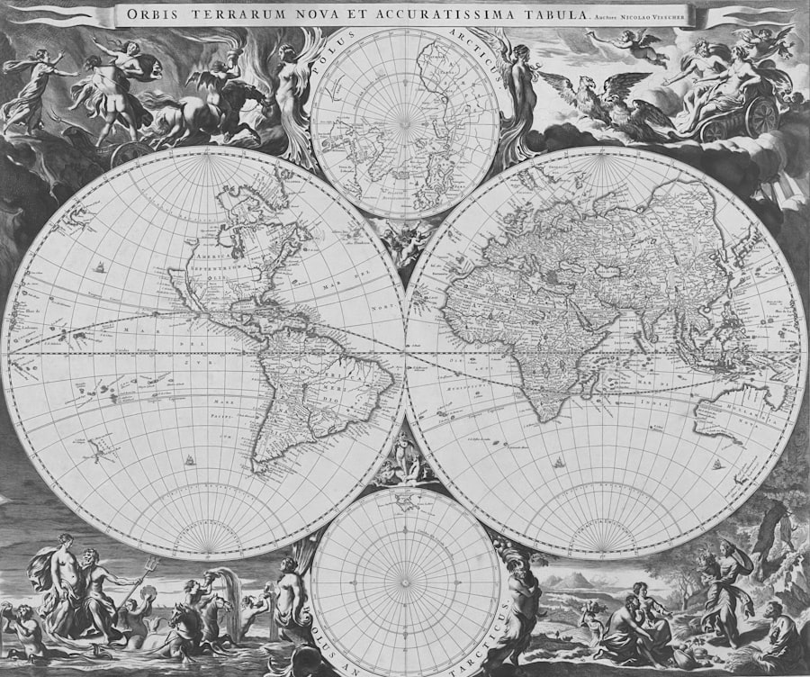
The Renaissance, a period of profound cultural and intellectual rebirth in Europe, coincided with and was fueled by the Age of Exploration. This era saw a renewed interest in classical learning, scientific inquiry, and artistic innovation, all of which had a transformative impact on cartography.
The Rediscovery of Ptolemy and its Influence
The rediscovery of Ptolemy’s Geographia in the West, particularly its translation into Latin in the early 15th century, was a watershed moment. It provided a systematic framework and a wealth of geographical data that cartographers could build upon. However, it also presented a challenge: how to reconcile Ptolemy’s ancient descriptions with the new discoveries of the Age of Exploration.
Antwerp and the Rise of a Cartographic Hub
Cities like Antwerp became vibrant centers of cartography. Publishers and engravers like Gerardus Mercator and Abraham Ortelius produced some of the most influential maps of the Renaissance. They benefited from the influx of new information from explorers, the availability of advanced printing techniques, and a growing demand for maps from merchants, navigators, and rulers.
Mercator and the Projection Revolution
Gerardus Mercator (1512-1594) was a towering figure in Renaissance cartography. His most enduring legacy is the Mercator projection, first published in 1569.
The Mercator Projection and its Significance
The Mercator projection’s genius lay in its ability to represent the Earth’s surface on a flat plane while preserving conformality. This means that shapes of small areas are preserved, and angles are accurate. Crucially for navigators, rhumb lines (lines of constant compass bearing) are straight lines on a Mercator map. This made it an invaluable tool for maritime navigation, allowing sailors to plot courses with unprecedented ease and accuracy.
However, the Mercator projection has a significant distortion of area, especially at higher latitudes. Continents and landmasses at the poles appear much larger than they are relative to the equator. Despite this distortion, its navigational utility ensured its dominance for centuries. Mercator also produced his own world atlas, which further popularized and standardized geographical knowledge.
Ortelius and the First Modern Atlas
Abraham Ortelius (1527-1598) is often credited with creating the first modern atlas, the Theatrum Orbis Terrarum (Theatre of the World), published in 1570.
Content, Scope, and Impact
Ortelius’s atlas was a collection of maps drawn from various sources, accompanied by descriptive text. It was a significant step towards standardizing geographical knowledge and making it accessible to a wider audience. His maps were celebrated for their accuracy and artistic beauty, and the atlas was so successful that it went through numerous editions and was translated into several languages. The Theatrum Orbis Terrarum became a model for future atlases and played a crucial role in disseminating geographical information across Europe.
The Age of Enlightenment and Scientific Cartography

The Age of Enlightenment, characterized by reason, empiricism, and a spirit of scientific inquiry, further transformed cartography into a more precise and scientific discipline.
The Rise of National Surveys
The growing power of nation-states led to a demand for accurate maps for military, administrative, and economic purposes. This gave rise to ambitious national survey projects.
Cadastral Maps and Geodetic Surveys
Countries began undertaking systematic cadastral surveys to meticulously map land ownership and boundaries. Simultaneously, geodetic surveys, employing sophisticated astronomical calculations and triangulation techniques, aimed to precisely measure the Earth’s curvature and establish a network of accurate control points.
France’s Cassini Map
A prime example of this trend is the Géographie de Cassini, a monumental undertaking in France led by the Cassini family. Over a century, from the mid-18th to the mid-19th century, they produced a series of highly detailed topographic maps of France, covering the entire country at a scale of 1:86,400. This was an unparalleled achievement in its accuracy and coverage, serving as a model for national mapping efforts worldwide.
Improvements in Projection and Representation
While the Mercator projection remained popular for navigation, cartographers continued to grapple with the inherent distortions when representing a spherical Earth on a flat surface. The Enlightenment saw the development and refinement of various map projections, each with its own strengths and weaknesses, catering to different needs.
Equal-Area and Conformal Projections
Cartographers explored equal-area projections, which preserve the relative size of landmasses but distort shapes and angles, and conformal projections, which preserve angles and shapes but distort area. Understanding these mathematical principles allowed for more informed choices in map design, depending on the intended use of the map.
The Scientific Exploration of the Globe
Enlightenment thinkers sponsored expeditions to explore and map hitherto unknown regions of the world with a much greater scientific rigor.
Expeditions of Cook, La Pérouse, and Humboldt
The voyages of Captain James Cook in the Pacific provided incredibly accurate charts of new coastlines. Explorers like Jean-François de Galaup, Comte de La Pérouse, undertook systematic charting of coastlines and explored the natural world. Alexander von Humboldt’s extensive travels in the Americas and his subsequent scientific analysis had a profound impact on understanding the Earth’s physical geography. These expeditions generated vast quantities of data, which were then meticulously incorporated into new world maps, progressively filling in the blanks and correcting ancient errors.
The evolution of world maps has been a fascinating journey that reflects not only geographical knowledge but also cultural and political changes throughout history. For those interested in understanding how economic factors influence global perspectives, a related article discusses the potential for Mexico’s economy to surpass that of the United States. You can explore this intriguing topic further by visiting this link, which provides insights into how economic shifts can reshape our understanding of world geography.
The Digital Revolution and the Future of Maps
| Year | Event |
|---|---|
| 6th century BC | First known world map created by Anaximander |
| 2nd century AD | Creation of Ptolemy’s world map, which influenced mapmaking for centuries |
| 15th century | Age of Exploration leads to more accurate world maps |
| 16th century | Mercator projection developed, revolutionizing navigation |
| 20th century | Advancements in technology lead to highly detailed and accurate world maps |
The 20th and 21st centuries have witnessed a rapid and ongoing revolution in cartography, driven by technological advancements, particularly in computing and satellite technology.
Satellite Imagery and Global Positioning Systems (GPS)
The advent of aerial photography and later satellite imagery provided an entirely new perspective on the Earth’s surface. Satellites can capture vast areas of the globe with remarkable detail and accuracy, providing data for creating highly precise maps.
High-Resolution Data and Orthophotos
The ability to capture high-resolution imagery and create orthophotos (aerial photographs that have been geometrically corrected to remove distortion) has allowed for the creation of maps that are far more accurate and detailed than ever before. This data is crucial for a wide range of applications, from urban planning and environmental monitoring to disaster management.
The development of the Global Positioning System (GPS), initially a military technology, has democratized precise location-finding. GPS receivers, now ubiquitous in smartphones and vehicles, allow for real-time tracking and data collection, enabling the creation of dynamic and interactive maps.
Geographic Information Systems (GIS)
Geographic Information Systems (GIS) represent a paradigm shift in how we create, manage, analyze, and display geographical data. GIS software allows users to layer different types of data onto a map – such as elevation, population density, transportation networks, and environmental information – and analyze the spatial relationships between them.
Data Integration and Spatial Analysis
GIS has transformed mapmaking from a purely representational art to a powerful analytical tool. It enables complex spatial analysis, pattern recognition, and predictive modeling, leading to more informed decision-making in fields ranging from urban development and resource management to public health and environmental conservation.
Interactive and Dynamic Mapping
The digital age has ushered in an era of interactive and dynamic maps. Websites and applications allow users to zoom, pan, and explore maps in ways that were previously unimaginable.
Online Mapping Services and User-Generated Content
Services like Google Maps and OpenStreetMap have made detailed maps accessible to billions worldwide. These platforms are constantly updated with new information, often incorporating user-generated content (e.g., traffic information, reviews of businesses). This collaborative approach to mapping is continually refining our understanding of the planet. The future of maps likely lies in ever-increasing interactivity, real-time data integration, and personalized mapping experiences, blurring the lines between static representations and dynamic, living information about our world.

7 Ancient Maps That Remember What We Forgot
FAQs
What is the history of world maps?
World maps have been used for thousands of years to help people navigate and understand the world around them. The earliest known world map is from ancient Babylon, dating back to the 6th century BCE.
How have world maps evolved over time?
World maps have evolved from simple, symbolic representations to more accurate and detailed depictions of the Earth’s geography. They have been influenced by advancements in technology, exploration, and cartography.
Who were some key figures in the history of world maps?
Key figures in the history of world maps include Ptolemy, who created one of the most influential world maps in the 2nd century CE, and Gerardus Mercator, who developed the Mercator projection in the 16th century.
What are some significant world maps throughout history?
Significant world maps throughout history include the Ptolemaic world map, the Tabula Rogeriana created by Muhammad al-Idrisi, and the Waldseemüller map, which was the first to use the term “America” to refer to the New World.
How have world maps impacted our understanding of the world?
World maps have played a crucial role in shaping our understanding of the world, influencing exploration, trade, and the spread of knowledge. They have also been used to assert power and control over territories.